Free with trial Road map concept. Vector roadmap information background with mapping highway and gps signs, city way navigation with roadway symbols. Mapping vectors Road map concept. Vector roadmap information background with mapping highway and gps signs, city way navigation with roadway symbols
Free with trial Gray world map. Earth antiquity paper map with continents ocean sea old sailing vector globe atlas background. Mapping vectors Gray world map. Earth antiquity paper map with continents ocean sea old sailing vector globe background. Gray world map. Earth antiquity paper map with. Gray world map. Earth antiquity paper map with continents ocean sea old sailing vector globe atlas background
Free with trial North America Map and Flat Map Pointers. Vector illustration. Mapping vectors North America Map and Flat Map Pointers. Vector illustration
Free with trial Geotagging. Vector illustration of city tags on the globe depicting geotagging. Mapping vectors Geotagging. Vector illustration of city tags on the globe depicting geotagging
Free with trial Map Corsica. A stylized map of the french island corsica showing different cities. Vector file also available. Mapping vectors Map Corsica. A stylized map of the french island corsica showing different cities. Vector file also available
Free with trial A stylized map of turkey showing the different provinces. All isolated on white background. Mapping vectors Map of Turkey. A stylized map of turkey showing the different provinces. All isolated on white background. A stylized map of turkey showing the different provinces. All isolated on white background.
Free with trial Abstract love. Abstract drawing a young couple related thoughts. The concept of mind maps. Mapping vectors Abstract love. Abstract drawing a young couple related thoughts. The concept of mind maps
Free with trial State of Germany - Baden-Wurttemberg. Administrative division of Germany. Map of Baden-Wurttemberg with cities and districts. Mapping vectors State of Germany - Baden-Wurttemberg. Administrative division of Germany. Map of Baden-Wurttemberg with cities and districts
Free with trial Free and Hanseatic City of Hamburg. Administrative division of Germany. Map of Hamburg. Mapping vectors Free and Hanseatic City of Hamburg. Administrative division of Germany. Map of Hamburg
Free with trial A stylized map of the Balearics showing the different islands and several cities. The Balearics are an european tourist magnet. Mapping vectors Stylized map of the Balearics. A stylized map of the Balearics showing the different islands and several cities. The Balearics are an european tourist magnet. A stylized map of the Balearics showing the different islands and several cities. The Balearics are an european tourist magnet.
Free with trial Audit evaluation area in the mind map. Mapping vectors Audit mind map. Audit evaluation area in the mind map. Audit evaluation area in the mind map.
Free with trial Old fabric paper parchment map. A large image of old and worn fabric or paper. Mapping vectors Old fabric paper parchment map. A large image of old and worn fabric or paper
Free with trial Map markers. Navigation marker, set of map pointer, icon. Mapping vectors Map markers. Navigation marker, set of map pointer, icon
Free with trial City map Paris France, travel poster detailed urban street plan, vector illustration. For design. Mapping vectors City map Paris France, travel poster detailed urban street plan, vector illustration. For design
Free with trial Texas icon on red wave backgrounds. Red wave backdrops with a red texas icon. Mapping vectors Texas icon on red wave backgrounds. Red wave backdrops with a red texas icon
Free with trial Loral light green floral wallpaper. Background. Mapping vectors Loral light green floral wallpaper. Background
Free with trial Travel poster, urban street plan city map Stockholm and Helsinki, vector illustration. For design. Mapping vectors Travel poster, urban street plan city map Stockholm and Helsinki, vector illustration. For design
Free with trial Lonestar state icon in blue display. Blue display with a texas icon inside. Mapping vectors Lonestar state icon in blue display. Blue display with a texas icon inside
Free with trial Set of road Top view vector elements. Part of road highway, road junctions,road for traffic. Top view vector elements. Mapping vectors Road Map Design Element Set. Top view vector elements. Set of road Top view vector elements.Part of road highway, road junctions,road for traffic.Top view. Set of road Top view vector elements.Part of road highway, road junctions,road for traffic.Top view vector elements
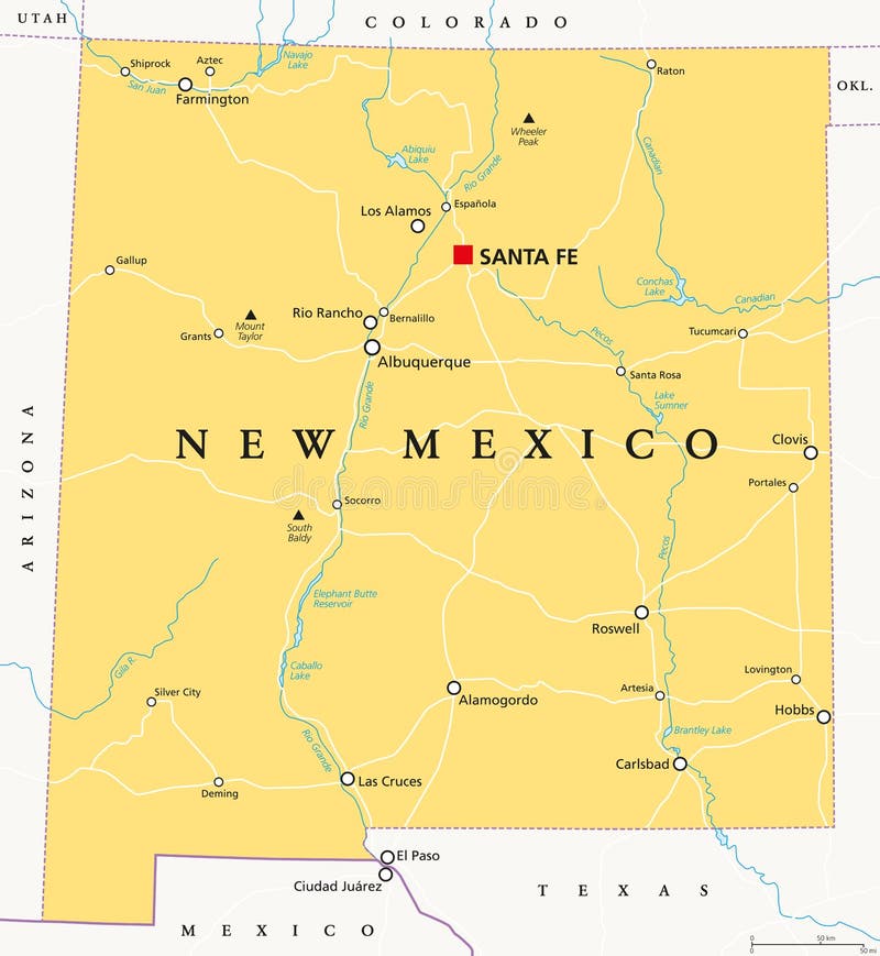
Free with trial New Mexico, political map, with capital Santa Fe, borders, important cities, rivers and lakes. State in the Southwestern region of United States of America. English labeling. Illustration. Vector. Mapping vectors New Mexico, United States, political map. New Mexico, political map, with capital Santa Fe, borders, important cities, rivers and lakes. State in the. New Mexico, political map, with capital Santa Fe, borders, important cities, rivers and lakes. State in the Southwestern region of United States of America. English labeling. Illustration. Vector.
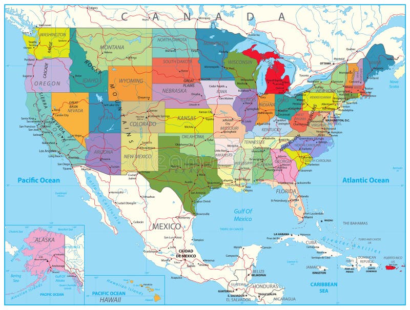
Free with trial USA Political Road Map with roads, water objects and cities. Mapping vectors USA Political Road Map. With roads, water objects and cities
Free with trial A map of the United Kingdom. Size and color can be changed. Mapping vectors A map of the United Kingdom. Size and color can be changed
Free with trial Sphere on arrow vector template with icon. Can use for brochure and business project background. Mapping vectors Sphere on arrow vector template with icon. Can use for brochure and business project background
Free with trial Big Data concept. Abstract vector background. Eps8. RGB Global colors. Mapping vectors Big Data concept. Abstract vector background. Eps8. RGB Global colors
Free with trial Map Sardinia. A stylized map of the italian island Sardinia showing different cities. Vector file also available. Mapping vectors Map Sardinia. A stylized map of the italian island Sardinia showing different cities. Vector file also available
Free with trial Southwest Asia, political map with capitals, borders, rivers and lakes. Also called Western, West or Southwestern Asia. Subregion, overlapping with Middle East. English labeling. Illustration. Vector. Mapping vectors Southwest Asia political map. Southwest Asia, political map with capitals, borders, rivers and lakes. Also called Western, West or Southwestern Asia. Subregion. Southwest Asia, political map with capitals, borders, rivers and lakes. Also called Western, West or Southwestern Asia. Subregion, overlapping with Middle East. English labeling. Illustration. Vector.
Free with trial Polynesia, subregion of Oceania, political map. A region, made up of more than 1000 islands scattered over the central and southern Pacific Ocean. English. Illustration on white background. Vector. Mapping vectors Polynesia, subregion of Oceania, political map. A region, made up of more than 1000 islands scattered over the central and southern Pacific Ocean. English
Free with trial Africa map, isolated and grouped countries of Africa on white. Mapping vectors Africa. Map, isolated and grouped countries of on white
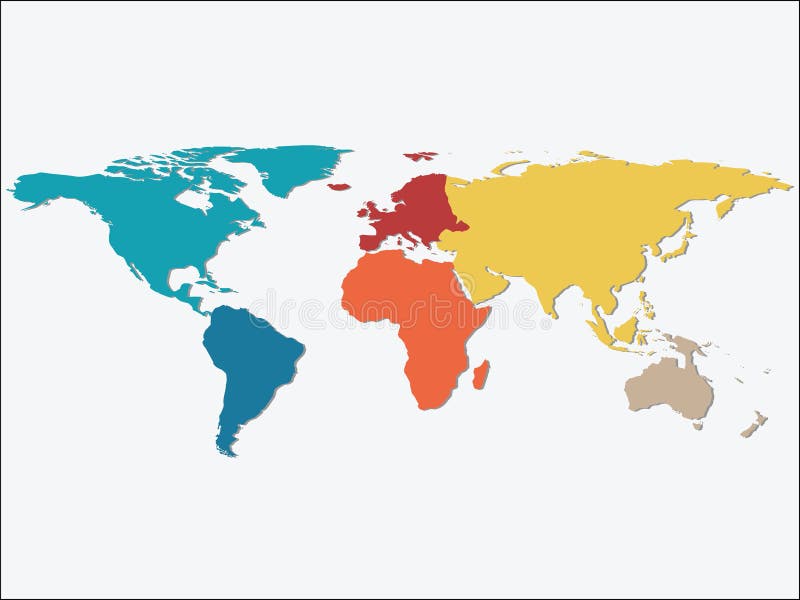
Free with trial Colorful Continents World Map, Credit world map of Nasa. Mapping vectors Colorful Continents World Map. Credit world map of Nasa
Free with trial No found symbol and unsuccessful search. No suitable results, oops page failure concept. Flat outline vector illustration of loupe or magnifier on white background. Flying saucer and cattle. Unknown server error. Mapping vectors No found symbol and unsuccessful search for vecotr. No found symbol and unsuccessful search.No suitable results, oops page failure concept. Flat outline vector. No found symbol and unsuccessful search.No suitable results, oops page failure concept. Flat outline vector illustration of loupe or magnifier on white background.Flying saucer and cattle.Unknown server error
Free with trial Blackboard chalk mind map horizontal seamless. Vector blackboard chalk mind map horizontal seamless pattern background border with hand drawn elements. Mapping vectors Blackboard chalk mind map horizontal seamless. Vector blackboard chalk mind map horizontal seamless pattern background border with hand drawn elements
Free with trial Phone with navigation map. This is file of EPS10 format. Mapping vectors Phone with map. Phone with navigation map. This is file of EPS10 format. Phone with navigation map. This is file of EPS10 format.
Free with trial Pixel world map. Vector illustration of the Pixel world map. Mapping vectors Pixel world map. Vector illustration of the Pixel world map
Free with trial Map pointer. Navigation marker, map pointer, icon. Mapping vectors Map pointer. Navigation marker, map pointer, icon
Free with trial New Hampshire, NH, political map, with capital Concord. State in the New England region of the United States of America. The Granite State. The White Mountain State. Illustration over white. Vector. Mapping vectors New Hampshire, NH, political map, The Granite State. New Hampshire, NH, political map, with capital Concord. State in the New England region of the United States. New Hampshire, NH, political map, with capital Concord. State in the New England region of the United States of America. The Granite State. The White Mountain State. Illustration over white. Vector.
Free with trial Gulf countries new vector map. Oman and Uae, qatar and kuwait, geographic territory graphic. Arabian Peninsula vector illustration. Mapping vectors Gulf countries new vector map. Arabian Peninsula. Gulf countries new vector map. Oman and Uae, qatar and kuwait, geographic territory graphic. Arabian Peninsula. Gulf countries new vector map. Oman and Uae, qatar and kuwait, geographic territory graphic. Arabian Peninsula vector illustration
Free with trial New England region, colored map. A region in the United States of America, consisting of the six states Maine, Vermont, New Hampshire, Massachusetts, Rhode Island and Connecticut. Illustration. Vector. Mapping vectors New England region, colored map, a region in the United States of America. New England region, colored map. A region in the United States of America, consisting. New England region, colored map. A region in the United States of America, consisting of the six states Maine, Vermont, New Hampshire, Massachusetts, Rhode Island and Connecticut. Illustration. Vector
Free with trial City map Rome Italy, travel poster detailed urban street plan, vector illustration. For design. Mapping vectors City map Rome Italy, travel poster detailed urban street plan, vector illustration. For design
Free with trial City Road Maker Construction Kit. City Road construction Kit to Build your own, see my portfolio for other kits. Mapping vectors City Road Maker Construction Kit. City Road construction Kit to Build your own, see my portfolio for other kits
Free with trial Travel poster, urban street plan city map Berlin and Cologne, vector illustration. For design. Mapping vectors Travel poster, urban street plan city map Berlin and Cologne, vector illustration. For design
Free with trial Mobile gps navigation on mobile phone with map and pin vector illustration. Mapping vectors Mobile navigation. Mobile gps navigation on mobile phone with map and pin vector illustration. Mobile gps navigation on mobile phone with map and pin vector illustration.
Free with trial Texas, political map, with capital Austin, borders, important cities, rivers and lakes. State in the South Central region of the United States of America. English labeling. Illustration. Vector. Mapping vectors Texas, United States, political map. Texas, political map, with capital Austin, borders, important cities, rivers and lakes. State in the South Central region of. Texas, political map, with capital Austin, borders, important cities, rivers and lakes. State in the South Central region of the United States of America. English labeling. Illustration. Vector.
Free with trial Halftone world map. World map with circular halftone effect. Mapping vectors Halftone world map. World map with circular halftone effect
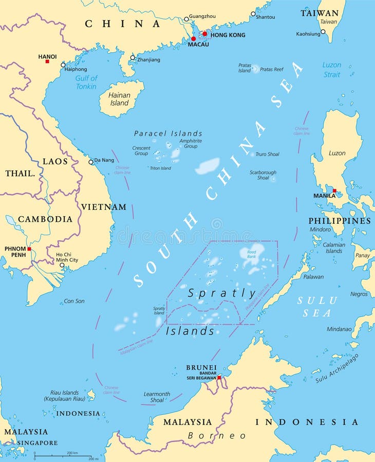
Free with trial South China Sea Islands, political map. Islands, atolls, cays, shoals, reefs and sandbars. Partially claimed by China and other neighboring states. Paracel and Spratly Islands. Illustration. Vector. Mapping vectors South China Sea Islands, political map. Islands, atolls, cays, shoals, reefs and sandbars. Partially claimed by China and other neighboring states. Paracel and
Free with trial European Union countries. Political map with borders. All 28 EU members colored in blue. Political and economic union in Europe. Isolated illustration on white background. Vector. Mapping vectors European Union countries political map. European Union countries. Political map with borders. All 28 EU members colored in blue. Political and economic union in. European Union countries. Political map with borders. All 28 EU members colored in blue. Political and economic union in Europe. Isolated illustration on white background. Vector.
Free with trial City map London England, travel poster detailed urban street plan, vector illustration. For design. Mapping vectors City map London England, travel poster detailed urban street plan, vector illustration. For design
Free with trial California Physical Map - Highly Detailed Relief Map of California State vector illustration - All elements are separated in editable layers clearly labeled. Mapping vectors California Physical Map. Highly Detailed Relief Map of California State vector illustration - All elements are separated in editable layers clearly labeled
Free with trial Vector set face emotion. Vector paper set face emotion. Mapping vectors Vector set face emotion. Vector paper set face emotion
Free with trial Georgia, GA, political map, with capital Atlanta and largest cities. State in the southeastern region of the United States of America. Peach State. Empire State of the South. Illustration. Vector. Mapping vectors Georgia, GA, political map, Peach State, Empire State of the South. Georgia, GA, political map, with capital Atlanta and largest cities. State in the. Georgia, GA, political map, with capital Atlanta and largest cities. State in the southeastern region of the United States of America. Peach State. Empire State of the South. Illustration. Vector.
Free with trial Mind map vector template with hand drawn elements. Mapping vectors Mind map vector template. With hand drawn elements
Free with trial Africa and islands. Editable map of Africa and islands. Mapping vectors Africa and islands. Editable map of Africa and islands
Free with trial Connecting people icons set isolated on white background,Character cartoon, social media conceptual vector illustration. Mapping vectors Connecting people icons set isolated on white background. Connecting people icons set isolated on white background,Character cartoon, social media conceptual. Connecting people icons set isolated on white background,Character cartoon, social media conceptual vector illustration.
Free with trial Delaware, DE, political map. State in the Mid-Atlantic region of the United States of America. Capital Dover. The First State, The Small Wonder, Blue Hen State, The Diamond State. Illustration. Vector. Mapping vectors Delaware, DE, political map, The First State. Delaware, DE, political map. State in the Mid-Atlantic region of the United States of America. Capital Dover. The. Delaware, DE, political map. State in the Mid-Atlantic region of the United States of America. Capital Dover. The First State, The Small Wonder, Blue Hen State, The Diamond State. Illustration. Vector.
Free with trial China Road Map and Map Markers. High detailed China Relief map with labeling. Mapping vectors China Road Map and Map Markers. High detailed China Relief map with labeling
Free with trial Route location icon, two pin sign and dotted line road, start and end journey symbol, black color vector illustration isolated on white background. Mapping vectors Destination route pin icon. Route location icon, two pin sign and dotted line road, start and end journey symbol, black color vector illustration isolated on. Route location icon, two pin sign and dotted line road, start and end journey symbol, black color vector illustration isolated on white background
Free with trial The United States of America, gray political map. Map with the silhouettes of fifty states and postal abbreviations, and with the federal District of Columbia, as it is used for statistics. Vector. Mapping vectors The United States of America, gray political map. Map with the silhouettes of fifty states and postal abbreviations, and with the federal District of Columbia
Free with trial A stylized map of Myanmar showing the different provinces. Mapping vectors Map Myanmar. A stylized map of Myanmar showing the different provinces. A stylized map of Myanmar showing the different provinces.
Free with trial Africa old retro map with separated layers. Mapping vectors Retro vintage map of Africa. Africa old retro map with separated layers. Africa old retro map with separated layers.
Free with trial City map Amsterdam Netherlands, travel poster detailed urban street plan, vector illustration. For design. Mapping vectors City map Amsterdam Netherlands, travel poster detailed urban street plan, vector illustration. For design
Free with trial A stylized map of Colombia showing the different provinces. Mapping vectors Map Colombia. A stylized map of Colombia showing the different provinces. A stylized map of Colombia showing the different provinces.
Free with trial Diagram template for business plan or system. Can use for brochure and business project background. Mapping vectors Diagram template for business plan or system. Can use for brochure and business project background
Free with trial Geography outline concept vector illustration. Atlas earth study and environment research. Topography science and knowledge learning in school or university. Exploration and earth navigation lessons. Mapping vectors Geography outline concept vector illustration. Atlas earth study and environment research. Topography science and knowledge learning in school or university
Free with trial Melanesia, Micronesia and Polynesia, political map. Colored geographic regions of Oceania, southeast of the Asia-Pacific region. English labeling. Illustration on white background. Vector. Mapping vectors Melanesia, Micronesia and Polynesia, political map. Colored geographic regions of Oceania, southeast of the Asia-Pacific region. English labeling. Illustration
Free with trial Vector isometric concept of weather forecast program on tablet P. C. EPS 10 file. Mapping vectors Vector isometric concept of weather forecast program on tablet P. C. EPS 10 file
Free with trial Set of vector social network icons. Mapping vectors Set of vector social network icons. Set of vector social network icons
Free with trial USA Political Road Map and map pointers with roads, water objects and cities. Mapping vectors USA Political Road Map and map pointers. With roads, water objects and cities
Free with trial Travel poster, urban street plan city map Amsterdam and Rotterdam, vector illustration. For design. Mapping vectors Travel poster, urban street plan city map Amsterdam and Rotterdam, vector illustration. For design
Free with trial World map of grey dots background, Dotted World Map - gray world map silhouette on white, vector illustration template concept icon social media wallpaper. Modern Design map world. Business. Mapping vectors World map of grey dots modern design. World map of grey dots background, Dotted World Map - gray world map silhouette on white, vector illustration template. World map of grey dots background, Dotted World Map - gray world map silhouette on white, vector illustration template concept icon social media wallpaper. Modern Design map world. Business
Free with trial Portugal Political Map Vintage Color - Detailed map of Portugal vector illustration - All elements are separated in editable layers clearly labeled. Mapping vectors Portugal Political Map Vintage Color. Detailed map of Portugal vector illustration - All elements are separated in editable layers clearly labeled
Free with trial 3D abstract purple background with paper cut shapes. Design layout for business and elements posters. Colorful carving art. Paper frame backdrop. Vector illustration. Mapping vectors 3D abstract purple background with paper cut shapes. Design layout for business and elements posters. Colorful carving art. Paper frame backdrop. Vector
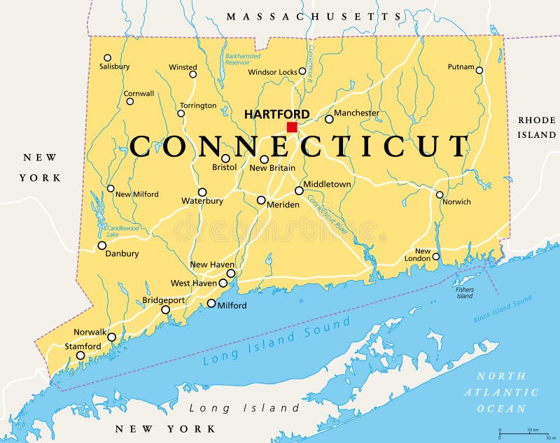
Free with trial Connecticut, political map with capital Hartford. State of Connecticut, CT, the southernmost state in the New England region of the northeastern United States of America. English. Illustration. Vector. Mapping vectors Connecticut, political map, State of Connecticut, CT. Connecticut, political map with capital Hartford. State of Connecticut, CT, the southernmost state in the. Connecticut, political map with capital Hartford. State of Connecticut, CT, the southernmost state in the New England region of the northeastern United States of America. English. Illustration. Vector
Free with trial Route location symbol, map pin sign and road, black icon, vector illustration isolated on white background. Mapping vectors Route location symbol, map pin sign and road, black icon. Vector illustration isolated on white background
Free with trial Vector smart parking concept with parking lot with cars vehicle carpark map. Isolated illustration with city urban landscape, phone navigation application advertising design template. Mapping vectors Vector isometric smart parking concept. Vector smart parking concept with parking lot with cars vehicle carpark map. Isolated illustration with city urban. Vector smart parking concept with parking lot with cars vehicle carpark map. Isolated illustration with city urban landscape, phone navigation application advertising design template
Free with trial Ancestry or Genealogy Icon with Family Tree. Mapping vectors Ancestry or Genealogy Icon with Family Tree. Ancestry / Genealogy Icon w Family Tree
Free with trial Clinical study, healthcare concept banner with keywords and icons and 3D body hologram. Futuristic examination of human health and proper treatment in HUD style. Sci 3D x-ray. Vector medical banner. Mapping vectors Clinical study, healthcare concept banner. With keywords and icons and 3D body hologram. Futuristic examination of human health and proper treatment in HUD. Clinical study, healthcare concept banner with keywords and icons and 3D body hologram. Futuristic examination of human health and proper treatment in HUD style. Sci 3D x-ray. Vector medical banner
Free with trial Detailed borough map of Manhattan New York city, monochrome vector poster or postcard city street plan aerial view. For design. Mapping vectors Detailed borough map of Manhattan New York city, monochrome vector poster or postcard city street plan aerial view. For design
Free with trial Mind map vector seamless pattern background with hand drawn elements. Mapping vectors Mind map vector seamless pattern background. With hand drawn elements
Free with trial Obliqe world map projection. Black and white world map vector illustration. Mapping vectors Obliqe world map projection. Black and white world map vector illustration
Free with trial France, political map. Regions of Metropolitan France. French Republic with capital Paris and 13 administrative regions on the mainland of Europe and their prefectures. English. Illustration. Vector. Mapping vectors France, political map. Regions of Metropolitan France. French Republic with capital Paris and 13 administrative regions on the mainland of Europe and their
Free with trial USA and Canada map with infograpchic elements vector set. Mapping vectors USA and Canada map with infograpchic elements. Vector set
 Sign in