Free with trial Illustrated map of Canada. Tourist and travel landmarks. Vector illustration. Cartography. Maple map vectors Illustrated map of Canada. Tourist and travel landmarks. Vector illustration. Cartography
Free with trial Black flat blank highlighted location map of the YARMOUTH COUNTY inside gray administrative map of counties of Canadian province of Nova Scotia, Canada. Maple map vectors Locator map of the YARMOUTH COUNTY. Black flat blank highlighted location map of the YARMOUTH COUNTY inside gray administrative map of counties of Canadian. Black flat blank highlighted location map of the YARMOUTH COUNTY inside gray administrative map of counties of Canadian province of Nova Scotia, Canada
Free with trial Black flat blank highlighted location map of the RICHMOND COUNTY inside gray administrative map of counties of Canadian province of Nova Scotia, Canada. Maple map vectors Locator map of the RICHMOND COUNTY. Black flat blank highlighted location map of the RICHMOND COUNTY inside gray administrative map of counties of Canadian. Black flat blank highlighted location map of the RICHMOND COUNTY inside gray administrative map of counties of Canadian province of Nova Scotia, Canada
Free with trial Black flat blank highlighted location map of the CARLETON COUNTY inside gray administrative map of counties of Canadian territory of New Brunswick, Canada. Maple map vectors Locator map of the CARLETON COUNTY. Black flat blank highlighted location map of the CARLETON COUNTY inside gray administrative map of counties of Canadian. Black flat blank highlighted location map of the CARLETON COUNTY inside gray administrative map of counties of Canadian territory of New Brunswick, Canada
Free with trial Black flat blank highlighted locator administrative map of the Canadian province of SASKATCHEWAN inside gray flat map of CANADA. Maple map vectors Locator map of SASKATCHEWAN, CANADA. Black flat blank highlighted locator administrative map of the Canadian province of SASKATCHEWAN inside gray flat map of. Black flat blank highlighted locator administrative map of the Canadian province of SASKATCHEWAN inside gray flat map of CANADA
Free with trial Black flat blank highlighted location map of the KENORA DISTRICT inside gray administrative map of the Canadian province of Ontario, Canada. Maple map vectors Locator map of the KENORA DISTRICT. Black flat blank highlighted location map of the KENORA DISTRICT inside gray administrative map of the Canadian province of. Black flat blank highlighted location map of the KENORA DISTRICT inside gray administrative map of the Canadian province of Ontario, Canada
Free with trial Black flat blank highlighted location map of the MAURICIE Region inside gray administrative map of the Canadian province of Quebec, Canada. Maple map vectors Locator map of the MAURICIE Region. Black flat blank highlighted location map of the MAURICIE Region inside gray administrative map of the Canadian province of. Black flat blank highlighted location map of the MAURICIE Region inside gray administrative map of the Canadian province of Quebec, Canada
Free with trial Black flat blank highlighted location map of the ALGOMA DISTRICT inside gray administrative map of the Canadian province of Ontario, Canada. Maple map vectors Locator map of the ALGOMA DISTRICT. Black flat blank highlighted location map of the ALGOMA DISTRICT inside gray administrative map of the Canadian province of. Black flat blank highlighted location map of the ALGOMA DISTRICT inside gray administrative map of the Canadian province of Ontario, Canada
Free with trial Black flat blank highlighted location map of the MONTREAL Region inside gray administrative map of the Canadian province of Quebec, Canada. Maple map vectors Locator map of the MONTREAL Region. Black flat blank highlighted location map of the MONTREAL Region inside gray administrative map of the Canadian province of. Black flat blank highlighted location map of the MONTREAL Region inside gray administrative map of the Canadian province of Quebec, Canada
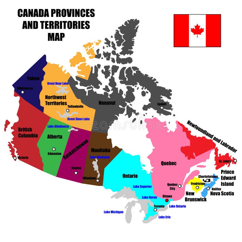
Free with trial Full Canada Vector Map of Provinces, Territories and Capitals in bright colors. Maple map vectors Full Canada Vector Map of Provinces, Territories and Capitals in bright colors. Full Canada Vector Map of Provinces, Territories and Capitals in bright colors
Free with trial Black flat blank highlighted location map of the HASTINGS COUNTY inside gray administrative map of the Canadian province of Ontario, Canada. Maple map vectors Locator map of the HASTINGS COUNTY. Black flat blank highlighted location map of the HASTINGS COUNTY inside gray administrative map of the Canadian province of. Black flat blank highlighted location map of the HASTINGS COUNTY inside gray administrative map of the Canadian province of Ontario, Canada
Free with trial Black flat blank highlighted location map of the DUFFERIN COUNTY inside gray administrative map of the Canadian province of Ontario, Canada. Maple map vectors Locator map of the DUFFERIN COUNTY. Black flat blank highlighted location map of the DUFFERIN COUNTY inside gray administrative map of the Canadian province of. Black flat blank highlighted location map of the DUFFERIN COUNTY inside gray administrative map of the Canadian province of Ontario, Canada
Free with trial Quebec Map on Canadian Flag. QC, CA Province Map on Canada Flag. EPS Vector Graphic Clipart Icon. Maple map vectors Quebec Map on Canadian Flag. QC, CA Province Map on Canada Flag. EPS Vector Graphic Clipart Icon.
Free with trial Yukon Map on Canadian Flag. YT, CA Territory Map on Canada Flag. EPS Vector Graphic Clipart Icon. Maple map vectors Yukon Map on Canadian Flag. YT, CA Territory Map on Canada Flag. EPS Vector Graphic Clipart Icon.
Free with trial Black flat blank highlighted location map of the LUNENBURG COUNTY inside gray administrative map of counties of Canadian province of Nova Scotia, Canada. Maple map vectors Locator map of the LUNENBURG COUNTY. Black flat blank highlighted location map of the LUNENBURG COUNTY inside gray administrative map of counties of Canadian. Black flat blank highlighted location map of the LUNENBURG COUNTY inside gray administrative map of counties of Canadian province of Nova Scotia, Canada
Free with trial Black flat blank highlighted location map of the ANNAPOLIS COUNTY inside gray administrative map of counties of Canadian province of Nova Scotia, Canada. Maple map vectors Locator map of the ANNAPOLIS COUNTY. Black flat blank highlighted location map of the ANNAPOLIS COUNTY inside gray administrative map of counties of Canadian. Black flat blank highlighted location map of the ANNAPOLIS COUNTY inside gray administrative map of counties of Canadian province of Nova Scotia, Canada
Free with trial Black flat blank highlighted location map of the INVERNESS COUNTY inside gray administrative map of counties of Canadian province of Nova Scotia, Canada. Maple map vectors Locator map of the INVERNESS COUNTY. Black flat blank highlighted location map of the INVERNESS COUNTY inside gray administrative map of counties of Canadian. Black flat blank highlighted location map of the INVERNESS COUNTY inside gray administrative map of counties of Canadian province of Nova Scotia, Canada
Free with trial Black flat blank highlighted location map of the SHELBURNE COUNTY inside gray administrative map of counties of Canadian province of Nova Scotia, Canada. Maple map vectors Locator map of the SHELBURNE COUNTY. Black flat blank highlighted location map of the SHELBURNE COUNTY inside gray administrative map of counties of Canadian. Black flat blank highlighted location map of the SHELBURNE COUNTY inside gray administrative map of counties of Canadian province of Nova Scotia, Canada
Free with trial Black flat blank highlighted location map of the CHARLOTTE COUNTY inside gray administrative map of counties of Canadian territory of New Brunswick, Canada. Maple map vectors Locator map of the CHARLOTTE COUNTY. Black flat blank highlighted location map of the CHARLOTTE COUNTY inside gray administrative map of counties of Canadian. Black flat blank highlighted location map of the CHARLOTTE COUNTY inside gray administrative map of counties of Canadian territory of New Brunswick, Canada
Free with trial Black flat blank highlighted location map of the MADAWASKA COUNTY inside gray administrative map of counties of Canadian territory of New Brunswick, Canada. Maple map vectors Locator map of the MADAWASKA COUNTY. Black flat blank highlighted location map of the MADAWASKA COUNTY inside gray administrative map of counties of Canadian. Black flat blank highlighted location map of the MADAWASKA COUNTY inside gray administrative map of counties of Canadian territory of New Brunswick, Canada
Free with trial Black flat blank highlighted location map of the COTE-NORD Region inside gray administrative map of the Canadian province of Quebec, Canada. Maple map vectors Locator map of the COTE-NORD Region. Black flat blank highlighted location map of the COTE-NORD Region inside gray administrative map of the Canadian province of. Black flat blank highlighted location map of the COTE-NORD Region inside gray administrative map of the Canadian province of Quebec, Canada
Free with trial Black flat blank highlighted location map of the SUDBURY DISTRICT inside gray administrative map of the Canadian province of Ontario, Canada. Maple map vectors Locator map of the SUDBURY DISTRICT. Black flat blank highlighted location map of the SUDBURY DISTRICT inside gray administrative map of the Canadian province of. Black flat blank highlighted location map of the SUDBURY DISTRICT inside gray administrative map of the Canadian province of Ontario, Canada
Free with trial Black flat blank highlighted location map of the OUTAOUAIS Region inside gray administrative map of the Canadian province of Quebec, Canada. Maple map vectors Locator map of the OUTAOUAIS Region. Black flat blank highlighted location map of the OUTAOUAIS Region inside gray administrative map of the Canadian province of. Black flat blank highlighted location map of the OUTAOUAIS Region inside gray administrative map of the Canadian province of Quebec, Canada
Free with trial Map of new brunswick, canada. Vector illustration decorative background design. Conceptual vector. Maple map vectors Map of new brunswick, canada. Vector illustration decorative background design. Conceptual vector
Free with trial Black flat blank highlighted location map of the FRONTENAC COUNTY inside gray administrative map of the Canadian province of Ontario, Canada. Maple map vectors Locator map of the FRONTENAC COUNTY. Black flat blank highlighted location map of the FRONTENAC COUNTY inside gray administrative map of the Canadian province of. Black flat blank highlighted location map of the FRONTENAC COUNTY inside gray administrative map of the Canadian province of Ontario, Canada
Free with trial Alberta Map on Canadian Flag. AB, CA Province Map on Canada Flag. EPS Vector Graphic Clipart Icon. Maple map vectors Alberta Map on Canadian Flag. AB, CA Province Map on Canada Flag. EPS Vector Graphic Clipart Icon.
Free with trial Black flat blank highlighted location map of the CUMBERLAND COUNTY inside gray administrative map of counties of Canadian province of Nova Scotia, Canada. Maple map vectors Locator map of the CUMBERLAND COUNTY. Black flat blank highlighted location map of the CUMBERLAND COUNTY inside gray administrative map of counties of Canadian. Black flat blank highlighted location map of the CUMBERLAND COUNTY inside gray administrative map of counties of Canadian province of Nova Scotia, Canada
Free with trial Black flat blank highlighted location map of the ANTIGONISH COUNTY inside gray administrative map of counties of Canadian province of Nova Scotia, Canada. Maple map vectors Locator map of the ANTIGONISH COUNTY. Black flat blank highlighted location map of the ANTIGONISH COUNTY inside gray administrative map of counties of Canadian. Black flat blank highlighted location map of the ANTIGONISH COUNTY inside gray administrative map of counties of Canadian province of Nova Scotia, Canada
Free with trial Black flat blank highlighted location map of the COLCHESTER COUNTY inside gray administrative map of counties of Canadian province of Nova Scotia, Canada. Maple map vectors Locator map of the COLCHESTER COUNTY. Black flat blank highlighted location map of the COLCHESTER COUNTY inside gray administrative map of counties of Canadian. Black flat blank highlighted location map of the COLCHESTER COUNTY inside gray administrative map of counties of Canadian province of Nova Scotia, Canada
Free with trial Black flat blank highlighted location map of the GLOUCESTER COUNTY inside gray administrative map of counties of Canadian territory of New Brunswick, Canada. Maple map vectors Locator map of the GLOUCESTER COUNTY. Black flat blank highlighted location map of the GLOUCESTER COUNTY inside gray administrative map of counties of Canadian. Black flat blank highlighted location map of the GLOUCESTER COUNTY inside gray administrative map of counties of Canadian territory of New Brunswick, Canada
Free with trial Black flat blank highlighted location map of the SAINT JOHN COUNTY inside gray administrative map of counties of Canadian territory of New Brunswick, Canada. Maple map vectors Locator map of the SAINT JOHN COUNTY. Black flat blank highlighted location map of the SAINT JOHN COUNTY inside gray administrative map of counties of Canadian. Black flat blank highlighted location map of the SAINT JOHN COUNTY inside gray administrative map of counties of Canadian territory of New Brunswick, Canada
Free with trial Black flat blank highlighted location map of the SPECIAL AREA NO. 4 inside gray administrative map of the Canadian province of Alberta, Canada. Maple map vectors Locator map of the SPECIAL AREA NO. 4. Black flat blank highlighted location map of the SPECIAL AREA NO. 4 inside gray administrative map of the Canadian. Black flat blank highlighted location map of the SPECIAL AREA NO. 4 inside gray administrative map of the Canadian province of Alberta, Canada
Free with trial Black flat blank highlighted location map of the SPECIAL AREA NO. 2 inside gray administrative map of the Canadian province of Alberta, Canada. Maple map vectors Locator map of the SPECIAL AREA NO. 2. Black flat blank highlighted location map of the SPECIAL AREA NO. 2 inside gray administrative map of the Canadian. Black flat blank highlighted location map of the SPECIAL AREA NO. 2 inside gray administrative map of the Canadian province of Alberta, Canada
Free with trial Black flat blank highlighted location map of the SPECIAL AREA NO. 3 inside gray administrative map of the Canadian province of Alberta, Canada. Maple map vectors Locator map of the SPECIAL AREA NO. 3. Black flat blank highlighted location map of the SPECIAL AREA NO. 3 inside gray administrative map of the Canadian. Black flat blank highlighted location map of the SPECIAL AREA NO. 3 inside gray administrative map of the Canadian province of Alberta, Canada
Free with trial Black flat blank highlighted location map of the MONTEREGIE Region inside gray administrative map of the Canadian province of Quebec, Canada. Maple map vectors Locator map of the MONTEREGIE Region. Black flat blank highlighted location map of the MONTEREGIE Region inside gray administrative map of the Canadian province. Black flat blank highlighted location map of the MONTEREGIE Region inside gray administrative map of the Canadian province of Quebec, Canada
Free with trial Black flat blank highlighted location map of the LANAUDIERE Region inside gray administrative map of the Canadian province of Quebec, Canada. Maple map vectors Locator map of the LANAUDIERE Region. Black flat blank highlighted location map of the LANAUDIERE Region inside gray administrative map of the Canadian province. Black flat blank highlighted location map of the LANAUDIERE Region inside gray administrative map of the Canadian province of Quebec, Canada
Free with trial Black flat blank highlighted location map of the WELLINGTON COUNTY inside gray administrative map of the Canadian province of Ontario, Canada. Maple map vectors Locator map of the WELLINGTON COUNTY. Black flat blank highlighted location map of the WELLINGTON COUNTY inside gray administrative map of the Canadian province. Black flat blank highlighted location map of the WELLINGTON COUNTY inside gray administrative map of the Canadian province of Ontario, Canada
Free with trial Black flat blank highlighted location map of the COCHRANE DISTRICT inside gray administrative map of the Canadian province of Ontario, Canada. Maple map vectors Locator map of the COCHRANE DISTRICT. Black flat blank highlighted location map of the COCHRANE DISTRICT inside gray administrative map of the Canadian province. Black flat blank highlighted location map of the COCHRANE DISTRICT inside gray administrative map of the Canadian province of Ontario, Canada
Free with trial Locator map of the KING MUNICIPALITY. Black flat blank highlighted location map of the KING MUNICIPALITY inside gray administrative map of Greater Toronto Area. Maple map vectors Locator map of the KING MUNICIPALITY. Black flat blank highlighted location map of the KING MUNICIPALITY inside gray administrative map of Greater Toronto Area
Free with trial Canada Travel Guide Flat Map Poster. Canada travel guide for tourists flat infographic poster with country map landmarks and cultural symbols vector illustration. Maple map vectors Canada Travel Guide Flat Map Poster. Canada travel guide for tourists flat infographic poster with country map landmarks and cultural symbols vector illustration
Free with trial Black flat blank highlighted location map of the KITIKMEOT-KITIKMEOT Region inside gray administrative map of the Canadian territory of Nunavut, Canada. Maple map vectors Location map of the KITIKMEOT-KITIKMEOT Region. Black flat blank highlighted location map of the KITIKMEOT-KITIKMEOT Region inside gray administrative map of the. Black flat blank highlighted location map of the KITIKMEOT-KITIKMEOT Region inside gray administrative map of the Canadian territory of Nunavut, Canada
Free with trial Black flat blank highlighted location map of the AIVILIK District inside gray administrative map of the territorial electoral districts of Canadian territory of Nunavut, Canada. Maple map vectors Location map of the AIVILIK District. Black flat blank highlighted location map of the AIVILIK District inside gray administrative map of the territorial. Black flat blank highlighted location map of the AIVILIK District inside gray administrative map of the territorial electoral districts of Canadian territory of Nunavut, Canada
Free with trial Black flat blank highlighted location map of the AMITTUQ District inside gray administrative map of the territorial electoral districts of Canadian territory of Nunavut, Canada. Maple map vectors Location map of the AMITTUQ District. Black flat blank highlighted location map of the AMITTUQ District inside gray administrative map of the territorial. Black flat blank highlighted location map of the AMITTUQ District inside gray administrative map of the territorial electoral districts of Canadian territory of Nunavut, Canada
Free with trial Canada Maple Leaf Red and White Flag in wide circle. Maple map vectors Canada Maple Leaf Red and White Flag in wide circle. Canada Maple Leaf Red and White Flag in wide circle
Free with trial Black flat blank highlighted location map of the AJAX MUNICIPALITY inside gray administrative map of Greater Toronto Area. Maple map vectors Locator map of the AJAX MUNICIPALITY. Black flat blank highlighted location map of the AJAX. Black flat blank highlighted location map of the AJAX MUNICIPALITY inside gray administrative map of Greater Toronto Area
Free with trial Black map of BRITISH COLUMBIA, CANADA. Black flat blank vector administrative map of the Canadian province of BRITISH COLUMBIA, CANADA. Maple map vectors Black map of BRITISH COLUMBIA, CANADA. Black flat blank vector administrative map of the Canadian province of BRITISH COLUMBIA, CANADA
Free with trial Black flat blank highlighted location map of the HALIBURTON COUNTY inside gray administrative map of the Canadian province of Ontario, Canada. Maple map vectors Locator map of the HALIBURTON COUNTY. Black flat blank highlighted location map of the HALIBURTON COUNTY inside gray administrative map of the Canadian province. Black flat blank highlighted location map of the HALIBURTON COUNTY inside gray administrative map of the Canadian province of Ontario, Canada
Free with trial Black flat blank highlighted location map of the TUNUNIQ District inside gray administrative map of the territorial electoral districts of Canadian territory of Nunavut, Canada. Maple map vectors Location map of the TUNUNIQ District. Black flat blank highlighted location map of the TUNUNIQ District inside gray administrative map of the territorial. Black flat blank highlighted location map of the TUNUNIQ District inside gray administrative map of the territorial electoral districts of Canadian territory of Nunavut, Canada
Free with trial Nunavut Map on Canadian Flag. NU, CA Territory Map on Canada Flag. EPS Vector Graphic Clipart Icon. Maple map vectors Nunavut Map on Canadian Flag. NU, CA Territory Map on Canada Flag. EPS Vector Graphic Clipart Icon.
Free with trial Black flat blank highlighted location map of the GUYSBOROUGH COUNTY inside gray administrative map of counties of Canadian province of Nova Scotia, Canada. Maple map vectors Locator map of the GUYSBOROUGH COUNTY. Black flat blank highlighted location map of the GUYSBOROUGH COUNTY inside gray administrative map of counties of Canadian. Black flat blank highlighted location map of the GUYSBOROUGH COUNTY inside gray administrative map of counties of Canadian province of Nova Scotia, Canada
Free with trial Black flat blank highlighted location map of the CAPE BRETON COUNTY inside gray administrative map of counties of Canadian province of Nova Scotia, Canada. Maple map vectors Locator map of the CAPE BRETON COUNTY. Black flat blank highlighted location map of the CAPE BRETON COUNTY inside gray administrative map of counties of Canadian. Black flat blank highlighted location map of the CAPE BRETON COUNTY inside gray administrative map of counties of Canadian province of Nova Scotia, Canada
Free with trial Black flat blank highlighted location map of the WESTMORLAND COUNTY inside gray administrative map of counties of Canadian territory of New Brunswick, Canada. Maple map vectors Locator map of the WESTMORLAND COUNTY. Black flat blank highlighted location map of the WESTMORLAND COUNTY inside gray administrative map of counties of Canadian. Black flat blank highlighted location map of the WESTMORLAND COUNTY inside gray administrative map of counties of Canadian territory of New Brunswick, Canada
Free with trial Black flat blank highlighted location map of the RESTIGOUCHE COUNTY inside gray administrative map of counties of Canadian territory of New Brunswick, Canada. Maple map vectors Locator map of the RESTIGOUCHE COUNTY. Black flat blank highlighted location map of the RESTIGOUCHE COUNTY inside gray administrative map of counties of Canadian. Black flat blank highlighted location map of the RESTIGOUCHE COUNTY inside gray administrative map of counties of Canadian territory of New Brunswick, Canada
Free with trial Flag map of YUKON, CANADA. Flat vector administrative flag map of the Canadian territory of YUKON combined with official flag of CANADA. Maple map vectors Flag map of YUKON, CANADA. Flat vector administrative flag map of the Canadian territory of YUKON combined with official flag of CANADA
Free with trial Flag map of YUKON, CANADA. Flat vector administrative flag map of the Canadian territory of YUKON, CANADA. Maple map vectors Flag map of YUKON, CANADA. Flat vector administrative flag map of the Canadian territory of YUKON, CANADA
Free with trial Black flat blank highlighted location map of the LAURENTIDES Region inside gray administrative map of the Canadian province of Quebec, Canada. Maple map vectors Locator map of the LAURENTIDES Region. Black flat blank highlighted location map of the LAURENTIDES Region inside gray administrative map of the Canadian. Black flat blank highlighted location map of the LAURENTIDES Region inside gray administrative map of the Canadian province of Quebec, Canada
Free with trial Black flat blank highlighted location map of the ActonnRegional County Municipality inside gray administrative map of Montérégie, Quebec, Canada. Maple map vectors Locator map of the Acton Municipality. Black flat blank highlighted location map of the ActonnRegional County Municipality inside gray administrative map of Mont. Black flat blank highlighted location map of the ActonnRegional County Municipality inside gray administrative map of Montérégie, Quebec, Canada
Free with trial Black flat blank highlighted location map of the NIPISSING DISTRICT inside gray administrative map of the Canadian province of Ontario, Canada. Maple map vectors Locator map of the NIPISSING DISTRICT. Black flat blank highlighted location map of the NIPISSING DISTRICT inside gray administrative map of the Canadian. Black flat blank highlighted location map of the NIPISSING DISTRICT inside gray administrative map of the Canadian province of Ontario, Canada
Free with trial Greater Toronto map. Isolated on gray background. Maple map vectors Greater Toronto map. Isolated on gray background
Free with trial Locator map of the BROCK MUNICIPALITY. Black flat blank highlighted location map of the BROCK MUNICIPALITY inside gray administrative map of Greater Toronto Area. Maple map vectors Locator map of the BROCK MUNICIPALITY. Black flat blank highlighted location map of the BROCK MUNICIPALITY inside gray administrative map of Greater Toronto Area
Free with trial Black flat blank highlighted location map of the NETSILIK District inside gray administrative map of the territorial electoral districts of Canadian territory of Nunavut, Canada. Maple map vectors Location map of the NETSILIK District. Black flat blank highlighted location map of the NETSILIK District inside gray administrative map of the territorial. Black flat blank highlighted location map of the NETSILIK District inside gray administrative map of the territorial electoral districts of Canadian territory of Nunavut, Canada
Free with trial Simple gray vector flag map of CANADA. Simple vector administrative flag map of CANADA. Maple map vectors Simple gray vector flag map of CANADA. Simple vector administrative flag map of CANADA
Free with trial Flag of Canada. Sketch. Vector illustration. Coloring book for children. The fabric is decorated with a maple leaf. The national symbol of the state develops in the wind. Outline on isolated background. Political themes. Doodle style. Idea for educational literature, web design. Maple map vectors Flag of Canada. Sketch. Vector illustration. Coloring book for children. The fabric is decorated with a maple leaf. The national symbol of the state develops
Free with trial Black flat blank highlighted location map of the SAGUENAY–LAC-SAINT-JEAN Region inside gray administrative map of the Canadian province of Quebec, Canada. Maple map vectors Locator map of the SAGUENAY–LAC-SAINT-JEAN Region. Black flat blank highlighted location map of the SAGUENAY–LAC-SAINT-JEAN Region inside gray administrative. Black flat blank highlighted location map of the SAGUENAY–LAC-SAINT-JEAN Region inside gray administrative map of the Canadian province of Quebec, Canada
Free with trial Flag map of QUEBEC, CANADA. Flat vector administrative flag map of the Canadian province of QUEBEC, CANADA. Maple map vectors Flag map of QUEBEC, CANADA. Flat vector administrative flag map of the Canadian province of QUEBEC, CANADA
Free with trial Black flat blank highlighted location map of the MANITOULIN DISTRICT inside gray administrative map of the Canadian province of Ontario, Canada. Maple map vectors Locator map of the MANITOULIN DISTRICT. Black flat blank highlighted location map of the MANITOULIN DISTRICT inside gray administrative map of the Canadian. Black flat blank highlighted location map of the MANITOULIN DISTRICT inside gray administrative map of the Canadian province of Ontario, Canada
Free with trial Black flat blank highlighted location map of the AURORA MUNICIPALITY inside gray administrative map of Greater Toronto Area. Maple map vectors Locator map of the AURORA MUNICIPALITY. Black flat blank highlighted location map of the AURORA MUNICIPALITY inside gray administrative map of Greater Toronto. Black flat blank highlighted location map of the AURORA MUNICIPALITY inside gray administrative map of Greater Toronto Area
Free with trial Black flat blank highlighted location map of the WHITBY MUNICIPALITY inside gray administrative map of Greater Toronto Area. Maple map vectors Locator map of the WHITBY MUNICIPALITY. Black flat blank highlighted location map of the WHITBY MUNICIPALITY inside gray administrative map of Greater Toronto. Black flat blank highlighted location map of the WHITBY MUNICIPALITY inside gray administrative map of Greater Toronto Area
Free with trial Black flat blank highlighted location map of the OSHAWA MUNICIPALITY inside gray administrative map of Greater Toronto Area. Maple map vectors Locator map of the OSHAWA MUNICIPALITY. Black flat blank highlighted location map of the OSHAWA MUNICIPALITY inside gray administrative map of Greater Toronto. Black flat blank highlighted location map of the OSHAWA MUNICIPALITY inside gray administrative map of Greater Toronto Area
Free with trial Black flat blank highlighted location map of the MILTON MUNICIPALITY inside gray administrative map of Greater Toronto Area. Maple map vectors Locator map of the MILTON MUNICIPALITY. Black flat blank highlighted location map of the MILTON MUNICIPALITY inside gray administrative map of Greater Toronto. Black flat blank highlighted location map of the MILTON MUNICIPALITY inside gray administrative map of Greater Toronto Area
Free with trial Black flat blank highlighted locator administrative map of the Canadian province of BRITISH COLUMBIA inside gray flat map of CANADA. Maple map vectors Locator map of BRITISH COLUMBIA, CANADA. Black flat blank highlighted locator administrative map of the Canadian province of BRITISH COLUMBIA inside gray flat. Black flat blank highlighted locator administrative map of the Canadian province of BRITISH COLUMBIA inside gray flat map of CANADA
Free with trial Black flat blank highlighted location map of the SCUGOG MUNICIPALITY inside gray administrative map of Greater Toronto Area. Maple map vectors Locator map of the SCUGOG MUNICIPALITY. Black flat blank highlighted location map of the SCUGOG MUNICIPALITY inside gray administrative map of Greater Toronto. Black flat blank highlighted location map of the SCUGOG MUNICIPALITY inside gray administrative map of Greater Toronto Area
Free with trial Black flat blank highlighted location map of the PETERBOROUGH COUNTY inside gray administrative map of the Canadian province of Ontario, Canada. Maple map vectors Locator map of the PETERBOROUGH COUNTY. Black flat blank highlighted location map of the PETERBOROUGH COUNTY inside gray administrative map of the Canadian. Black flat blank highlighted location map of the PETERBOROUGH COUNTY inside gray administrative map of the Canadian province of Ontario, Canada
Free with trial Black flat blank highlighted location map of the KUGLUKTUK District inside gray administrative map of the territorial electoral districts of Canadian territory of Nunavut, Canada. Maple map vectors Location map of the KUGLUKTUK District. Black flat blank highlighted location map of the KUGLUKTUK District inside gray administrative map of the territorial. Black flat blank highlighted location map of the KUGLUKTUK District inside gray administrative map of the territorial electoral districts of Canadian territory of Nunavut, Canada
Free with trial Black flat blank highlighted location map of the QUTTIKTUQ District inside gray administrative map of the territorial electoral districts of Canadian territory of Nunavut, Canada. Maple map vectors Location map of the QUTTIKTUQ District. Black flat blank highlighted location map of the QUTTIKTUQ District inside gray administrative map of the territorial. Black flat blank highlighted location map of the QUTTIKTUQ District inside gray administrative map of the territorial electoral districts of Canadian territory of Nunavut, Canada
Free with trial Black flat blank highlighted location map of the UQQUMMIUT District inside gray administrative map of the territorial electoral districts of Canadian territory of Nunavut, Canada. Maple map vectors Location map of the UQQUMMIUT District. Black flat blank highlighted location map of the UQQUMMIUT District inside gray administrative map of the territorial. Black flat blank highlighted location map of the UQQUMMIUT District inside gray administrative map of the territorial electoral districts of Canadian territory of Nunavut, Canada
Free with trial Gray flat blank vector administrative map of counties of Canadian province of NOVA SCOTIA, CANADA with white border lines of its counties. Maple map vectors Gray map of counties of NOVA SCOTIA, CANADA. Gray flat blank vector administrative map of counties of Canadian province of NOVA SCOTIA, CANADA with white border. Gray flat blank vector administrative map of counties of Canadian province of NOVA SCOTIA, CANADA with white border lines of its counties
Free with trial Flag map of ALBERTA, CANADA. Flat vector administrative flag map of the Canadian province of ALBERTA combined with official flag of CANADA. Maple map vectors Flag map of ALBERTA, CANADA. Flat vector administrative flag map of the Canadian province of ALBERTA combined with official flag of CANADA
Free with trial Black flat blank highlighted location map of the TIMISKAMING DISTRICT inside gray administrative map of the Canadian province of Ontario, Canada. Maple map vectors Locator map of the TIMISKAMING DISTRICT. Black flat blank highlighted location map of the TIMISKAMING DISTRICT inside gray administrative map of the Canadian. Black flat blank highlighted location map of the TIMISKAMING DISTRICT inside gray administrative map of the Canadian province of Ontario, Canada
Free with trial Black flat blank highlighted location map of the THUNDER BAY DISTRICT inside gray administrative map of the Canadian province of Ontario, Canada. Maple map vectors Locator map of the THUNDER BAY DISTRICT. Black flat blank highlighted location map of the THUNDER BAY DISTRICT inside gray administrative map of the Canadian. Black flat blank highlighted location map of the THUNDER BAY DISTRICT inside gray administrative map of the Canadian province of Ontario, Canada
 Sign in