Free with trial Black flat blank highlighted location map of the SMOKY RIVER NO. 130 municipal district inside gray administrative map of the Canadian province of Alberta, Canada. Maple map vectors Locator map of the SMOKY RIVER NO. 130 municipal district. Black flat blank highlighted location map of the SMOKY RIVER NO. 130 municipal district inside gray. Black flat blank highlighted location map of the SMOKY RIVER NO. 130 municipal district inside gray administrative map of the Canadian province of Alberta, Canada
Free with trial Black flat blank highlighted location map of the PINCHER CREEK NO. 9 municipal district inside gray administrative map of the Canadian province of Alberta, Canada. Maple map vectors Locator map of the PINCHER CREEK NO. 9 municipal district. Black flat blank highlighted location map of the PINCHER CREEK NO. 9 municipal district inside gray. Black flat blank highlighted location map of the PINCHER CREEK NO. 9 municipal district inside gray administrative map of the Canadian province of Alberta, Canada
Free with trial Black flat blank highlighted location map of the CLEAR HILLS COUNTY municipal district inside gray administrative map of the Canadian province of Alberta, Canada. Maple map vectors Locator map of the CLEAR HILLS COUNTY municipal district. Black flat blank highlighted location map of the CLEAR HILLS COUNTY municipal district inside gray. Black flat blank highlighted location map of the CLEAR HILLS COUNTY municipal district inside gray administrative map of the Canadian province of Alberta, Canada
Free with trial White flat vector administrative map of the regions of Canadian territory of NORTHWEST TERRITORIES, CANADA with black border lines and name tags of its regions. Maple map vectors White tagged map of regions of NORTHWEST TERRITORIES, CANADA. White flat vector administrative map of the regions of Canadian territory of NORTHWEST TERRITORIES. White flat vector administrative map of the regions of Canadian territory of NORTHWEST TERRITORIES, CANADA with black border lines and name tags of its regions
Free with trial Black flat blank highlighted location map of the COUNTY OF BRANT single-tier municipality inside gray administrative map of the Canadian province of Ontario, Canada. Maple map vectors Locator map of the COUNTY OF BRANT single-tier municipality. Black flat blank highlighted location map of the COUNTY OF BRANT single-tier municipality inside. Black flat blank highlighted location map of the COUNTY OF BRANT single-tier municipality inside gray administrative map of the Canadian province of Ontario, Canada
Free with trial Black flat blank highlighted location map of the CHATHAM-KENT single-tier municipality inside gray administrative map of the Canadian province of Ontario, Canada. Maple map vectors Locator map of the CHATHAM-KENT single-tier municipality. Black flat blank highlighted location map of the CHATHAM-KENT single-tier municipality inside gray. Black flat blank highlighted location map of the CHATHAM-KENT single-tier municipality inside gray administrative map of the Canadian province of Ontario, Canada
Free with trial Black flat blank highlighted location map of the COUNTY OF WARNER NO. 5 municipal district inside gray administrative map of the Canadian province of Alberta, Canada. Maple map vectors Locator map of the COUNTY OF WARNER NO. 5 municipal district. Black flat blank highlighted location map of the COUNTY OF WARNER NO. 5 municipal district inside. Black flat blank highlighted location map of the COUNTY OF WARNER NO. 5 municipal district inside gray administrative map of the Canadian province of Alberta, Canada
Free with trial Black flat blank highlighted location map of the BIRCH HILLS COUNTY municipal district inside gray administrative map of the Canadian province of Alberta, Canada. Maple map vectors Locator map of the BIRCH HILLS COUNTY municipal district. Black flat blank highlighted location map of the BIRCH HILLS COUNTY municipal district inside gray. Black flat blank highlighted location map of the BIRCH HILLS COUNTY municipal district inside gray administrative map of the Canadian province of Alberta, Canada
Free with trial White flat vector administrative map of counties of Canadian province of PRINCE EDWARD ISLAND, CANADA with black border lines and name tags of its counties. Maple map vectors White tagged map of counties of PRINCE EDWARD ISLAND, CANADA. White flat vector administrative map of counties of Canadian province of PRINCE EDWARD ISLAND. White flat vector administrative map of counties of Canadian province of PRINCE EDWARD ISLAND, CANADA with black border lines and name tags of its counties
Free with trial Black flat blank highlighted location map of the IMPROVEMENT DISTRICT NO. 13 ELK ISLAND inside gray administrative map of the Canadian province of Alberta, Canada. Maple map vectors Locator map of the IMPROVEMENT DISTRICT NO. 13 ELK ISLAND. Black flat blank highlighted location map of the IMPROVEMENT DISTRICT NO. 13 ELK ISLAND inside gray. Black flat blank highlighted location map of the IMPROVEMENT DISTRICT NO. 13 ELK ISLAND inside gray administrative map of the Canadian province of Alberta, Canada
Free with trial Black flat blank highlighted location map of the WILLOW CREEK NO. 26 municipal district inside gray administrative map of the Canadian province of Alberta, Canada. Maple map vectors Locator map of the WILLOW CREEK NO. 26 municipal district. Black flat blank highlighted location map of the WILLOW CREEK NO. 26 municipal district inside gray. Black flat blank highlighted location map of the WILLOW CREEK NO. 26 municipal district inside gray administrative map of the Canadian province of Alberta, Canada
Free with trial Topographic relief map of the Canadian province of NOVA SCOTIA, CANADA with black contour lines on beige background. Maple map vectors Topographic relief map of NOVA SCOTIA, CANADA. Topographic relief map of the Canadian province of NOVA SCOTIA, CANADA with black contour lines on beige. Topographic relief map of the Canadian province of NOVA SCOTIA, CANADA with black contour lines on beige background
Free with trial Topographic negative relief map of the Canadian province of NOVA SCOTIA, CANADA with white contour lines on dark gray background. Maple map vectors Topographic relief map of NOVA SCOTIA, CANADA. Topographic negative relief map of the Canadian province of NOVA SCOTIA, CANADA with white contour lines on dark. Topographic negative relief map of the Canadian province of NOVA SCOTIA, CANADA with white contour lines on dark gray background
Free with trial Black flat blank highlighted location map of the KINGS COUNTY inside gray administrative map of counties of Canadian province of Nova Scotia, Canada. Maple map vectors Locator map of the KINGS COUNTY. Black flat blank highlighted location map of the KINGS COUNTY inside gray administrative map of counties of Canadian province of. Black flat blank highlighted location map of the KINGS COUNTY inside gray administrative map of counties of Canadian province of Nova Scotia, Canada
Free with trial Black flat blank highlighted location map of the KINGS COUNTY inside gray administrative map of counties of Canadian territory of New Brunswick, Canada. Maple map vectors Locator map of the KINGS COUNTY. Black flat blank highlighted location map of the KINGS COUNTY inside gray administrative map of counties of Canadian territory. Black flat blank highlighted location map of the KINGS COUNTY inside gray administrative map of counties of Canadian territory of New Brunswick, Canada
Free with trial Flat vector administrative flag map of the Canadian territory of NEWFOUNDLAND AND LABRADOR combined with official flag of CANADA. Maple map vectors Flag map of NEWFOUNDLAND AND LABRADOR, CANADA. Flat vector administrative flag map of the Canadian territory of NEWFOUNDLAND AND LABRADOR combined with official. Flat vector administrative flag map of the Canadian territory of NEWFOUNDLAND AND LABRADOR combined with official flag of CANADA
Free with trial Flag map of NEWFOUNDLAND AND LABRADOR, CANADA. Flat vector administrative flag map of the Canadian territory of NEWFOUNDLAND AND LABRADOR, CANADA. Maple map vectors Flag map of NEWFOUNDLAND AND LABRADOR, CANADA. Flat vector administrative flag map of the Canadian territory of NEWFOUNDLAND AND LABRADOR, CANADA
Free with trial Black flat blank highlighted location map of the SPIRIT RIVER NO. 133 municipal district inside gray administrative map of the Canadian province of Alberta, Canada. Maple map vectors Locator map of the SPIRIT RIVER NO. 133 municipal district. Black flat blank highlighted location map of the SPIRIT RIVER NO. 133 municipal district inside gray. Black flat blank highlighted location map of the SPIRIT RIVER NO. 133 municipal district inside gray administrative map of the Canadian province of Alberta, Canada
Free with trial Black flat blank highlighted location map of the LAC STE. ANNE COUNTY municipal district inside gray administrative map of the Canadian province of Alberta, Canada. Maple map vectors Locator map of the LAC STE. ANNE COUNTY municipal district. Black flat blank highlighted location map of the LAC STE. ANNE COUNTY municipal district inside gray. Black flat blank highlighted location map of the LAC STE. ANNE COUNTY municipal district inside gray administrative map of the Canadian province of Alberta, Canada
Free with trial Flag of Canada. Color vector illustration. The fabric is decorated with a maple leaf. The national symbol of the state develops in the wind. Flat style. Isolated background. Political themes. Idea for educational literature, web design. Maple map vectors Flag of Canada. Color vector illustration. The fabric is decorated with a maple leaf. The national symbol of the state. Develops in the wind. Flat style. Flag of Canada. Color vector illustration. The fabric is decorated with a maple leaf. The national symbol of the state develops in the wind. Flat style. Isolated background. Political themes. Idea for educational literature, web design
Free with trial Flag of Canada. Color vector illustration. The fabric is decorated with a maple leaf. The national symbol of the state develops in the wind. Flat style. Isolated background. Political themes. Idea for educational literature, web design. Maple map vectors Flag of Canada. Color vector illustration. The fabric is decorated with a maple leaf. The national symbol of the state. Develops in the wind. Flat style. Flag of Canada. Color vector illustration. The fabric is decorated with a maple leaf. The national symbol of the state develops in the wind. Flat style. Isolated background. Political themes. Idea for educational literature, web design
Free with trial Black flat blank highlighted location map of the KINGS COUNTY inside gray administrative map of counties of Canadian province of Prince Edward Island, Canada. Maple map vectors Locator map of the KINGS COUNTY. Black flat blank highlighted location map of the KINGS COUNTY inside gray administrative map of counties of Canadian province of. Black flat blank highlighted location map of the KINGS COUNTY inside gray administrative map of counties of Canadian province of Prince Edward Island, Canada
Free with trial Pastel flat vector administrative map of the Canadian province of PRINCE EDWARD ISLAND, CANADA with black border lines and name tags of its counties. Maple map vectors Pastel tagged map of counties of PRINCE EDWARD ISLAND, CANADA. Pastel flat vector administrative map of the Canadian province of PRINCE EDWARD ISLAND, CANADA. Pastel flat vector administrative map of the Canadian province of PRINCE EDWARD ISLAND, CANADA with black border lines and name tags of its counties
Free with trial Black flat blank highlighted location map of the SADDLE HILLS COUNTY municipal district inside gray administrative map of the Canadian province of Alberta, Canada. Maple map vectors Locator map of the SADDLE HILLS COUNTY municipal district. Black flat blank highlighted location map of the SADDLE HILLS COUNTY municipal district inside gray. Black flat blank highlighted location map of the SADDLE HILLS COUNTY municipal district inside gray administrative map of the Canadian province of Alberta, Canada
Free with trial Flag of Canada. Color vector illustration. The fabric is decorated with a maple leaf. The national symbol of the state develops in the wind. Cartoon style. Isolated background. Political themes. Idea for educational literature, web design. Maple map vectors Flag of Canada. Color vector illustration. The fabric is decorated with a maple leaf. The national symbol of the state. Develops in the wind. Cartoon style. Flag of Canada. Color vector illustration. The fabric is decorated with a maple leaf. The national symbol of the state develops in the wind. Cartoon style. Isolated background. Political themes. Idea for educational literature, web design
Free with trial Black flat blank highlighted location map of the QUEENS COUNTY inside gray administrative map of counties of Canadian province of Nova Scotia, Canada. Maple map vectors Locator map of the QUEENS COUNTY. Black flat blank highlighted location map of the QUEENS COUNTY inside gray administrative map of counties of Canadian province. Black flat blank highlighted location map of the QUEENS COUNTY inside gray administrative map of counties of Canadian province of Nova Scotia, Canada
Free with trial Black flat blank highlighted location map of the QUEENS COUNTY inside gray administrative map of counties of Canadian territory of New Brunswick, Canada. Maple map vectors Locator map of the QUEENS COUNTY. Black flat blank highlighted location map of the QUEENS COUNTY inside gray administrative map of counties of Canadian territory. Black flat blank highlighted location map of the QUEENS COUNTY inside gray administrative map of counties of Canadian territory of New Brunswick, Canada
Free with trial Topographic relief map of the Canadian province of SASKATCHEWAN, CANADA with black contour lines on beige background. Maple map vectors Topographic relief map of SASKATCHEWAN, CANADA. Topographic relief map of the Canadian province of SASKATCHEWAN, CANADA with black contour lines on beige. Topographic relief map of the Canadian province of SASKATCHEWAN, CANADA with black contour lines on beige background
Free with trial Topographic negative relief map of the Canadian province of SASKATCHEWAN, CANADA with white contour lines on dark gray background. Maple map vectors Topographic relief map of SASKATCHEWAN, CANADA. Topographic negative relief map of the Canadian province of SASKATCHEWAN, CANADA with white contour lines on dark. Topographic negative relief map of the Canadian province of SASKATCHEWAN, CANADA with white contour lines on dark gray background
Free with trial Black flat blank highlighted location map of the CROWSNEST PASS specialized municipality inside gray administrative map of the Canadian province of Alberta, Canada. Maple map vectors Locator map of the CROWSNEST PASS specialized municipality. Black flat blank highlighted location map of the CROWSNEST PASS specialized municipality inside gray. Black flat blank highlighted location map of the CROWSNEST PASS specialized municipality inside gray administrative map of the Canadian province of Alberta, Canada
Free with trial Black flat blank highlighted location map of the COUNTY OF STETTLER NO. 6 municipal district inside gray administrative map of the Canadian province of Alberta, Canada. Maple map vectors Locator map of the COUNTY OF STETTLER NO. 6 municipal district. Black flat blank highlighted location map of the COUNTY OF STETTLER NO. 6 municipal district. Black flat blank highlighted location map of the COUNTY OF STETTLER NO. 6 municipal district inside gray administrative map of the Canadian province of Alberta, Canada
Free with trial Black flat blank highlighted location map of the MOUNTAIN VIEW COUNTY municipal district inside gray administrative map of the Canadian province of Alberta, Canada. Maple map vectors Locator map of the MOUNTAIN VIEW COUNTY municipal district. Black flat blank highlighted location map of the MOUNTAIN VIEW COUNTY municipal district inside gray. Black flat blank highlighted location map of the MOUNTAIN VIEW COUNTY municipal district inside gray administrative map of the Canadian province of Alberta, Canada
Free with trial Black flat blank highlighted location map of the IMPROVEMENT DISTRICT NO. 24 WOOD BUFFALO inside gray administrative map of the Canadian province of Alberta, Canada. Maple map vectors Locator map of the IMPROVEMENT DISTRICT NO. 24 WOOD BUFFALO. Black flat blank highlighted location map of the IMPROVEMENT DISTRICT NO. 24 WOOD BUFFALO inside. Black flat blank highlighted location map of the IMPROVEMENT DISTRICT NO. 24 WOOD BUFFALO inside gray administrative map of the Canadian province of Alberta, Canada
Free with trial Black flat blank highlighted location map of the COUNTY OF MINBURN NO. 27 municipal district inside gray administrative map of the Canadian province of Alberta, Canada. Maple map vectors Locator map of the COUNTY OF MINBURN NO. 27 municipal district. Black flat blank highlighted location map of the COUNTY OF MINBURN NO. 27 municipal district. Black flat blank highlighted location map of the COUNTY OF MINBURN NO. 27 municipal district inside gray administrative map of the Canadian province of Alberta, Canada
Free with trial Black flat blank highlighted location map of the KAWARTHA LAKES single-tier municipality inside gray administrative map of the Canadian province of Ontario, Canada. Maple map vectors Locator map of the KAWARTHA LAKES single-tier municipality. Black flat blank highlighted location map of the KAWARTHA LAKES single-tier municipality inside gray. Black flat blank highlighted location map of the KAWARTHA LAKES single-tier municipality inside gray administrative map of the Canadian province of Ontario, Canada
Free with trial Black flat blank highlighted location map of the NORFOLK COUNTY single-tier municipality inside gray administrative map of the Canadian province of Ontario, Canada. Maple map vectors Locator map of the NORFOLK COUNTY single-tier municipality. Black flat blank highlighted location map of the NORFOLK COUNTY single-tier municipality inside gray. Black flat blank highlighted location map of the NORFOLK COUNTY single-tier municipality inside gray administrative map of the Canadian province of Ontario, Canada
Free with trial Black flat blank highlighted location map of the QUEENS COUNTY inside gray administrative map of counties of Canadian province of Prince Edward Island, Canada. Maple map vectors Locator map of the QUEENS COUNTY. Black flat blank highlighted location map of the QUEENS COUNTY inside gray administrative map of counties of Canadian province. Black flat blank highlighted location map of the QUEENS COUNTY inside gray administrative map of counties of Canadian province of Prince Edward Island, Canada
Free with trial Black flat blank highlighted location map of the COUNTY OF ST. PAUL NO. 19 municipal district inside gray administrative map of the Canadian province of Alberta, Canada. Maple map vectors Locator map of the COUNTY OF ST. PAUL NO. 19 municipal district. Black flat blank highlighted location map of the COUNTY OF ST. PAUL NO. 19 municipal district. Black flat blank highlighted location map of the COUNTY OF ST. PAUL NO. 19 municipal district inside gray administrative map of the Canadian province of Alberta, Canada
Free with trial Black flat blank highlighted location map of the LES JARDINS-DE-NAPIERVILLE Regional County Municipality inside gray administrative map of Montérégie, Quebec, Canada. Maple map vectors Locator map of the LES JARDINS-DE-NAPIERVILLE Municipality. Black flat blank highlighted location map of the LES JARDINS-DE-NAPIERVILLE Regional County. Black flat blank highlighted location map of the LES JARDINS-DE-NAPIERVILLE Regional County Municipality inside gray administrative map of Montérégie, Quebec, Canada
Free with trial Simple gray vector map of CANADA. Simple blank gray vector administrative map of CANADA. Maple map vectors Simple gray vector map of CANADA. Simple blank gray vector administrative map of CANADA
Free with trial Simple gray vector map of CANADA. Simple blank gray vector administrative map of CANADA with white borders of provinces and territories. Maple map vectors Simple gray vector map of CANADA. Simple blank gray vector administrative map of CANADA with white borders of provinces and territories
Free with trial Canadian dollar, territory map and other symbols of the country. Canada set collection icons in cartoon style vector symbol stock illustration. Maple map vectors Canadian dollar, territory map and other symbols of the country.Canada set collection icons in cartoon style vector. Symbol stock illustration
Free with trial Canadian dollar, territory map and other symbols of the country. Canada set collection icons in cartoon style vector symbol stock illustration. Maple map vectors Canadian dollar, territory map and other symbols of the country.Canada set collection icons in cartoon style vector. Symbol stock illustration
Free with trial Canadian dollar, territory map and other symbols of the country. Canada set collection icons in cartoon style vector symbol stock illustration. Maple map vectors Canadian dollar, territory map and other symbols of the country.Canada set collection icons in cartoon style vector. Symbol stock illustration
Free with trial Black flat blank highlighted location map of the COUNTY OF BARRHEAD NO. 11 municipal district inside gray administrative map of the Canadian province of Alberta, Canada. Maple map vectors Locator map of the COUNTY OF BARRHEAD NO. 11 municipal district. Black flat blank highlighted location map of the COUNTY OF BARRHEAD NO. 11 municipal district. Black flat blank highlighted location map of the COUNTY OF BARRHEAD NO. 11 municipal district inside gray administrative map of the Canadian province of Alberta, Canada
Free with trial Topographic negative relief map of the Canadian territory of NEW BRUNSWICK, CANADA with white contour lines on dark gray background. Maple map vectors Topographic relief map of NEW BRUNSWICK, CANADA. Topographic negative relief map of the Canadian territory of NEW BRUNSWICK, CANADA with white contour lines on. Topographic negative relief map of the Canadian territory of NEW BRUNSWICK, CANADA with white contour lines on dark gray background
Free with trial Topographic relief map of the Canadian territory of NEW BRUNSWICK, CANADA with black contour lines on beige background. Maple map vectors Topographic relief map of NEW BRUNSWICK, CANADA. Topographic relief map of the Canadian territory of NEW BRUNSWICK, CANADA with black contour lines on beige. Topographic relief map of the Canadian territory of NEW BRUNSWICK, CANADA with black contour lines on beige background
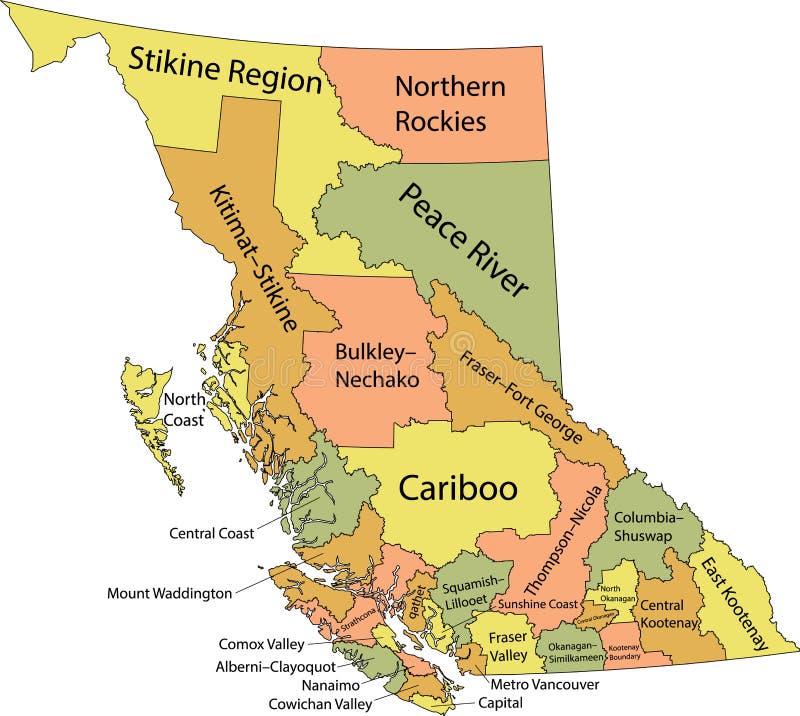
Free with trial Pastel flat vector administrative map of Canadian province of BRITISH COLUMBIA, CANADA with black border lines and name tags of its regional districts. Maple map vectors Pastel tagged administrative map of BRITISH COLUMBIA, CANADA. Pastel flat vector administrative map of Canadian province of BRITISH COLUMBIA, CANADA with black. Pastel flat vector administrative map of Canadian province of BRITISH COLUMBIA, CANADA with black border lines and name tags of its regional districts
Free with trial Black flat blank highlighted location map of the RANKIN INLET NORTH-CHESTERFIELD INLET District inside gray administrative map of the territorial electoral districts of Canadian territory of Nunavut,. Maple map vectors Location map of the ANKIN INLET NORTH-CHESTERFIELD INLET District. Black flat blank highlighted location map of the RANKIN INLET NORTH-CHESTERFIELD INLET. Black flat blank highlighted location map of the RANKIN INLET NORTH-CHESTERFIELD INLET District inside gray administrative map of the territorial electoral districts of Canadian territory of Nunavut,
Free with trial Map, Location, Canada, Leaf Blue Dotted Line Line Icon. Maple map vectors Map, Location, Canada, Leaf Blue Dotted Line Line Icon
Free with trial Black flat blank highlighted location map of the COUNTY OF NORTHERN LIGHTS municipal district inside gray administrative map of the Canadian province of Alberta, Canada. Maple map vectors Locator map of the COUNTY OF NORTHERN LIGHTS municipal district. Black flat blank highlighted location map of the COUNTY OF NORTHERN LIGHTS municipal district. Black flat blank highlighted location map of the COUNTY OF NORTHERN LIGHTS municipal district inside gray administrative map of the Canadian province of Alberta, Canada
Free with trial Black flat blank highlighted location map of the COUNTY OF FORTY MILE NO. 8 municipal district inside gray administrative map of the Canadian province of Alberta, Canada. Maple map vectors Locator map of the COUNTY OF FORTY MILE NO. 8 municipal district. Black flat blank highlighted location map of the COUNTY OF FORTY MILE NO. 8 municipal district. Black flat blank highlighted location map of the COUNTY OF FORTY MILE NO. 8 municipal district inside gray administrative map of the Canadian province of Alberta, Canada
Free with trial Black flat blank highlighted location map of the HALDIMAND COUNTY single-tier municipality inside gray administrative map of the Canadian province of Ontario, Canada. Maple map vectors Locator map of the HALDIMAND COUNTY single-tier municipality. Black flat blank highlighted location map of the HALDIMAND COUNTY single-tier municipality inside. Black flat blank highlighted location map of the HALDIMAND COUNTY single-tier municipality inside gray administrative map of the Canadian province of Ontario, Canada
Free with trial Black flat blank highlighted location map of the COUNTY OF TWO HILLS NO. 21 municipal district inside gray administrative map of the Canadian province of Alberta, Canada. Maple map vectors Locator map of the COUNTY OF TWO HILLS NO. 21 municipal district. Black flat blank highlighted location map of the COUNTY OF TWO HILLS NO. 21 municipal district. Black flat blank highlighted location map of the COUNTY OF TWO HILLS NO. 21 municipal district inside gray administrative map of the Canadian province of Alberta, Canada
Free with trial Black flat blank highlighted location map of the MACKENZIE COUNTY specialized municipality inside gray administrative map of the Canadian province of Alberta, Canada. Maple map vectors Locator map of the MACKENZIE COUNTY specialized municipality. Black flat blank highlighted location map of the MACKENZIE COUNTY specialized municipality inside. Black flat blank highlighted location map of the MACKENZIE COUNTY specialized municipality inside gray administrative map of the Canadian province of Alberta, Canada
Free with trial Black flat blank highlighted location map of the COUNTY OF VERMILION RIVER municipal district inside gray administrative map of the Canadian province of Alberta, Canada. Maple map vectors Locator map of the COUNTY OF VERMILION RIVER municipal district. Black flat blank highlighted location map of the COUNTY OF VERMILION RIVER municipal district. Black flat blank highlighted location map of the COUNTY OF VERMILION RIVER municipal district inside gray administrative map of the Canadian province of Alberta, Canada
Free with trial Map of canada. Vector illustration decorative background design. Conceptual vector. Maple map vectors Map of canada. Vector illustration decorative background design. Conceptual vector
Free with trial Black flat blank highlighted location map of the COUNTY OF WETASKIWIN NO. 10 municipal district inside gray administrative map of the Canadian province of Alberta, Canada. Maple map vectors Locator map of the COUNTY OF WETASKIWIN NO. 10 municipal district. Black flat blank highlighted location map of the COUNTY OF WETASKIWIN NO. 10 municipal. Black flat blank highlighted location map of the COUNTY OF WETASKIWIN NO. 10 municipal district inside gray administrative map of the Canadian province of Alberta, Canada
Free with trial Black flat blank highlighted location map of the COUNTY OF PAINTEARTH NO. 18 municipal district inside gray administrative map of the Canadian province of Alberta, Canada. Maple map vectors Locator map of the COUNTY OF PAINTEARTH NO. 18 municipal district. Black flat blank highlighted location map of the COUNTY OF PAINTEARTH NO. 18 municipal. Black flat blank highlighted location map of the COUNTY OF PAINTEARTH NO. 18 municipal district inside gray administrative map of the Canadian province of Alberta, Canada
Free with trial Black flat blank highlighted location map of the NORTHERN SUNRISE COUNTY municipal district inside gray administrative map of the Canadian province of Alberta, Canada. Maple map vectors Locator map of the NORTHERN SUNRISE COUNTY municipal district. Black flat blank highlighted location map of the NORTHERN SUNRISE COUNTY municipal district inside. Black flat blank highlighted location map of the NORTHERN SUNRISE COUNTY municipal district inside gray administrative map of the Canadian province of Alberta, Canada
Free with trial Black flat blank highlighted location map of the STRATHCONA COUNTY specialized municipality inside gray administrative map of the Canadian province of Alberta, Canada. Maple map vectors Locator map of the STRATHCONA COUNTY specialized municipality. Black flat blank highlighted location map of the STRATHCONA COUNTY specialized municipality inside. Black flat blank highlighted location map of the STRATHCONA COUNTY specialized municipality inside gray administrative map of the Canadian province of Alberta, Canada
Free with trial Canada flag on map on transparent background. Vector. Maple map vectors Canada flag on map on transparent background. Vector
Free with trial Location of Canada on the World Map with Enlarged Map of Canada with Flag. Geographical Vector Template for your design. Maple map vectors Location of Canada on the World Map with Enlarged Map of Canada with Flag. Geographical Vector Template for your design
Free with trial White flat blank vector administrative map of the regions of Canadian territory of NORTHWEST TERRITORIES, CANADA with black border lines of its regions. Maple map vectors White map of regions of NORTHWEST TERRITORIES, CANADA. White flat blank vector administrative map of the regions of Canadian territory of NORTHWEST TERRITORIES. White flat blank vector administrative map of the regions of Canadian territory of NORTHWEST TERRITORIES, CANADA with black border lines of its regions
Free with trial Set line Location with leaf Jam jar Canadian maple and Leaf icon. Vector. Maple map vectors Set line Location with leaf, Jam jar, Canadian maple and Leaf icon. Vector. Set line Location with leaf Jam jar Canadian maple and Leaf icon. Vector. Set line Location with leaf Jam jar Canadian maple and Leaf icon. Vector.
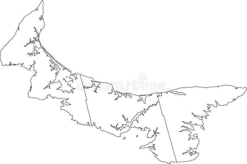
Free with trial White flat blank vector administrative map of the counties of Canadian province of PRINCE EDWARD ISLAND, CANADA with black border lines of its counties. Maple map vectors White map of counties of PRINCE EDWARD ISLAND, CANADA. White flat blank vector administrative map of the counties of Canadian province of PRINCE EDWARD ISLAND. White flat blank vector administrative map of the counties of Canadian province of PRINCE EDWARD ISLAND, CANADA with black border lines of its counties
Free with trial Topographic negative relief map of the Canadian province of BRITISH COLUMBIA, CANADA with white contour lines on dark gray background. Maple map vectors Topographic relief map of BRITISH COLUMBIA, CANADA. Topographic negative relief map of the Canadian province of BRITISH COLUMBIA, CANADA with white contour lines. Topographic negative relief map of the Canadian province of BRITISH COLUMBIA, CANADA with white contour lines on dark gray background
Free with trial Browser window with map of Canada, searching Canada in internet. Modern browser window template. Maple map vectors Browser window with map of Canada, searching Canada in internet. Modern browser window template
Free with trial Black flat blank highlighted location map of the LAC LA BICHE COUNTY specialized municipality inside gray administrative map of the Canadian province of Alberta, Canada. Maple map vectors Locator map of the LAC LA BICHE COUNTY specialized municipality. Black flat blank highlighted location map of the LAC LA BICHE COUNTY specialized municipality. Black flat blank highlighted location map of the LAC LA BICHE COUNTY specialized municipality inside gray administrative map of the Canadian province of Alberta, Canada
Free with trial Black flat blank highlighted location map of the LESSER SLAVE RIVER NO. 124 municipal district inside gray administrative map of the Canadian province of Alberta, Canada. Maple map vectors Locator map of the LESSER SLAVE RIVER NO. 124 municipal district. Black flat blank highlighted location map of the LESSER SLAVE RIVER NO. 124 municipal district. Black flat blank highlighted location map of the LESSER SLAVE RIVER NO. 124 municipal district inside gray administrative map of the Canadian province of Alberta, Canada
Free with trial Location of Canada on the world map, marked with Canada flag pin. Cartographic vector illustration. Maple map vectors Location of Canada on the world map, marked with Canada flag pin. Cartographic vector illustration
Free with trial Global Maple Logo. Canadian Red Maple With Global Earth Logo. Template Vector. Maple map vectors Global Maple Logo. Canadian Red Maple With Global Earth Logo. Template Vector
Free with trial Global Maple logo. Canadian Red Maple with Global earth logo. Sign template. Maple map vectors Global Maple logo. Canadian Red Maple with Global earth logo. Sign template
Free with trial Map, Canada, Leaf Blue Dotted Line Line Icon. Maple map vectors Map, Canada, Leaf Blue Dotted Line Line Icon
Free with trial Black flat blank highlighted location map of the COUNTY OF GRANDE PRAIRIE NO. 1 municipal district inside gray administrative map of the Canadian province of Alberta, Canada. Maple map vectors Locator map of the COUNTY OF GRANDE PRAIRIE NO. 1 municipal district. Black flat blank highlighted location map of the COUNTY OF GRANDE PRAIRIE NO. 1 municipal. Black flat blank highlighted location map of the COUNTY OF GRANDE PRAIRIE NO. 1 municipal district inside gray administrative map of the Canadian province of Alberta, Canada
Free with trial Black flat blank highlighted location map of the UNITED COUNTIES OF STORMONT, DUNDAS AND GLENGARRY inside gray administrative map of the Canadian province of Ontario, Canada. Maple map vectors Locator map of the UNITED COUNTIES OF STORMONT, DUNDAS AND GLENGARRY. Black flat blank highlighted location map of the UNITED COUNTIES OF STORMONT, DUNDAS AND. Black flat blank highlighted location map of the UNITED COUNTIES OF STORMONT, DUNDAS AND GLENGARRY inside gray administrative map of the Canadian province of Ontario, Canada
Free with trial Black flat blank highlighted location map of the PRINCE EDWARD COUNTY single-tier municipality inside gray administrative map of the Canadian province of Ontario, Canada. Maple map vectors Locator map of the PRINCE EDWARD COUNTY single-tier municipality. Black flat blank highlighted location map of the PRINCE EDWARD COUNTY single-tier municipality. Black flat blank highlighted location map of the PRINCE EDWARD COUNTY single-tier municipality inside gray administrative map of the Canadian province of Ontario, Canada
Free with trial Pastel flat vector administrative map of the territorial electoral districts of Canadian territory of NUNAVUT, CANADA with black border lines and name tags of its districts. Maple map vectors Pastel map of the territorial electoral districts of NUNAVUT, CANADA. Pastel flat vector administrative map of the territorial electoral districts of Canadian. Pastel flat vector administrative map of the territorial electoral districts of Canadian territory of NUNAVUT, CANADA with black border lines and name tags of its districts
Free with trial Black flat blank highlighted location map of the PROVOST NO. 52 municipal district inside gray administrative map of the Canadian province of Alberta, Canada. Maple map vectors Locator map of the PROVOST NO. 52 municipal district. Black flat blank highlighted location map of the PROVOST NO. 52 municipal district inside gray. Black flat blank highlighted location map of the PROVOST NO. 52 municipal district inside gray administrative map of the Canadian province of Alberta, Canada
Free with trial Black flat blank highlighted location map of the PROVOST NO. 52 municipal district inside gray administrative map of the Canadian province of Alberta, Canada. Maple map vectors Locator map of the PROVOST NO. 52 municipal district. Black flat blank highlighted location map of the PROVOST NO. 52 municipal district inside gray. Black flat blank highlighted location map of the PROVOST NO. 52 municipal district inside gray administrative map of the Canadian province of Alberta, Canada
 Sign in