Free with trial Abstract mountain landscape illustration. Wavy contour lines create depth and texture. Nature, geography, and topographic design concept. Minimalist line art drawing background. Mapping vectors Abstract mountain landscape illustration. Wavy contour lines create depth and texture. Nature, geography, and. Topographic design concept. Minimalist line art
Free with trial Nigeria map with borders, cities, capital and administrative divisions. Infographic vector map. Editable layers clearly labeled. Mapping vectors Nigeria infographic map vector illustration. Nigeria map with borders, cities, capital and administrative divisions. Infographic vector map. Editable layers. Nigeria map with borders, cities, capital and administrative divisions. Infographic vector map. Editable layers clearly labeled.
Free with trial Paper white silhouette of human head, linear pictograms and text boxes connected to it by lines. Concept of mind map or scheme. Creative infographic design template. Vector illustration for brochure. Mapping vectors Modern Infographic Template. Paper white silhouette of human head, linear pictograms and text boxes connected to it by lines. Concept of mind map or scheme. Paper white silhouette of human head, linear pictograms and text boxes connected to it by lines. Concept of mind map or scheme. Creative infographic design template. Vector illustration for brochure.
Free with trial Metropolis of Greater Paris administrative and political vector map. Mapping vectors Metropolis of Greater Paris administrative and political vector map.
Free with trial Colorful Africa political map with clearly labeled, separated layers. Vector illustration. Mapping vectors Colorful Africa political map with clearly labeled, separated layers. Vector illustration
Free with trial Road vector map of the brazilian state mato grosso do sul. Mapping vectors Road map of the brazilian state mato grosso do sul. Road vector map of the brazilian state mato grosso do sul. Road vector map of the brazilian state mato grosso do sul.
Free with trial Hurghada and vicinity, Egypt, gray political map. City area in the Red Sea Governorate of Egypt, and one of the main tourist centres of the country, located on the Red Sea coast with numerous resorts. Mapping vectors Hurghada, tourist centres on Red Sea coast in Egypt, gray political map. Hurghada and vicinity, Egypt, gray political map. City area in the Red Sea Governorate. Hurghada and vicinity, Egypt, gray political map. City area in the Red Sea Governorate of Egypt, and one of the main tourist centres of the country, located on the Red Sea coast with numerous resorts.
Free with trial Mesoamerica, gray political map. Historical region and cultural area in southern North America and Central America, from Mexico to Costa Rica. Within this region pre Columbian societies flourished. Mapping vectors Mesoamerica, gray political map, pre Columbian region and cultural area. Mesoamerica, gray political map. Historical region and cultural area in southern North. Mesoamerica, gray political map. Historical region and cultural area in southern North America and Central America, from Mexico to Costa Rica. Within this region pre Columbian societies flourished.
Free with trial Ionian Islands Region of Greece, gray political map. Greek island group in the Ionian Sea. Corfu (Kerkyra), Paxos and Antipaxos, Lefkada, Kefalonia (Cephalonia), Ithaca (Ithaki) and Zakynthos (Zante). Mapping vectors Ionian Islands Region of Greece, Greek island group, gray political map. Ionian Islands Region of Greece, gray political map. Greek island group in the Ionian. Ionian Islands Region of Greece, gray political map. Greek island group in the Ionian Sea. Corfu (Kerkyra), Paxos and Antipaxos, Lefkada, Kefalonia (Cephalonia), Ithaca (Ithaki) and Zakynthos (Zante).
Free with trial Kuril Islands, gray political map. A volcanic archipelago part of Sakhalin Oblast in Russian Far East. Stretches from Hokkaido in Japan to Kamchatka Peninsula in Russia. Under Russian administration. Mapping vectors Kuril Islands, from Hokkaido to Kamchatka Peninsula, gray political map. Kuril Islands, gray political map. A volcanic archipelago part of Sakhalin Oblast in. Kuril Islands, gray political map. A volcanic archipelago part of Sakhalin Oblast in Russian Far East. Stretches from Hokkaido in Japan to Kamchatka Peninsula in Russia. Under Russian administration.
Free with trial Set of 330 Digital Marketing web icons in line style. Social, networks, feedback, communication, marketing, ecommerce. Vector. Illustration. Mapping vectors Set of 330 Digital Marketing web icons in line style. Social, networks, feedback, communication, marketing, ecommerce. Vector. Illustration
Free with trial Hierarchical diagram with place for person`s photo in center connected to text boxes by coloful lines. Concept of personal mind map or scheme. Flat infographic design template. Vector illustration. Mapping vectors Infographic design template. Hierarchical diagram with place for person`s photo in center connected to text boxes by coloful lines. Concept of personal mind map. Hierarchical diagram with place for person`s photo in center connected to text boxes by coloful lines. Concept of personal mind map or scheme. Flat infographic design template. Vector illustration.
Free with trial Mind map, intersected colorful translucent circular elements with thin line pictograms inside. Concept of schematic representation of information. Infographic design template. Vector illustration. Mapping vectors Infographic design template. Mind map, intersected colorful translucent circular elements with thin line pictograms inside. Concept of schematic representation. Mind map, intersected colorful translucent circular elements with thin line pictograms inside. Concept of schematic representation of information. Infographic design template. Vector illustration.
Free with trial Thermographic heatmap background with vibrant temperature spectrum colors. Abstract data visualization design suitable for analytics dashboards, AI systems, scientific research. Mapping vectors Thermographic Heatmap Data Visualization Background. Thermographic heatmap background with vibrant temperature spectrum colors. Abstract data visualization. Thermographic heatmap background with vibrant temperature spectrum colors. Abstract data visualization design suitable for analytics dashboards, AI systems, scientific research
Free with trial High detailed Spain road map with labeling. Vector illustration. Mapping vectors High detailed Spain road map with labeling. Vector illustration
Free with trial High detailed Spain road map with labeling. Vector illustration. Mapping vectors High detailed Spain road map with labeling. Vector illustration
Free with trial High detailed Japan road map with labeling. Vector illustration. Mapping vectors High detailed Japan road map with labeling. Vector illustration
Free with trial High detailed China road map with labeling. Vector illustration. Mapping vectors High detailed China road map with labeling. Vector illustration
Free with trial Caribbean islands map, island with names, color map isolated on white background. Vector. Mapping vectors Caribbean islands map, island with names, color map isolated on white background. Vector
Free with trial Vector map of the australian island tasmania. Mapping vectors Vector map of the australian island tasmania.
Free with trial Stylized map of Peru. Isometric 3D green map with cities, borders, capital Lima, regions. Vector illustration. Editable layers clearly labeled. English language. Mapping vectors Stylized map of Peru. Isometric 3D green map. With cities, borders, capital Lima, regions. Vector illustration. Editable layers clearly labeled. English
Free with trial Detailed physical vector map of the French republic. Mapping vectors Detailed physical vector map of the French republic.
Free with trial Colorful Poland political map with clearly labeled, separated layers. Vector illustration. Mapping vectors Colorful Poland political map with clearly labeled, separated layers. Vector illustration
Free with trial Imaginary volcanic island map with coast and rivers. Mapping vectors Imaginary volcanic island map with coast and rivers. Imaginary volcanic island vector map with coast and rivers
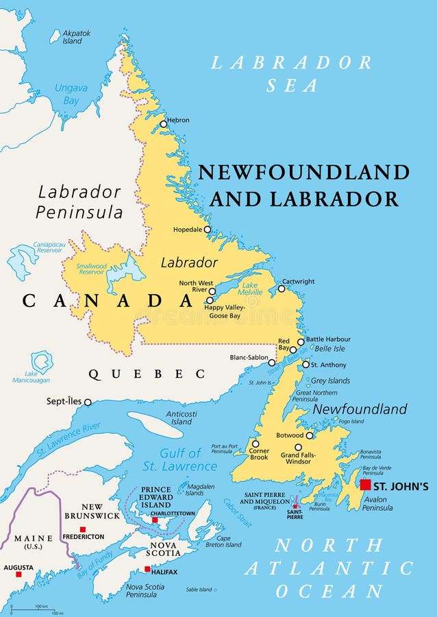
Free with trial Newfoundland and Labrador,political map. Province of Canada,in the Atlantic region,with capital St. Johns. Island of Newfoundland and continental region of Labrador between Quebec and the Atlantic. Mapping vectors Newfoundland and Labrador, easternmost province of Canada, political map. Newfoundland and Labrador,political map. Province of Canada,in the Atlantic region,with. Newfoundland and Labrador,political map. Province of Canada,in the Atlantic region,with capital St. Johns. Island of Newfoundland and continental region of Labrador between Quebec and the Atlantic.
Free with trial Jan Mayen,gray political map. Norwegian volcanic island in Arctic Ocean between Greenland and Norwegian Sea,partly covered with glaciers around Beerenberg volcano. Largest settlement is Olonkinbyen. Mapping vectors Jan Mayen, Norwegian volcanic island in Arctic Ocean, gray political map. Jan Mayen,gray political map. Norwegian volcanic island in Arctic Ocean between. Jan Mayen,gray political map. Norwegian volcanic island in Arctic Ocean between Greenland and Norwegian Sea,partly covered with glaciers around Beerenberg volcano. Largest settlement is Olonkinbyen.
Free with trial African Great Lakes region,gray political map. Large rift lakes of Africa,and their riparian countries with capitals and borders. Lake Victoria,Lake Tanganyika,Lake Malawi and smaller lakes. Mapping vectors African Great Lakes region, the large rift lakes of Africa, gray political map. African Great Lakes region,gray political map. Large rift lakes of Africa,and. African Great Lakes region,gray political map. Large rift lakes of Africa,and their riparian countries with capitals and borders. Lake Victoria,Lake Tanganyika,Lake Malawi and smaller lakes.
Free with trial High detailed Africa road map with labeling. High detailed Africa road and highway map with labeling. Vector illustration. Mapping vectors High detailed Africa road map with labeling. High detailed Africa road and highway map with labeling. Vector illustration
Free with trial Stylized vector Kazakhstan map showing big cities, capital Astana, administrative divisions. Mapping vectors Kazakhstan map with administrative divisions. Stylized vector Kazakhstan map showing big cities, capital Astana, administrative divisions. Stylized vector Kazakhstan map showing big cities, capital Astana, administrative divisions.
Free with trial Conceptual illustration of a woman sitting on her own head and doing meditation. Concepts for mindful meditation. Mapping vectors Conceptual illustration of a woman sitting on her own head and doing meditation. Concepts for mindful meditation
Free with trial Road vector map of the brazilian state espirito santo. Mapping vectors Road vector map of the brazilian state espirito santo.
Free with trial This blank political map features the outline of North America, showing the continents without labels or colors. It is ideal for educational purposes, planning, and geographic analysis. Mapping vectors Blank political vector map of North America. This blank political map features the outline of North America, showing the continents without labels or colors. It. This blank political map features the outline of North America, showing the continents without labels or colors. It is ideal for educational purposes, planning, and geographic analysis.
Free with trial France - Highly detailed editable political map with labeling. Vector illustration. Mapping vectors France - Highly detailed editable political map with labeling. Vector illustration
Free with trial The Inca Empire at its greatest extent,about 1525,political map. Also known as Incan or Inka Empire,with capital Cusco. Called Tawantinsuyu by its subjects,Quechua for the Realm of the Four Parts. Mapping vectors The Inca Empire at its greatest extent, with capital Cuzco, political map. The Inca Empire at its greatest extent,about 1525,political map. Also known as Incan. The Inca Empire at its greatest extent,about 1525,political map. Also known as Incan or Inka Empire,with capital Cusco. Called Tawantinsuyu by its subjects,Quechua for the Realm of the Four Parts.
Free with trial DNA test, Genom map. Graphic concept for your design. Mapping vectors DNA test, Genom map. Graphic concept for your design
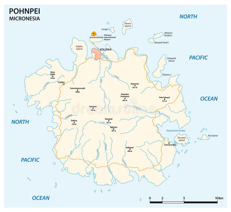
Free with trial Vector road map of the main Micronesian island of Pohnpei. Mapping vectors Vector road map of the main Micronesian island of Pohnpei.
Free with trial Vector road map of the main Micronesian island of Pohnpei. Mapping vectors Vector road map of the main Micronesian island of Pohnpei.
Free with trial Map of Nantucket Iceland in the US state of Massachusetts. Mapping vectors Map of Nantucket Iceland in the US state of Massachusetts. Vector map of Nantucket Iceland in the US state of Massachusetts
Free with trial Rubber Ball with Star isoalted. Vector. Illustration. Mapping vectors Rubber Ball with Star isoalted. Vector. Illustration
Free with trial Map of the state Saxony with the most important cities in german language. Mapping vectors Map of the state Saxony with the most important cities in german language.
Free with trial Isometric 3D Saudi Arabia map. Stylized vector map illustration with cities, borders, capital, administrative divisions and pointer marks; gradient background with grid. Mapping vectors Isometric Saudi Arabia map with city names and administrative di. Isometric 3D Saudi Arabia map. Stylized vector map illustration with cities, borders, capital. Isometric 3D Saudi Arabia map. Stylized vector map illustration with cities, borders, capital, administrative divisions and pointer marks; gradient background with grid.
Free with trial Vector population map of the People s Republic of China. Mapping vectors Vector population map of the People s Republic of China.
Free with trial USA map silhouette. Black and white concept. vector illustration. Mapping vectors USA map. Silhouette. Black and white concept. vector illustration
Free with trial High detailed Hungary road map with labeling. Vector illustration. Mapping vectors High detailed Hungary road map with labeling. Vector illustration
Free with trial High detailed Ireland road map with labeling. Vector illustraton. Mapping vectors High detailed Ireland road map with labeling. Vector illustraton
Free with trial Scientific Process Icon Set with Web Header Banner. Mapping vectors Scientific Process Icon Set with Web Header Banner. Scientific Process Icon Set & Web Header Banner
Free with trial Isometric 3D Greece map, vector illustration with cities, borders, capital, administrative divisions and pointer marks; gradient blue background. Concept for infographic. Mapping vectors Isometric 3D Greece vector map concept. Isometric 3D Greece map, vector illustration with cities, borders, capital, administrative divisions and pointer marks. Isometric 3D Greece map, vector illustration with cities, borders, capital, administrative divisions and pointer marks; gradient blue background. Concept for infographic.
Free with trial Large Hadron Collider LHC and Super Proton Synchrotron SPS, political map. Position of worlds largest and highest-energy particle collider near Geneva beneath the border of France and Switzerland. Mapping vectors Large Hadron Collider LHC and Super Proton Synchrotron SPS, political map. Position of worlds largest and highest-energy particle collider near Geneva beneath
Free with trial Colorful United Arab Emirates political map with clearly labeled, separated layers. Vector illustration. Mapping vectors Colorful United Arab Emirates political map with clearly labeled, separated layers. Vector illustration
Free with trial Switzerland map with borders, cities, capital and administrative divisions. Infographic vector map. Editable layers clearly labeled. Mapping vectors Switzerland infographic map vector illustration. Switzerland map with borders, cities, capital and administrative divisions. Infographic vector map. Editable. Switzerland map with borders, cities, capital and administrative divisions. Infographic vector map. Editable layers clearly labeled.
Free with trial Andhra Pradesh administrative and political map, India. Mapping vectors Andhra Pradesh administrative and political map, India.
Free with trial A clean and modern United States map set featuring outline, solid silhouette, circular line, and dot pattern styles. Suitable for geography projects, presentations, educational materials, data visualization, web layouts, and editorial design use. Mapping vectors United States Map Set with Outline, Solid Silhouette, Circular Line and Dot Pattern Design. A clean and modern United States map set featuring outline, solid. A clean and modern United States map set featuring outline, solid silhouette, circular line, and dot pattern styles. Suitable for geography projects, presentations, educational materials, data visualization, web layouts, and editorial design use.
Free with trial High detailed Africa road and highway map with labeling. Vector illustration. Mapping vectors High detailed Africa road map with labeling. High detailed Africa road and highway map with labeling. Vector illustration. High detailed Africa road and highway map with labeling. Vector illustration.
Free with trial Striped ball. 3d Sphere with Texture. Ball isolated on white background. Vector. Illustration. Mapping vectors Striped ball. 3d Sphere with Texture. Ball isolated on white background. Vector. Illustration
Free with trial Continent Asia. art earth globe. Vector Illustration. Mapping vectors Continent Asia. Art earth globe. Vector Illustration
Free with trial Democratic Socialist Republic of Sri Lanka Railway map. Mapping vectors Democratic Socialist Republic of Sri Lanka Railway map.
Free with trial Georgia, gray political map, with capital Tbilisi, and international borders. Republic and transcontinental country in Eurasia, located south of North Caucasus Federal District of Russia. Illustration. Mapping vectors Georgia, gray political map, with capital Tbilisi, and international borders. Republic and transcontinental country in Eurasia, located south of North Caucasus
Free with trial Tasmania and the surrounding area, political map. Australian island state with capital Hobart, south of state Victoria and of Australian mainland, encompassing island Tasmania and surrounding islands. Mapping vectors Tasmania and the surrounding area, island state of Australia, political map. Tasmania and the surrounding area, political map. Australian island state with. Tasmania and the surrounding area, political map. Australian island state with capital Hobart, south of state Victoria and of Australian mainland, encompassing island Tasmania and surrounding islands.
Free with trial High detailed Netherlands physical map. Vector illustration. Mapping vectors High detailed Netherlands physical map. Vector illustration
Free with trial High detailed Netherlands physical map. Vector illustration. Mapping vectors High detailed Netherlands physical map. Vector illustration
Free with trial High detailed Netherlands physical map. Vector illustration. Mapping vectors High detailed Netherlands physical map. Vector illustration
Free with trial Map downtown Manhattan World Trade Center, New York City. United Staes. Mapping vectors Map downtown Manhattan World Trade Center, New York City. United Staes
Free with trial Stylized vector Myanmar Burma map showing big cities, capital Naypyidaw, administrative divisions. Mapping vectors Myanmar Burma map with administrative divisions. Stylized vector Myanmar Burma map showing big cities, capital Naypyidaw, administrative divisions. Stylized vector Myanmar Burma map showing big cities, capital Naypyidaw, administrative divisions.
Free with trial Oklahoma state outline administrative and political vector map in color. Mapping vectors Oklahoma state outline administrative and political vector map in color.
Free with trial Abstract vector landscape background. Cyberspace grid. 3d technology vector illustration. Mapping vectors Abstract vector landscape background. Cyberspace grid. 3d technology vector illustration
Free with trial Colorful Bogota administrative and political vector map. Mapping vectors Colorful Bogota administrative and political vector map.
Free with trial India map silhouette. Black and white concept. vector illustration. Mapping vectors India map. Silhouette. Black and white concept. vector illustration
Free with trial High detailed China physical map with labeling. Vector illustration. Mapping vectors High detailed China physical map with labeling. Vector illustration
Free with trial High detailed Brazil physical map. Clearly labeled, separated layers, vector illustration. Mapping vectors High detailed Brazil physical map with labeling. High detailed Brazil physical map. Clearly labeled, separated layers, vector illustration. High detailed Brazil physical map. Clearly labeled, separated layers, vector illustration.
Free with trial Ukraine map administrative division separate regions with names color map isolated on white background. Vector. Mapping vectors Ukraine map administrative division separate regions with names color map isolated on white background. Vector
Free with trial Vector population map of the Federative Republic of Brazil. Mapping vectors Vector population map of the Federative Republic of Brazil.
Free with trial Colorful Galicia administrative and political vector map. Mapping vectors Colorful Galicia administrative and political vector map.
Free with trial The Guianas, also Guyanas or Guayanas, political map. Region in north-eastern South America compromising the Guayana Region of Venezuela, Guyana, Suriname, French Guiana and the Amapa state of Brazil. Mapping vectors The Guianas, also Guyanas or Guayanas, region in South America, political map. The Guianas, also Guyanas or Guayanas, political map. Region in north-eastern. The Guianas, also Guyanas or Guayanas, political map. Region in north-eastern South America compromising the Guayana Region of Venezuela, Guyana, Suriname, French Guiana and the Amapa state of Brazil.
Free with trial Saudi Arabia map with borders, cities, capital and administrative divisions. Infographic vector map. Editable layers clearly labeled. Mapping vectors Saudi Arabia infographic map vector illustration. Saudi Arabia map with borders, cities, capital and administrative divisions. Infographic vector map. Editable. Saudi Arabia map with borders, cities, capital and administrative divisions. Infographic vector map. Editable layers clearly labeled.
Free with trial Vector road map of the greek mediterranean island of Rhodes. Mapping vectors Vector road map of the greek mediterranean island of Rhodes.
Free with trial Brazil map silhouette. Black and white concept. vector illustration. Mapping vectors Brazil map. Silhouette. Black and white concept. vector illustration
Free with trial High detailed Hawaii physical map with labeling. Vector illustration. Mapping vectors High detailed Hawaii physical map with labeling. Vector illustration
Free with trial High detailed Mexico physical map with labeling. Vector illustration. Mapping vectors High detailed Mexico physical map with labeling. Vector illustration
Free with trial High detailed Canada physical map with labeling. Vector. Mapping vectors High detailed Canada physical map with labeling. Vector
Free with trial High detailed Canada physical map with labeling. Vector illustration. Mapping vectors High detailed Canada physical map with labeling. Vector illustration
 Sign in