Free with trial Stylized vector Puerto Rico map showing big cities, capital San Juan, administrative divisions. Mapping vectors Puerto Rico map with administrative divisions. Stylized vector Puerto Rico map showing big cities, capital San Juan, administrative divisions. Stylized vector Puerto Rico map showing big cities, capital San Juan, administrative divisions.
Free with trial Roads, political and administrative map of the Western United States of America. Mapping vectors Roads, political and administrative map of the Western United States of America.
Free with trial World map vector background. Art earth globe. Vector Illustration. Mapping vectors World map vector background. Art earth globe. Vector Illustration
Free with trial Malta map vector with red pin. Malta vector map. Editable template with regions, cities, red pins and blue surface on white background. Mapping vectors Malta map vector with red pin. Malta vector map. Editable template with regions, cities, red pins and blue surface on white background
Free with trial Vector set of Ecuador country. Isometric 3d map, Ecuador map, South America map - with region, state names and city names. Mapping vectors Vector set of Ecuador country. Isometric 3d map, Ecuador map, South America map - with region, state names and city names
Free with trial Constructor roads set. Flat road elements. Create your own isometric city road. Connectable road elements. Vector illustration. Mapping vectors Constructor roads set. Flat road elements. Create your own isometric city road. Connectable road elements. Vector illustration
Free with trial Belgium - Highly detailed editable political map with labeling. Vector illustration. Mapping vectors Belgium - Highly detailed editable political map with labeling. Vector illustration
Free with trial Isometric city map road, trees and building home elements set vector illustration. Mapping vectors Isometric city set. Isometric city map road, trees and building home elements set vector illustration. Isometric city map road, trees and building home elements set vector illustration.
Free with trial High detailed Norway physical map with labeling. Vector illustration. Mapping vectors High detailed Norway physical map with labeling. Vector illustration
Free with trial High detailed South America road map with labeling - Black. clearly labeled on separated layers. Mapping vectors High detailed South America road map with labeling - Black. Clearly labeled on separated layers
Free with trial Kansas state outline administrative and political vector map in black and white. Mapping vectors Kansas state outline administrative and political vector map in black and white.
Free with trial South Asian Association for Regional Cooperation SAARC vector map with logo. Mapping vectors South Asian Association for Regional Cooperation SAARC vector map with logo.
Free with trial States of Mexico,gray political map. The United Mexican States,a country in the southern portion of North America. Federal republic composed of autonomous entities and with the capital Mexico City. Mapping vectors States of Mexico, the United Mexican States, gray political map. States of Mexico,gray political map. The United Mexican States,a country in the southern portion. States of Mexico,gray political map. The United Mexican States,a country in the southern portion of North America. Federal republic composed of autonomous entities and with the capital Mexico City.
Free with trial Moldova and Transnistria, political map. Republic of Moldova, with capital Chisinau, and the Pridnestrovian Moldavian Republic, PMR, a disputed and unrecognized breakaway state, with capital Tiraspol. Mapping vectors Moldova and breakaway state Transnistria, political map. Moldova and Transnistria, political map. Republic of Moldova, with capital Chisinau, and the. Moldova and Transnistria, political map. Republic of Moldova, with capital Chisinau, and the Pridnestrovian Moldavian Republic, PMR, a disputed and unrecognized breakaway state, with capital Tiraspol.
Free with trial Island of Newfoundland, political map. Part of Canadian province of Newfoundland and Labrador with capital St. John`s. Large island off the coast of mainland North America southwest of Labrador Sea. Mapping vectors Island of Newfoundland, political map, part of Newfoundland and Labrador. Island of Newfoundland, political map. Part of Canadian province of Newfoundland and. Island of Newfoundland, political map. Part of Canadian province of Newfoundland and Labrador with capital St. John`s. Large island off the coast of mainland North America southwest of Labrador Sea.
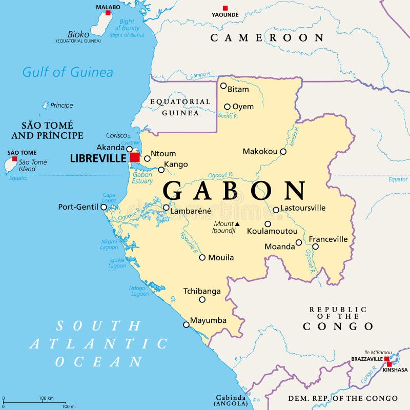
Free with trial Gabon,political map. Gabonese Republic,a country on the Atlantic coast of Central Africa,with capital Libreville. Bordered by Equatorial Guinea,Cameroon,Republic of the Congo,and Gulf of Guinea. Mapping vectors Gabon, the Gabonese Republic, a country in Central Africa, political map. Gabon,political map. Gabonese Republic,a country on the Atlantic coast of Central. Gabon,political map. Gabonese Republic,a country on the Atlantic coast of Central Africa,with capital Libreville. Bordered by Equatorial Guinea,Cameroon,Republic of the Congo,and Gulf of Guinea.
Free with trial Turkey map vector with red pin. Turkey vector map. Editable template with regions, cities, red pins and blue surface on white background. Mapping vectors Turkey map vector with red pin. Turkey vector map. Editable template with regions, cities, red pins and blue surface on white background
Free with trial Christmas Island, Australia, political map, with main settlement Flying Fish Cove. Australian external territory, comprising the island of same name, located in the Indian Ocean. Illustration. Vector. Mapping vectors Christmas Island, external territory of Australia, political map. Christmas Island, Australia, political map, with main settlement Flying Fish Cove. Australian. Christmas Island, Australia, political map, with main settlement Flying Fish Cove. Australian external territory, comprising the island of same name, located in the Indian Ocean. Illustration. Vector.
Free with trial Highway road view. Highway road top view from above with cars, buses and trucks. Mapping vectors Highway road view. Highway road top view from above with cars, buses and trucks
Free with trial Road vector map of the brazilian state bahia. Mapping vectors Road map of the brazilian state bahia. Road vector map of the brazilian state bahia. Road vector map of the brazilian state bahia.
Free with trial Panama map vector with red pin. Panama vector map. Editable template with regions, cities, red pins and blue surface on white background. Mapping vectors Panama map vector with red pin. Panama vector map. Editable template with regions, cities, red pins and blue surface on white background
Free with trial French Riviera,gray political map. Mediterranean coastline of the southeast corner of France,known as Cote dAzur or Azure Coast. Considered to extend from Toulon in the west to Menton in the east. Mapping vectors French Riviera, Cote dAzur, a Mediterranean coastline, gray political map. French Riviera,gray political map. Mediterranean coastline of the southeast corner of. French Riviera,gray political map. Mediterranean coastline of the southeast corner of France,known as Cote dAzur or Azure Coast. Considered to extend from Toulon in the west to Menton in the east.
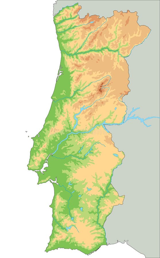
Free with trial High detailed Portugal physical map. Vector illustration. Mapping vectors High detailed Portugal physical map. Vector illustration
Free with trial National park and conservancy map of the Caprivi Strip in the north east of Namibia. Mapping vectors National park and conservancy map of the Caprivi Strip in the north east of Namibia.
Free with trial Spain - Highly detailed editable political map with separated layers. Vector illustration. Mapping vectors Spain - Highly detailed editable political map with separated layers. Vector illustration
Free with trial Stylized vector Saudi Arabia map showing big cities, capital Riyadh, administrative divisions. Mapping vectors Saudi Arabia map with administrative divisions. Stylized vector Saudi Arabia map showing big cities, capital Riyadh, administrative divisions. Stylized vector Saudi Arabia map showing big cities, capital Riyadh, administrative divisions.
Free with trial Colorful China political map with clearly labeled, separated layers. Vector illustration. Mapping vectors Colorful China political map with clearly labeled, separated layers. Vector illustration
Free with trial Vector map of scottish archipelago hebrides at the north west coast of scotland. Mapping vectors Vector map of scottish archipelago hebrides at the north west coast of scotland.
Free with trial Male geography teacher with pointer speaking explaining subject standing at hanged world map in classroom vector illustration. School lesson and education concept. Mapping vectors Male geography teacher standing at hanged world map in classroom. Male geography teacher with pointer speaking explaining subject standing at hanged world map in. Male geography teacher with pointer speaking explaining subject standing at hanged world map in classroom vector illustration. School lesson and education concept
Free with trial City map Dallas, color detailed plan, vector illustration. For design travel illustration. Mapping vectors City map Dallas, color detailed plan, vector illustration. For design travel illustration
Free with trial Vector set of Colombia country. Isometric 3d map, Colombia map, South America map - with region, state names and city names. Mapping vectors Vector set of Colombia country. Isometric 3d map, Colombia map, South America map - with region, state names and city names
Free with trial Vector map of Papua New Guinea. Country map with division, cities and capital Port Moresby. Political map, world map, infographic elements. Mapping vectors Vector map of Papua New Guinea. Country map with division, cities and capital Port Moresby. Political map, world map, infographic elements
Free with trial Business flowchart, process management diagram with businessmans and businesswomans characters. Vector illustration, isolated on white background. Mapping vectors Business flowchart, process management diagram with businessmans and businesswomans characters. Vector illustration on. Business flowchart, process management. Business flowchart, process management diagram with businessmans and businesswomans characters. Vector illustration, isolated on white background.
Free with trial Missouri state outline administrative and political vector map in black and white. Mapping vectors Missouri state outline administrative and political vector map in black and white.
Free with trial Water map of the African country Namibia. Mapping vectors Water map of the African country Namibia.
Free with trial Asia map, separates individual states with names, color map isolated on white background. Vector. Mapping vectors Asia map, separates individual states with names, color map isolated on white background. Vector
Free with trial New Zealand - Highly detailed editable political map with labeling. Vector illustration. Mapping vectors New Zealand - Highly detailed editable political map with labeling. Vector illustration
Free with trial Stylized vector Australia map showing big cities, capital Canberra, administrative divisions. Mapping vectors Stylized vector Australia map. Showing big cities, capital Canberra, administrative divisions
Free with trial Political map of Europe in gray color with white background and the names of the countries in Spanish. Vector illustration. Mapping vectors Political map of Europe in gray color with white background and the names of the countries in Spanish. Vector illustration
Free with trial Colorful Sweden political map with clearly labeled, separated layers. Vector illustration. Mapping vectors Colorful Sweden political map with clearly labeled, separated layers. Vector illustration
Free with trial Map of Timor Island, East Timor and Indonesia. Mapping vectors Map of Timor Island, East Timor and Indonesia.
Free with trial Highly detailed editable political map with separated layers. Mexico. Vector illustration. Mapping vectors Highly detailed editable political map with separated layers. Mexico. Vector illustration
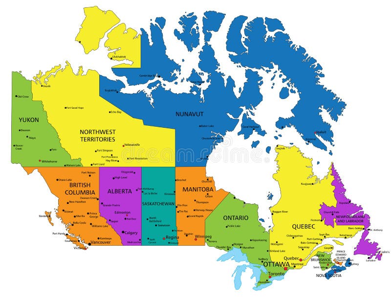
Free with trial Colorful Canada political map with clearly labeled, separated layers. Vector illustration. Mapping vectors Colorful Canada political map with clearly labeled, separated layers. Vector illustration
Free with trial Cuba road and national park vector map. Mapping vectors Cuba road and national park vector map.
Free with trial India map with selectable territories. Vector. Illustration. Mapping vectors India map with selectable territories. Vector. Illustration
Free with trial South Georgia, political map. Part of the British Overseas Territory of South Georgia and the South Sandwich Islands. Group of islands in the South Atlantic Ocean and Scotia Sea. Illustration. Vector. Mapping vectors South Georgia, political map, a British Overseas Territory. South Georgia, political map. Part of the British Overseas Territory of South Georgia and the South. South Georgia, political map. Part of the British Overseas Territory of South Georgia and the South Sandwich Islands. Group of islands in the South Atlantic Ocean and Scotia Sea. Illustration. Vector.
Free with trial Tokelau,dependant territory of New Zealand,political map. Archipelago in the South Pacific consisting of tropical coral atolls Atafu,Nukunonu and Fakaofo. The Swains Island is territorial disputed. Mapping vectors Tokelau, dependant territory of New Zealand, political map. Tokelau,dependant territory of New Zealand,political map. Archipelago in the South Pacific consisting. Tokelau,dependant territory of New Zealand,political map. Archipelago in the South Pacific consisting of tropical coral atolls Atafu,Nukunonu and Fakaofo. The Swains Island is territorial disputed.
Free with trial City map Kharkiv, color detailed plan, vector illustration. Roads, trails and rivers. Mapping vectors City map Kharkiv, color detailed plan, vector illustration. Roads, trails and rivers
Free with trial Vector map of malay island city penang. Mapping vectors Vector map of malay island city penang.
Free with trial A crisp, black and white vector illustration of a classic compass rose. The design features bold cardinal directions N, S, E, W, a prominent star-shaped pointer, and a detailed outer ring with markings. This iconic symbol represents navigation, guidance, and exploration. Ideal for projects related to travel, adventure, mapping, maritime themes, or as a timeless emblem for orientation and discovery. Its clean lines and high contrast make it versatile for various design applications, from logos to educational materials. Mapping vectors Black and White Compass Rose Navigation Icon. A crisp, black and white vector illustration of a classic compass rose. The design features bold cardinal. A crisp, black and white vector illustration of a classic compass rose. The design features bold cardinal directions N, S, E, W, a prominent star-shaped pointer, and a detailed outer ring with markings. This iconic symbol represents navigation, guidance, and exploration. Ideal for projects related to travel, adventure, mapping, maritime themes, or as a timeless emblem for orientation and discovery. Its clean lines and high contrast make it versatile for various design applications, from logos to educational materials.
Free with trial Vermont state outline administrative and political map in black and white. Mapping vectors Vermont state outline administrative and political map in black and white.
Free with trial High detailed Finland physical map Vector illustration. Mapping vectors High detailed Finland physical map. High detailed Finland physical map Vector illustration. High detailed Finland physical map Vector illustration.
Free with trial High detailed Romania physical map. Vector illustration. Mapping vectors High detailed Romania physical map. Vector illustration
Free with trial Mexico map with selectable territories. Vector. Illustration. Mapping vectors Mexico map with selectable territories. Vector. Illustration
Free with trial Vector set of Thailand country. Isometric 3d map, Thailand map, Asia map - with region, state names and city names. Mapping vectors Vector set of Thailand country. Isometric 3d map, Thailand map, Asia map - with region, state names and city names
Free with trial Texas state map with neighboring states. Mapping vectors Texas state map with neighboring states.
Free with trial Vector map of the Capitale Nationale Quebec administrative region, Canada. Mapping vectors Vector map of the Capitale Nationale Quebec administrative region, Canada.
Free with trial India - Highly detailed editable political map with labeling. Vector illustron. Mapping vectors India - Highly detailed editable political map with labeling. Vector illustron
Free with trial Wisconsin state outline administrative and political vector map in black and white. Mapping vectors Wisconsin state outline administrative and political vector map in black and white.
Free with trial South africa road and National Park map. Mapping vectors South africa road and National Park map.
Free with trial Road map of mediterranean island cyprus. Mapping vectors Road map of mediterranean island cyprus.
Free with trial Belgium map Provinces of Belgium color map isolated on white background. Vector. Mapping vectors Belgium map Provinces of Belgium color map isolated on white background. Vector
Free with trial Saint Helena, Ascension and Tristan da Cunha, political map. British Overseas Territory in the South Atlantic, with capital Jamestown. Saint Helena, Ascension, Tristan da Cunha archipelago, and Gough. Mapping vectors Saint Helena, Ascension and Tristan da Cunha, political map. British Overseas Territory in the South Atlantic, with capital Jamestown. Saint Helena, Ascension
Free with trial Line icons about artificial intelligence. Contains such icons as AI, machine learning, algorithm and generated contents. Editable stroke Vector 256x256 pixel perfect. Mapping vectors Simple set of outline icons about artificial intelligence. Line icons about artificial intelligence. Contains such icons as AI, machine learning, algorithm and. Line icons about artificial intelligence. Contains such icons as AI, machine learning, algorithm and generated contents. Editable stroke Vector 256x256 pixel perfect
Free with trial Natural gas pipelines from Russia to Europe, political map. Existing major pipelines, shown in different colors. Nord Stream, Yamal, Brotherhood, Central Asia, Soyouz, Blue Stream and Turkstream. Mapping vectors Natural gas pipelines from Russia to Europe, political map. Existing major pipelines, shown in different colors. Nord Stream, Yamal, Brotherhood, Central Asia
Free with trial British Columbia,BC,province of Canada,gray political map. Situated on the Pacific Ocean,bordered by Alberta,Northwest Territories,Yukon,and the US states Alaska,Idaho,Montana and Washington. Mapping vectors British Columbia, BC, province of Canada, gray political map. British Columbia,BC,province of Canada,gray political map. Situated on the Pacific Ocean,bordered. British Columbia,BC,province of Canada,gray political map. Situated on the Pacific Ocean,bordered by Alberta,Northwest Territories,Yukon,and the US states Alaska,Idaho,Montana and Washington.
Free with trial The five oceans of the world,gray map. Model of oceanic divisions with approximate boundaries. Pacific,Atlantic,Indian,Arctic,and Southern or Antarctic Ocean. World oceans,bodies of salt water. Mapping vectors The five oceans of the world, model of oceanic divisions, gray map. The five oceans of the world,gray map. Model of oceanic divisions with approximate boundaries. The five oceans of the world,gray map. Model of oceanic divisions with approximate boundaries. Pacific,Atlantic,Indian,Arctic,and Southern or Antarctic Ocean. World oceans,bodies of salt water.
Free with trial Vector map of the Mexican state of Jalisco. Mapping vectors Vector map of the Mexican state of Jalisco.
Free with trial Corsica and Sardinia, political map. French and Italian islands, with capitals Ajaccio and Cagliari. Islands in Mediterranean Sea, west of Italian Peninsula and Tyrrhenian Sea, south of Ligurian Sea. Mapping vectors Corsica and Sardinia, French and Italian islands, political map. Corsica and Sardinia, political map. French and Italian islands, with capitals Ajaccio and. Corsica and Sardinia, political map. French and Italian islands, with capitals Ajaccio and Cagliari. Islands in Mediterranean Sea, west of Italian Peninsula and Tyrrhenian Sea, south of Ligurian Sea.
Free with trial Iowa, IA, gray political map, with the capital Des Moines and most important cities. State in the Midwestern region of the United States of America, nicknamed The Hawkeye State. Illustration. Vector. Mapping vectors Iowa, IA, gray political map, US state, nicknamed The Hawkeye State. Iowa, IA, gray political map, with the capital Des Moines and most important cities. State. Iowa, IA, gray political map, with the capital Des Moines and most important cities. State in the Midwestern region of the United States of America, nicknamed The Hawkeye State. Illustration. Vector.
Free with trial South Carolina map card blackboard chalkboard. Vector. Mapping vectors South Carolina map card blackboard chalkboard. Vector
Free with trial Bulgaria vector map. Editable template with regions, cities, red pins and blue surface on white background. Mapping vectors Bulgaria map vector with red pin. Bulgaria vector map. Editable template with regions, cities, red pins and blue surface on white background. Bulgaria vector map. Editable template with regions, cities, red pins and blue surface on white background.
Free with trial Nigeria map vector with red pin. Nigeria vector map. Editable template with regions, cities, red pins and blue surface on white background. Mapping vectors Nigeria map vector with red pin. Nigeria vector map. Editable template with regions, cities, red pins and blue surface on white background
Free with trial Mind Map Concept Horizontal Banner With Copy Space. Flat Vector Illustration. Mapping vectors Mind Map Concept Horizontal Banner With Copy Space. Flat Vector Illustration
Free with trial Big data and database. Big data technology managing datas with teams to database - concept idease with vintage color. Mapping vectors Big data and database. Big data technology managing datas with teams to database - concept idease with vintage color
Free with trial This is a comprehensive solid vector glyph icon set specifically designed for user onboarding processes and application interface design. The collection features essential elements such as login account portals, navigation flow diagrams, registration forms, and detailed user journey mapping tools. Additionally, it includes icons for app activation, progress bars to track completion, message notifications, and data insights for performance tracking. These high-quality, professional icons are perfect for UI UX designers, mobile app developers, and website creators looking to enhance their digital experience. The clean, modern aesthetic ensures readability and seamless integration into various design projects, providing a consistent look across software platforms and professional business tools. Mapping vectors User Onboarding solid vector glyph icon set for login, navigation, registration, and user journey. This is a comprehensive solid vector glyph icon set. This is a comprehensive solid vector glyph icon set specifically designed for user onboarding processes and application interface design. The collection features essential elements such as login account portals, navigation flow diagrams, registration forms, and detailed user journey mapping tools. Additionally, it includes icons for app activation, progress bars to track completion, message notifications, and data insights for performance tracking. These high-quality, professional icons are perfect for UI UX designers, mobile app developers, and website creators looking to enhance their digital experience. The clean, modern aesthetic ensures readability and seamless integration into various design projects, providing a consistent look across software platforms and professional business tools.
Free with trial Vietnam vector map. Editable template with regions, cities, red pins and blue surface on white background. Mapping vectors Vietnam map vector with red pin. Vietnam vector map. Editable template with regions, cities, red pins and blue surface on white background. Vietnam vector map. Editable template with regions, cities, red pins and blue surface on white background.
Free with trial Map of the Lesser Sunda Islands in the Malay Archipelago. Mapping vectors Map of the Lesser Sunda Islands in the Malay Archipelago 2. Map of the Lesser Sunda Islands in the Malay Archipelago. Map of the Lesser Sunda Islands in the Malay Archipelago.
Free with trial Western New Guinea, political map. Also known as Papua. Western portion of the Melanesian island of New Guinea, administered by Indonesia, with the provinces Papua and West Papua. English labeling. Mapping vectors Western New Guinea, Papua, a part of Indonesia, political map. Western New Guinea, political map. Also known as Papua. Western portion of the Melanesian island. Western New Guinea, political map. Also known as Papua. Western portion of the Melanesian island of New Guinea, administered by Indonesia, with the provinces Papua and West Papua. English labeling.
Free with trial Praslin and nearby islands, political map. Second largest islands of the Seychelles, a Republic and archipelagic state in the Indian Ocean. La Digue, Curieuse and Felicite Island, and smaller islands. Mapping vectors Praslin and nearby islands of the Seychelles, political map. Praslin and nearby islands, political map. Second largest islands of the Seychelles, a Republic and. Praslin and nearby islands, political map. Second largest islands of the Seychelles, a Republic and archipelagic state in the Indian Ocean. La Digue, Curieuse and Felicite Island, and smaller islands.
 Sign in