Free with trial Mapping pins icon EPS 10 vector file has transparency, shadow under the icons. Mapping vectors Mapping pins icon. EPS 10 vector file has transparency, shadow under the icons
Free with trial Map parchment. An old piece of parchment paper with gridwork lines on it for maps. Mapping vectors Map parchment. An old piece of parchment paper with gridwork lines on it for maps
Free with trial Mapping pins icon EPS 10 vector file has transparency, shadow under the icons. Mapping vectors Mapping pins icon. EPS 10 vector file has transparency, shadow under the icons
Free with trial Mapping pins icon EPS 10 vector file has transparency, shadow under the icons. Mapping vectors Mapping pins icon. EPS 10 vector file has transparency, shadow under the icons
Free with trial Google Maps is a web mapping service developed by Google. It offers satellite imagery, aerial photography, street maps, 360° interactive panoramic views of streets, real-time traffic conditions, and route planning for traveling by foot, car, bicycle and air, or public transportation. clearview ai. Mapping vectors New Google Maps icon 2020. Google Maps is a web mapping service developed by Google. It offers satellite imagery, aerial photography, street maps, 360°. Google Maps is a web mapping service developed by Google. It offers satellite imagery, aerial photography, street maps, 360° interactive panoramic views of streets, real-time traffic conditions, and route planning for traveling by foot, car, bicycle and air, or public transportation. clearview ai
Free with trial France, gray political map, showing mainland France, a republic in Western Europe, with the capital Paris. Metropolitan or European France, also known as the Hexagon, with the island Corsica. Vector. Mapping vectors France, gray political map of Metropolitan or European France. France, gray political map, showing mainland France, a republic in Western Europe, with the. France, gray political map, showing mainland France, a republic in Western Europe, with the capital Paris. Metropolitan or European France, also known as the Hexagon, with the island Corsica. Vector
Free with trial Shipping lanes of the Strait of Hormuz, political map. Sea passage from Persian Gulf to Gulf of Oman into the open ocean. Strategically important choke points for shipping oil and natural gas. Vector. Mapping vectors Shipping lanes of the Strait of Hormuz, political map. Sea passage from Persian Gulf to Gulf of Oman into the open ocean. Strategically important choke points
Free with trial Lake Powell, political map of a reservoir on the Colorado River in Utah and Arizona, United States. Second largest US freshwater reservoir, created by flooding Glen Canyon by Glen Canyon Dam. Vector. Mapping vectors Lake Powell, reservoir on the Colorado River, United States, political map. Lake Powell, political map of a reservoir on the Colorado River in Utah and Arizona. Lake Powell, political map of a reservoir on the Colorado River in Utah and Arizona, United States. Second largest US freshwater reservoir, created by flooding Glen Canyon by Glen Canyon Dam. Vector
Free with trial North Indian Ocean, gray political map with countries, international borders, and capitals. Tropical marine region, comprising Arabian Sea to the west of India and Bay of Bengal to the east. Vector. Mapping vectors North Indian Ocean, gray political map. With countries, international borders, and capitals. Tropical marine region, comprising Arabian Sea to the west of India. North Indian Ocean, gray political map with countries, international borders, and capitals. Tropical marine region, comprising Arabian Sea to the west of India and Bay of Bengal to the east. Vector
Free with trial South West England, political map. Official region in the United Kingdom, consisting of counties and unitary authorities of Cornwall, Dorset, Devon, Bristol, Gloucestershire, Somerset, and Wiltshire. Mapping vectors South West England, official region in the United Kingdom, political map. South West England, political map. Official region in the United Kingdom, consisting of. South West England, political map. Official region in the United Kingdom, consisting of counties and unitary authorities of Cornwall, Dorset, Devon, Bristol, Gloucestershire, Somerset, and Wiltshire.
Free with trial Lake Como, a lake in Lombardy, Italy, gray political map. Lago di Como, also known as Lario, third-largest lake in Italy, located at the foot of the Alps, and over 400 metres (1,300 ft) deep. Vector. Mapping vectors Lake Como, Lago di Como in Lombardy, Italy, gray political map. Lake Como, a lake in Lombardy, Italy, gray political map. Lago di Como, also known as Lario. Lake Como, a lake in Lombardy, Italy, gray political map. Lago di Como, also known as Lario, third-largest lake in Italy, located at the foot of the Alps, and over 400 metres (1,300 ft) deep. Vector
Free with trial Invasions of the Roman Empire, historical map. Migration Period, or also the Barbarian Invasions, from 300 to 600 AD. A period in European history marked by large-scale migrations by various tribes. Mapping vectors Invasions of the Roman Empire, historical map of the Migration Period. Invasions of the Roman Empire, historical map. Migration Period, or also the Barbarian. Invasions of the Roman Empire, historical map. Migration Period, or also the Barbarian Invasions, from 300 to 600 AD. A period in European history marked by large-scale migrations by various tribes.
Free with trial The Mitten and the Thumb of the U. S. state of Michigan, political map. Nicknames of the Lower Peninsula of Michigan for its shape similar to a mitten with a thumb, highlighted in green and red. Vector. Mapping vectors The Mitten and the Thumb of the U.S. state of Michigan, political map. Nicknames of the Lower Peninsula of Michigan for its shape similar to a mitten with a
Free with trial West Asia and South Asia, sand colored political map with countries, borders and capitals. Western and southwestern parts of the Asian continent, with the Middle East and Indian subcontinent. Vector. Mapping vectors West and South Asia with Middle East and Indian subcontinent, political map. West Asia and South Asia, sand colored political map with countries, borders and. West Asia and South Asia, sand colored political map with countries, borders and capitals. Western and southwestern parts of the Asian continent, with the Middle East and Indian subcontinent. Vector
Free with trial City map Quebec is Canadas largest province by area, color detailed plan, vector illustration for design. Mapping vectors City map Quebec, color detailed plan, vector illustration. City map Quebec is Canadas largest province by area, color detailed plan, vector illustration for. City map Quebec is Canadas largest province by area, color detailed plan, vector illustration for design
Free with trial North America, soccer cities, 2026, political map. In 2026, sixteen cities in Canada, Mexico and United States are centers of international football. Map with borders. labelled with city names. Vector. Mapping vectors North America, soccer cities, 2026, political map. In 2026, sixteen cities in Canada, Mexico and United States are centers of international football. Map with
Free with trial Travel detailed urban poster, Melbourne and Perth street plan, Australian cities in a circle, vector black and white printable map. For design. Mapping vectors Travel detailed urban poster, Melbourne and Perth street plan, Australian cities in a circle, vector black and white printable map. For design
Free with trial Great Lakes Region of North America, political map. Highlighted in blue, a region, centered on the Great Lakes, including 8 U. S. states and Canadian province of Ontario. Isolated illustration. Vector. Mapping vectors Great Lakes Region of North America, political map. Highlighted in blue, a region, centered on the Great Lakes, including 8 U.S. states and Canadian province
Free with trial Detailed street plan city map Naples is the regional capital of Campania, southern Italy, Vector set of travel posters, Silhouette. Skyline artwork, kit 2. Mapping vectors Detailed street plan city map Naples is the regional capital of Campania, southern Italy, Vector set of travel posters, Silhouette. Skyline artwork, kit 2
Free with trial Set of travel posters with Atlanta, detailed urban street plan city map, Silhouette city skyline, vector artwork, set 2. For decorating walls. Mapping vectors Set of travel posters with Atlanta, detailed urban street plan city map, Silhouette city skyline, vector artwork, set 2. For decorating walls
Free with trial Ecological niche explained outline shows niche partitioning in a conifer tree, with birds, insects, and predators mapping diet and habitat interactions. Outline diagram. Mapping vectors Ecological niche explained outline shows niche partitioning in a conifer ... Ecological niche explained outline shows niche partitioning in a conifer tree, with. Ecological niche explained outline shows niche partitioning in a conifer tree, with birds, insects, and predators mapping diet and habitat interactions. Outline diagram
Free with trial Greenland and Arctic Region, political map of the largest island of the world, situated between Arctic and Atlantic ocean, east of the Canadian Arctic Archipelago. With Iceland, and Svalbard. Vector. Mapping vectors Greenland and Arctic Region, political map. Of the largest island of the world, situated between Arctic and Atlantic ocean, east of the Canadian Arctic. Greenland and Arctic Region, political map of the largest island of the world, situated between Arctic and Atlantic ocean, east of the Canadian Arctic Archipelago. With Iceland, and Svalbard. Vector
Free with trial Travel poster, urban street plan city map Calgary and Quebec, vector illustration. For design. Mapping vectors Travel poster, urban street plan city map Calgary and Quebec, vector illustration. For design
Free with trial South Asia, multi colored political map. Southern Asia, a subregion of the Asian continent, comprising India, Pakistan, Afghanistan, Nepal, Bhutan, Bangladesh, Sri Lanka, and the Maldives. Vector. Mapping vectors South Asia, or also Southern Asia, multi colored political map. South Asia, multi colored political map. Southern Asia, a subregion of the Asian continent. South Asia, multi colored political map. Southern Asia, a subregion of the Asian continent, comprising India, Pakistan, Afghanistan, Nepal, Bhutan, Bangladesh, Sri Lanka, and the Maldives. Vector
Free with trial Turkey and countries of the Levant, political map. Eastern Mediterranean, the heart of the Middle East, encompassing Anatolia, and countries along the eastern Mediterranean coast. Illustration. Vector. Mapping vectors Turkey and countries of the Levant, political map of the Eastern Mediterranean. Turkey and countries of the Levant, political map. Eastern Mediterranean, the. Turkey and countries of the Levant, political map. Eastern Mediterranean, the heart of the Middle East, encompassing Anatolia, and countries along the eastern Mediterranean coast. Illustration. Vector
Free with trial Educational tool for students and teachers featuring a scientific illustration for global mapping. This diagram clearly identifies the Line of Latitude, Equator, Line of Longitude, and Prime Meridian on earth globes. Mapping vectors Geographic Coordinate System Earth Globes World Map Vector Illustration. Educational tool for students and teachers featuring a scientific illustration for. Educational tool for students and teachers featuring a scientific illustration for global mapping. This diagram clearly identifies the Line of Latitude, Equator, Line of Longitude, and Prime Meridian on earth globes.
Free with trial City map Liverpool, color detailed plan, vector illustration. For decorating walls. Mapping vectors City map Liverpool, color detailed plan, vector illustration. For decorating walls
Free with trial Canada below the territories, United States, and Mexico, political map, with capitals and largest cities. Canada south of 60, USA, and Mexico, with borders of countries, states, and provinces. Vector. Mapping vectors Canada below the territories, United States, and Mexico, political map. With capitals and largest cities. Canada south of 60, USA, and Mexico, with borders of. Canada below the territories, United States, and Mexico, political map, with capitals and largest cities. Canada south of 60, USA, and Mexico, with borders of countries, states, and provinces. Vector
Free with trial This illustration is design and drawing example female how to improve personal development mind map on white color background. Mapping vectors Female personal mind map. This illustration is design and drawing example female how to improve personal development mind map on white color background. This illustration is design and drawing example female how to improve personal development mind map on white color background.
Free with trial Tunisia map. Administrative division of the Republic of Tunisia. Mapping vectors Tunisia map. Administrative division of the Republic of Tunisia
Free with trial New York metropolitan area, political map. Also called Greater New York or Tri-State area, comprising New York City, North and Central New Jersey, Hudson Valley, and Southwestern Connecticut. Vector. Mapping vectors New York metropolitan area, Greater New York or Tri-State area, political map. New York metropolitan area, political map. Also called Greater New York or Tri. New York metropolitan area, political map. Also called Greater New York or Tri-State area, comprising New York City, North and Central New Jersey, Hudson Valley, and Southwestern Connecticut. Vector
Free with trial Key West and Lower Keys, Florida, United States, gray political map. Southwestern part of the Florida Keys, off the southern coast of Florida, stretching from Key West to the Seven Mile Bridge. Vector. Mapping vectors Key West and Lower Keys, Florida, United States, gray political map. Southwestern part of the Florida Keys, off the southern coast of Florida, stretching from
Free with trial The Balkans and the Balkan Peninsula, multi colored political map, with country borders and capitals. Geographical area in southeastern Europe, bordered by the Adriatic, Ionian, Aegean, and Black Sea. Mapping vectors The Balkans and the Balkan Peninsula, multi colored political map. With country borders and capitals. Geographical area in southeastern Europe, bordered by the. The Balkans and the Balkan Peninsula, multi colored political map, with country borders and capitals. Geographical area in southeastern Europe, bordered by the Adriatic, Ionian, Aegean, and Black Sea.
Free with trial Burkina Faso map. Administrative division of Burkina Faso. Mapping vectors Burkina Faso map. Administrative division of Burkina Faso
Free with trial Travel poster, urban street plan city map Beijing and Shanghai, vector illustration. For decorating walls. Mapping vectors Travel poster, urban street plan city map Beijing and Shanghai, vector illustration. For decorating walls
Free with trial Cheetah, tattoo. Cheetah in the form of a tattoo. Mapping vectors Cheetah, tattoo. Cheetah in the form of a tattoo
Free with trial Silhouette and exemplary use of Dragon Paragraph. combination of paragraph symbol and dragon head and tale silhouettes. Mapping vectors Dragon Paragraph: Law in China (EPS Vector). Silhouette and exemplary use of Dragon Paragraph. combination of paragraph symbol and dragon head and tale. Silhouette and exemplary use of Dragon Paragraph. combination of paragraph symbol and dragon head and tale silhouettes.
Free with trial Set of travel posters with Paris, detailed urban street plan city map, Silhouette city skyline, vector artwork, set 2. For decorating walls. Mapping vectors Set of travel posters with Paris, detailed urban street plan city map, Silhouette city skyline, vector artwork, set 2. For decorating walls
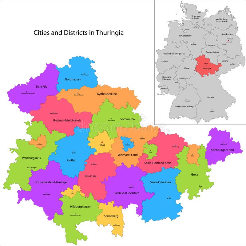
Free with trial State of Germany - Thuringia. Administrative division of Germany. Map of Thuringia with cities and districts. Mapping vectors State of Germany - Thuringia. Administrative division of Germany. Map of Thuringia with cities and districts
Free with trial Bahrain map. Administrative division of the Kingdom of Bahrain. Mapping vectors Bahrain map. Administrative division of the Kingdom of Bahrain
Free with trial Liberia map. Administrative division of the Republic of Liberia. Mapping vectors Liberia map. Administrative division of the Republic of Liberia
Free with trial Cornwall, United Kingdom, political map, with the county town Truro, and the Isles of Scilly. Ceremonial county in South West England, bordered by Devon, Atlantic Ocean, and English Channel. Vector. Mapping vectors Cornwall, with Isles of Scilly, UK, political map. Cornwall, United Kingdom, political map, with the county town Truro, and the Isles of Scilly. Ceremonial. Cornwall, United Kingdom, political map, with the county town Truro, and the Isles of Scilly. Ceremonial county in South West England, bordered by Devon, Atlantic Ocean, and English Channel. Vector
Free with trial Kyushu region of Japan, multi colored political map. Third-largest island of Japan, consisting of the seven prefectures Fukuoka, Kumamoto, Nagasaki, Oita, Saga, Kagoshima, Miyazaki, and Okinawa. Mapping vectors Kyushu region of Japan, multi colored political map. Third-largest island of Japan, consisting of the seven prefectures Fukuoka, Kumamoto, Nagasaki, Oita, Saga
Free with trial Gobi and Taklamakan Desert, political map. Gobi Desert, large, cold desert and grassland region in southern Mongolia and North China, and Taklamakan, in Xinjiang, northwest China. Illustration. Vector. Mapping vectors Gobi Desert and Taklamakan Desert, political map. Gobi and Taklamakan Desert, political map. Gobi Desert, large, cold desert and grassland region in southern. Gobi and Taklamakan Desert, political map. Gobi Desert, large, cold desert and grassland region in southern Mongolia and North China, and Taklamakan, in Xinjiang, northwest China. Illustration. Vector
Free with trial Botswana map. Administrative division of the Republic of Botswana. Mapping vectors Botswana map. Administrative division of the Republic of Botswana
Free with trial Phantom limb pain is shown with a human figure, brain diagram, and pain signals to illustrate brain remapping after limb loss. Outline diagram. Mapping vectors Phantom limb pain is shown with a human figure, brain ... Phantom limb pain is shown with a human figure, brain diagram, and pain signals to illustrate brain. Phantom limb pain is shown with a human figure, brain diagram, and pain signals to illustrate brain remapping after limb loss. Outline diagram
Free with trial Swaziland map. Administrative division of the Kingdom of Swaziland. Mapping vectors Swaziland map. Administrative division of the Kingdom of Swaziland
Free with trial Kyrgyzstan map. Administrative division of the Kyrgyz Republic. Mapping vectors Kyrgyzstan map. Administrative division of the Kyrgyz Republic
Free with trial East Timor map. Administrative division of the Democratic Republic of Timor-Leste. Mapping vectors East Timor map. Administrative division of the Democratic Republic of Timor-Leste
Free with trial Bangladesh map. Administrative division of the Peoples Republic of Bangladesh. Mapping vectors Bangladesh map. Administrative division of the Peoples Republic of Bangladesh
Free with trial Mauritania map. Administrative division of the Republic of the Islamic Republic of Mauritania. Mapping vectors Mauritania map. Administrative division of the Republic of the Islamic Republic of Mauritania
Free with trial Set of travel posters with Tokyo, detailed urban street plan city map, Silhouette city skyline, vector artwork. For design. Mapping vectors Set of travel posters with Tokyo, detailed urban street plan city map, Silhouette city skyline, vector artwork. For design
Free with trial Set of travel posters with Oslo, detailed urban street plan city map, Silhouette city skyline, vector artwork, set 2. For decorating walls. Mapping vectors Set of travel posters with Oslo, detailed urban street plan city map, Silhouette city skyline, vector artwork, set 2. For decorating walls
Free with trial Europe, Middle East, and North Africa, gray political map with international borders. Overview of continent Europe, geopolitical region Middle East, and the northern portion of the African continent. Mapping vectors Europe, Middle East, and North Africa, gray political map. With international borders. Overview of continent Europe, geopolitical region Middle East, and the. Europe, Middle East, and North Africa, gray political map with international borders. Overview of continent Europe, geopolitical region Middle East, and the northern portion of the African continent.
Free with trial Tree modern line with icons. Can use for brochure and business project background. Mapping vectors Tree modern line with icons. Can use for brochure and business project background
Free with trial Circle Rowel loop with icon. Can use for brochure and business project background. Mapping vectors Circle Rowel loop with icon. Can use for brochure and business project background
Free with trial Greeting card. Spring greeting card with flower ornament. Mapping vectors Greeting card. Spring greeting card with flower ornament
Free with trial GPS Navigator. Illustration on white background for design. Mapping vectors GPS navigator. Illustration on white background for design
Free with trial Problem solving technique aid chart, studying mind map with questions: What? , Why? , How? , Where? , Who? , When?. Lit light bulb thinking and searching ideas. Colorful round circle graphic on white background vector illustration. Mapping vectors Problem solving questions infographic modern vector. Problem solving technique aid chart, studying mind map with questions: What?, Why?, How?, Where?, Who?, When. Problem solving technique aid chart, studying mind map with questions: What?, Why?, How?, Where?, Who?, When?. Lit light bulb thinking and searching ideas. Colorful round circle graphic on white background vector illustration.
Free with trial Set of travel posters with Bangkok, detailed urban street plan city map, Silhouette city skyline, vector artwork. For decorating walls. Mapping vectors Set of travel posters with Bangkok, detailed urban street plan city map, Silhouette city skyline, vector artwork. For decorating walls
Free with trial Retro Color Political Map of USA, Canada, Mexico and central America. Vintage vector Map. Mapping vectors Retro Color Political Map of USA, Canada, Mexico and central America. Vintage vector Map
Free with trial Business diagram. Four blank numbered sequential steps business diagram. Mapping vectors Business diagram. Four blank numbered sequential steps business diagram
Free with trial Southern Europe, colored political map of Mediterranean Europe with the major countries Portugal, Spain, Italy, and Greece, as well as the Central Balkans, Andorra, Malta, San Marino and Vatican City. Mapping vectors Southern Europe, colored political map of Mediterranean Europe. With the major countries Portugal, Spain, Italy, and Greece, as well as the Central Balkans. Southern Europe, colored political map of Mediterranean Europe with the major countries Portugal, Spain, Italy, and Greece, as well as the Central Balkans, Andorra, Malta, San Marino and Vatican City.
Free with trial Set of travel posters with Budapest, detailed urban street plan city map, Silhouette city skyline, vector artwork, set 2. For decorating walls. Mapping vectors Set of travel posters with Budapest, detailed urban street plan city map, Silhouette city skyline, vector artwork, set 2. For decorating walls
Free with trial Cuba map. Administrative division of the Republic of Cuba. Mapping vectors Cuba map. Administrative division of the Republic of Cuba
Free with trial Mali map. Administrative division of the Republic of Mali. Mapping vectors Mali map. Administrative division of the Republic of Mali
Free with trial Syria map. Administrative division of the Syrian Arab Republic. Mapping vectors Syria map. Administrative division of the Syrian Arab Republic
Free with trial Gambia mp. Administrative division of the Republic of the Gambia. Mapping vectors Gambia mp. Administrative division of the Republic of the Gambia
Free with trial Niger map. Administrative division of the Republic of Niger. Mapping vectors Niger map. Administrative division of the Republic of Niger
Free with trial Nepal map. Administrative division of the Democratic Republic of Nepal. Mapping vectors Nepal map. Administrative division of the Democratic Republic of Nepal
Free with trial Bhutan map. Administrative division of the Kingdom of Bhutan. Mapping vectors Bhutan map. Administrative division of the Kingdom of Bhutan
Free with trial Guinea map. Administrative division of the Republic of Guinea. Mapping vectors Guinea map. Administrative division of the Republic of Guinea
Free with trial Brunei map. Administrative division of the Nation of Brunei. Mapping vectors Brunei map. Administrative division of the Nation of Brunei
Free with trial Jordan map. Administrative division of the Hashemite Kingdom of Jordan. Mapping vectors Jordan map. Administrative division of the Hashemite Kingdom of Jordan
Free with trial Lebanon map. Administrative division of the Lebanese Republic. Mapping vectors Lebanon map. Administrative division of the Lebanese Republic
Free with trial Lesotho map. Administrative division of the Kingdom of Lesotho. Mapping vectors Lesotho map. Administrative division of the Kingdom of Lesotho
Free with trial Senegal map. Administrative division of the Republic of Senegal. Mapping vectors Senegal map. Administrative division of the Republic of Senegal
Free with trial Djibouti map. Administrative division of the Republic of Djibouti. Mapping vectors Djibouti map. Administrative division of the Republic of Djibouti
Free with trial Seamless purple floral rose background. Illustration. Mapping vectors Seamless purple floral rose background. Illustration
 Sign in