Free with trial Man using virtual reality headset. Man wearing virtual reality glasses headset and connecting to the cyberspace, vr icons set. Mapping vectors Man using virtual reality headset. Man wearing virtual reality glasses headset and connecting to the cyberspace, vr icons set
Free with trial Set of travel posters with Washington, detailed urban street plan city map, Silhouette city skyline, vector artwork, collection of wall tourist decorations. Mapping vectors Set of travel posters with Washington, detailed urban street plan city map, Silhouette city skyline, vector artwork. Collection of wall tourist decorations
Free with trial Wyoming, WY, political map, with the capital Cheyenne. State in the Mountain West subregion of the Western United States of America, nicknamed Equality State, Cowboy State and Big Wyoming. Vector. Mapping vectors Wyoming, WY, political map, US state, nicknamed Equality State. Wyoming, WY, political map, with the capital Cheyenne. State in the Mountain West subregion of. Wyoming, WY, political map, with the capital Cheyenne. State in the Mountain West subregion of the Western United States of America, nicknamed Equality State, Cowboy State and Big Wyoming. Vector.
Free with trial Silicon Valley, a region of Northern California in the United States, political map. Global center for high technology and innovation, located in the southern part of the San Francisco Bay Area. Mapping vectors Silicon Valley, region of Northern California in USA, political map. Silicon Valley, a region of Northern California in the United States, political map. Global. Silicon Valley, a region of Northern California in the United States, political map. Global center for high technology and innovation, located in the southern part of the San Francisco Bay Area.
Free with trial Travel poster, urban street plan city map Naples and Palermo, vector illustration. For design map of roads, rivers and paths. Mapping vectors Travel poster, urban street plan city map Naples and Palermo, vector illustration. For design map of roads, rivers and paths
Free with trial North America Physical Map. Vintage color. No text. Vector illustration. Mapping vectors North America Physical Map. Vintage color. No text. Vector illustration
Free with trial Peoples Republic of China, PRC, gray political map. Area controlled by China in yellow color, and claimed but uncontrolled regions shown in brown. English labeling. Illustration over white. Vector. Mapping vectors Peoples Republic of China, PRC, gray political map. Area controlled by China in yellow color, and claimed but uncontrolled regions shown in brown. English
Free with trial Circle planing with icons. Can use for brochure and business project background. Mapping vectors Circle planing with icons. Can use for brochure and business project background
Free with trial Circle planing with icons. Can use for brochure and business project background. Mapping vectors Circle planing with icons. Can use for brochure and business project background
Free with trial African Great Lakes. Political map with capitals, borders, important cities, rivers and lakes. Lake Victoria, Tanganyika, Malawi, Turkana und the smaller ones. English labeling. Illustration. Vector. Mapping vectors African Great Lakes, political map. African Great Lakes. Political map with capitals, borders, important cities, rivers and lakes. Lake Victoria, Tanganyika. African Great Lakes. Political map with capitals, borders, important cities, rivers and lakes. Lake Victoria, Tanganyika, Malawi, Turkana und the smaller ones. English labeling. Illustration. Vector.
Free with trial Very simple modern stylish info graphic with a four step process flow, circling arrows, information boxes in a sophisticated gradient color scheme for visual flow presentation, ready for your custom text. Mapping vectors 4 Step Process Flow Corporate Info-graphic Vector. Very simple modern stylish info graphic with a four step process flow, circling arrows, information boxes in a. Very simple modern stylish info graphic with a four step process flow, circling arrows, information boxes in a sophisticated gradient color scheme for visual flow presentation, ready for your custom text.
Free with trial Paper mobile city navigation application software. Route internet gps, road and travel city. Vector illustration. Mapping vectors Paper mobile city navigation application software. Route internet gps, road and travel city. Vector illustration
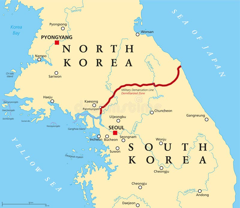
Free with trial Korean Peninsula, Demilitarized Zone, political map. North and South Korea with Military Demarcation Line, capitals, borders, most important cities and rivers. English labeling. Illustration. Vector. Mapping vectors Korean peninsula, demilitarized zone, political map. North and South Korea with Military Demarcation Line, capitals, borders, most important cities and rivers
Free with trial World map with pin. Earth map with location pointers in perspective. Travel technology 3d vector geolocation infographic app concept. Mapping vectors World map with pin. Earth map with location pointers in perspective. Travel 3d vector concept. World map with pin. Earth map with location pointers in. World map with pin. Earth map with location pointers in perspective. Travel technology 3d vector geolocation infographic app concept
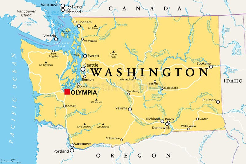
Free with trial Washington, WA, political map with the capital Olympia. State in the Pacific Northwest region of the Western United States of America. State of Washington, with nickname The Evergreen State. Vector. Mapping vectors Washington, WA, political map, US state, The Evergreen State. Washington, WA, political map with the capital Olympia. State in the Pacific Northwest region of. Washington, WA, political map with the capital Olympia. State in the Pacific Northwest region of the Western United States of America. State of Washington, with nickname The Evergreen State. Vector.
Free with trial China, political map with multicolored provinces. PRC, People`s Republic of China with capital Beijing, borders and administrative divisions. English labeling. Isolated illustration over white. Vector. Mapping vectors China, political map, multicolored provinces, administrative divisions. China, political map with multicolored provinces. PRC, People`s Republic of China with. China, political map with multicolored provinces. PRC, People`s Republic of China with capital Beijing, borders and administrative divisions. English labeling. Isolated illustration over white. Vector
Free with trial Pirate treasure map. Vector illustration. Mapping vectors Pirate treasure map. Vector illustration
Free with trial Set of travel posters with Atlanta, detailed urban street plan city map, Silhouette city skyline, vector artwork, collection of wall tourist decorations. Mapping vectors Set of travel posters with Atlanta, detailed urban street plan city map, Silhouette city skyline, vector artwork. Collection of wall tourist decorations
Free with trial USA Political Map isolated on white with water objects and cities. Mapping vectors USA Political Map isolated on white. With water objects and cities
Free with trial Counties of New England, outline map. Region in the Northeastern United States, consisting of the states Connecticut, Maine, Massachusetts, New Hampshire, Rhode Island, and Vermont. Isolated. Vector. Mapping vectors Counties of New England region of United States, outline map. Counties of New England, outline map. Region in the Northeastern United States, consisting of the. Counties of New England, outline map. Region in the Northeastern United States, consisting of the states Connecticut, Maine, Massachusetts, New Hampshire, Rhode Island, and Vermont. Isolated. Vector
Free with trial AI Drones for Security and Spectacle abstract concept vector illustration set. Drones patrol perimeters, perform light shows, and inspect underwater structures with smart control. abstract metaphor. Mapping vectors AI Drones for Security and Spectacle abstract concept vector illustrations. AI Drones for Security and Spectacle abstract concept vector illustration set. AI Drones for Security and Spectacle abstract concept vector illustration set. Drones patrol perimeters, perform light shows, and inspect underwater structures with smart control. abstract metaphor.
Free with trial Compass Mobile Application, UI, UX, KIT. Three screenshots of applications on smartphones. Navigation mobile App. Compass GUI. Futuristic style. Vector set. Mapping vectors Compass Mobile Application, UI, UX, KIT. Three screenshots of applications on smartphones. Navigation mobile App. Compass GUI. Futuristic style. Vector set
Free with trial Europe Road Map and Navigation Icons. Detailed illustration of Europe Map. Mapping vectors Europe Road Map and Navigation Icons. Detailed illustration of Europe Map
Free with trial Thin line flat design of rucksack packing and trip planning, preparing necessary items for adventure, hiking equipment backpacking. Modern vector illustration concept, isolated on white background. Mapping vectors Backpacking for trip line style illustration. Thin line flat design of rucksack packing and trip planning, preparing necessary items for adventure, hiking. Thin line flat design of rucksack packing and trip planning, preparing necessary items for adventure, hiking equipment backpacking. Modern vector illustration concept, isolated on white background.
Free with trial Greeting Card. Frame design for greeting card. Mapping vectors Greeting Card. Frame design for greeting card
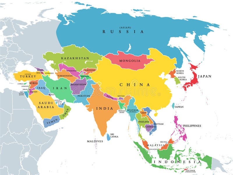
Free with trial Continent Asia, political map with colored single states and countries. With the Asian part of Russia and Turkey and Sinai Peninsula as African part. English labeling. Illustration over white. Vector. Mapping vectors Continent Asia, political map with colored single states and countries. With the Asian part of Russia and Turkey and Sinai Peninsula as African part. English
Free with trial Africa map vector illustration. Design. Mapping vectors Africa map vector illustration. Design
Free with trial Regions of the Global South, colored political map. Developing countries divided into the regions Africa, Asia, Latin America and the Caribbean, and Oceania. Countries of Global North in gray color. Mapping vectors Regions of the Global South, colored political map. Developing countries divided into the regions Africa, Asia, Latin America and the Caribbean, and Oceania
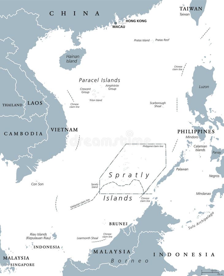
Free with trial South China Sea Islands, political map. Paracel and Spratly Islands, atolls, cays and reefs. Partially claimed by China and other neighboring states. Gray illustration on white background. Vector. Mapping vectors South China Sea Islands political map. South China Sea Islands, political map. Paracel and Spratly Islands, atolls, cays and reefs. Partially claimed by China. South China Sea Islands, political map. Paracel and Spratly Islands, atolls, cays and reefs. Partially claimed by China and other neighboring states. Gray illustration on white background. Vector.
Free with trial Travel poster, urban street plan city map Paris and Marseille, vector illustration. Detailed city plan for design detailed city plan for design. Mapping vectors Travel poster, urban street plan city map Paris and Marseille, vector illustration. Detailed city plan for design detailed city plan for design
Free with trial Micronesia, subregion of Oceania, political map. Composed of thousands of small islands in western Pacific Ocean next to Polynesia and Melanesia. English. Illustration on white background. Vector. Mapping vectors Micronesia, subregion of Oceania, political map. Composed of thousands of small islands in western Pacific Ocean next to Polynesia and Melanesia. English
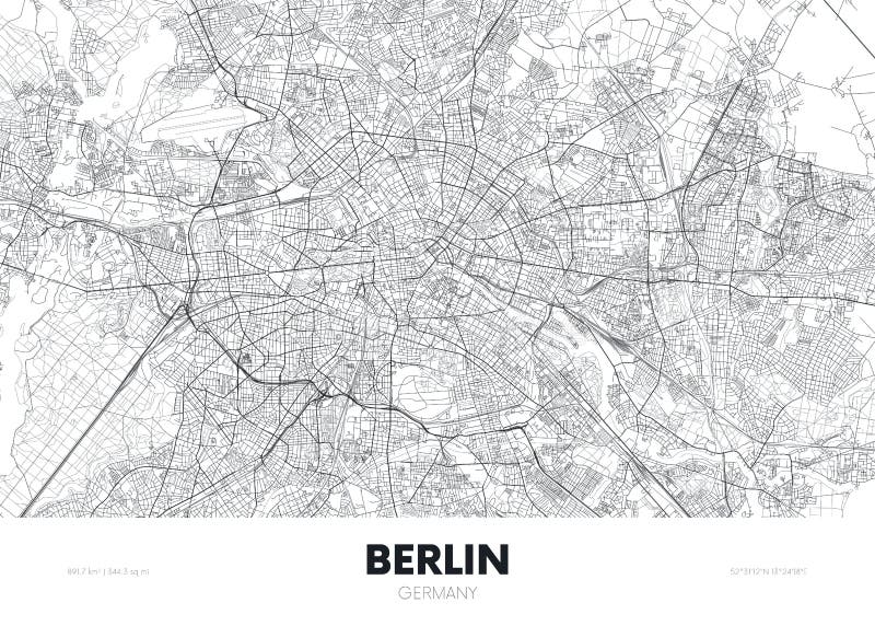
Free with trial City map Berlin Germany, travel poster detailed urban street plan, vector illustration. For design. Mapping vectors City map Berlin Germany, travel poster detailed urban street plan, vector illustration. For design
Free with trial Louisiana, LA, political map, with capital Baton Rouge and metropolitan area New Orleans. State in Deep South and South Central regions of the United States, nicknamed Pelican, Bayou and Creole State. Mapping vectors Louisiana, LA, political map, US state, nicknamed Pelican State. Louisiana, LA, political map, with capital Baton Rouge and metropolitan area New Orleans. State. Louisiana, LA, political map, with capital Baton Rouge and metropolitan area New Orleans. State in Deep South and South Central regions of the United States, nicknamed Pelican, Bayou and Creole State.
Free with trial World map dots. Vector representation of the World map made with round dots in four different colors. Editable eps file available. Mapping vectors World map dots. Vector representation of the World map made with round dots in four different colors. Editable eps file available
Free with trial Vector map kit. Vector isolated isometric map kit. Mapping vectors Vector map kit. Vector isolated isometric map kit
Free with trial Highway Road Building Construction Kit. Highway Road construction Kit to Build your own, see my portfolio for other kits. Mapping vectors Highway Road Building Construction Kit. Highway Road construction Kit to Build your own, see my portfolio for other kits
Free with trial North America Map and Navigation Icons. Vector illustration. Mapping vectors North America Map and Navigation Icons. Vector illustration
Free with trial West Africa region, political map. Area with borders. The westernmost countries on the African continent, also called Western Africa. Gray illustration on white background. Vector. Mapping vectors West Africa region political map. West Africa region, political map. Area with borders. The westernmost countries on the African continent, also called Western. West Africa region, political map. Area with borders. The westernmost countries on the African continent, also called Western Africa. Gray illustration on white background. Vector.
Free with trial San Juan Islands, part of Washington state, political map. Archipelago in the Pacific Northwest of the United States, east of Vancouver Island, in the Salish Sea, forming the core of San Juan County. Mapping vectors San Juan Islands, part of Washington state, political map. Archipelago in the Pacific Northwest of the United States, east of Vancouver Island, in the Salish
Free with trial Portugal Physical Map Isolated on White. Detailed vector illustration of map. Mapping vectors Portugal Physical Map Isolated on White. Detailed vector illustration of map
Free with trial Travel poster, urban street plan city map Hanoi and Ho Chi Minh, vector illustration. Detailed city plan for design. Mapping vectors Travel poster, urban street plan city map Hanoi and Ho Chi Minh, vector illustration. Detailed city plan for design
Free with trial Set of travel posters with Toronto, detailed urban street plan city map, Silhouette city skyline, vector artwork, collection of wall tourist decorations. Mapping vectors Set of travel posters with Toronto, detailed urban street plan city map, Silhouette city skyline, vector artwork. Collection of wall tourist decorations
Free with trial Principal tectonic plates of the Earth, world map. The sixteen major pieces of crust and uppermost mantle of the Earth, called the lithosphere, and consisting of oceanic and continental crust. Vector. Mapping vectors Principal tectonic plates of the Earth, world map. The sixteen major pieces of crust and uppermost mantle of the Earth, called the lithosphere, and consisting
Free with trial Vector Isometric smartphone with map navigation. Flat style. Mapping vectors Vector Isometric smartphone with map navigation. Flat style
Free with trial Nebraska, NE, political map with the capital Lincoln and the largest city Omaha. Triply landlocked State in the Midwestern subregion of the United States of America, nicknamed Cornhusker State. Vector. Mapping vectors Nebraska, NE, political map, US state, nicknamed Cornhusker State. Nebraska, NE, political map with the capital Lincoln and the largest city Omaha. Triply. Nebraska, NE, political map with the capital Lincoln and the largest city Omaha. Triply landlocked State in the Midwestern subregion of the United States of America, nicknamed Cornhusker State. Vector
Free with trial Maine, ME, political map with capital Augusta. Northernmost state in the United States of America, and located in the New England region. The Pine Tree State. Vacationland. Illustration. Vector. Mapping vectors Maine, ME, political map, The Pine Tree State, Vacationland. Maine, ME, political map with capital Augusta. Northernmost state in the United States of America. Maine, ME, political map with capital Augusta. Northernmost state in the United States of America, and located in the New England region. The Pine Tree State. Vacationland. Illustration. Vector.
Free with trial Blank mind map vertical seamless pattern. Vector blank mind map vertical seamless pattern background ornament with hand drawn elements. Mapping vectors Blank mind map vertical seamless pattern. Vector blank mind map vertical seamless pattern background ornament with hand drawn elements
Free with trial Detailed Europe Map and Colorful Map Markers. Detailed illustration of Europe Map. Mapping vectors Detailed Europe Map and Colorful Map Markers. Detailed illustration of Europe Map
Free with trial Creative doodle drawing art illustration. Mapping vectors Creative doodle drawing art illustration
Free with trial Regions of Florida, a state in the Southeastern United States, colored map. Frequently used division of the U. S. state into 9 main regions, and with boundaries of 67 counties. Isolated illustration. Mapping vectors Regions of Florida, state in Southeastern United States, colored map. Regions of Florida, a state in the Southeastern United States, colored map. Frequently used. Regions of Florida, a state in the Southeastern United States, colored map. Frequently used division of the U.S. state into 9 main regions, and with boundaries of 67 counties. Isolated illustration.
Free with trial Kansas, KS, political map with capital Topeka, important rivers and lakes. State in the Midwestern United States of America nicknamed The Sunflower State, also The Wheat or The Jayhawker State. Vector. Mapping vectors Kansas, KS, political map, US state, nicknamed The Sunflower State. Kansas, KS, political map with capital Topeka, important rivers and lakes. State in the. Kansas, KS, political map with capital Topeka, important rivers and lakes. State in the Midwestern United States of America nicknamed The Sunflower State, also The Wheat or The Jayhawker State. Vector
Free with trial Maryland, U. S. state, colored political map with county names and capital Annapolis. State in the New England region of Northeastern USA, subdivided into 23 counties and independent City of Baltimore. Mapping vectors Maryland, U.S. state, 23 counties and 1 independent city, multi colored map. Maryland, U.S. state, colored political map with county names and capital Annapolis. Maryland, U.S. state, colored political map with county names and capital Annapolis. State in the New England region of Northeastern USA, subdivided into 23 counties and independent City of Baltimore.
Free with trial Sphere on cycle vector template with icon. Can use for brochure and business project background. Mapping vectors Sphere on cycle vector template with icon. Can use for brochure and business project background
Free with trial Texas icon on green and black halftone ad. Green and black halftone banner template with a texas icon. Mapping vectors Texas icon on green and black halftone ad. Green and black halftone banner template with a texas icon
Free with trial Arrow origami business concept with icons. Can use for brochure and business project background. Mapping vectors Arrow origami business concept with icons. Can use for brochure and business project background
Free with trial South Dakota, SD, political map, with capital Pierre, and largest city Sioux Falls. State in the upper Midwestern subregion of the United States of America, nicknamed The Mount Rushmore State. Vector. Mapping vectors South Dakota, SD, political map, US state, The Mount Rushmore State. South Dakota, SD, political map, with capital Pierre, and largest city Sioux Falls. State in. South Dakota, SD, political map, with capital Pierre, and largest city Sioux Falls. State in the upper Midwestern subregion of the United States of America, nicknamed The Mount Rushmore State. Vector.
Free with trial Oceania, single states, political map. Geographic region, southeast of the Asia-Pacific region including Australasia, Melanesia, Micronesia and Polynesia. English. Illustration over white. Vector. Mapping vectors Oceania, single states, political map. Geographic region, southeast of the Asia-Pacific region including Australasia, Melanesia, Micronesia and Polynesia
Free with trial Connecticut, political map with capital Hartford. State of Connecticut, CT, southernmost state in New England region of northeastern United States of America. Gray illustration, over white. Vector. Mapping vectors Connecticut, gray political map, State of Connecticut, CT. Connecticut, political map with capital Hartford. State of Connecticut, CT, southernmost state in New. Connecticut, political map with capital Hartford. State of Connecticut, CT, southernmost state in New England region of northeastern United States of America. Gray illustration, over white. Vector.
Free with trial Africa, single countries, gray political map. Largest continent, including Madagascar. With English country names and international borders. Isolated illustration on white background. Vector. Mapping vectors Africa, single countries, gray political map. Largest continent, including Madagascar. With English country names and international borders. Isolated
Free with trial Blank mind map seamless pattern background. Vector blank mind map seamless pattern background with hand drawn elements. Mapping vectors Blank mind map seamless pattern background. Vector blank mind map seamless pattern background with hand drawn elements
Free with trial Concept of location / GPS based services on mobile devices. Current location symbol displayed on frameless touchscreen. Hand holding modern bezel-free smartphone. Mapping vectors Concept of location / GPS based services on mobile devices. Current location symbol displayed on frameless touchscreen. Hand holding modern bezel-free
Free with trial Set of travel posters with Vancouver, detailed urban street plan city map, Silhouette city skyline, vector artwork, set 2. For decorating walls. Mapping vectors Set of travel posters with Vancouver, detailed urban street plan city map, Silhouette city skyline, vector artwork, set 2. For decorating walls
Free with trial Westmoreland Map. Jamaica state. With cities and towns. Mapping vectors Westmoreland Map. Jamaica state. With cities and towns
Free with trial Travel poster, urban street plan city map Los Angeles and San Francisco, vector illustration. For design. Mapping vectors Travel poster, urban street plan city map Los Angeles and San Francisco, vector illustration. For design
Free with trial Colorado, CO political map with the capital Denver, most important rivers and lakes. State in the Mountain West subregion of the Western United States of America nicknamed The Centennial State. Vector. Mapping vectors Colorado, CO, political map, US state, nicknamed The Centennial State. Colorado, CO political map with the capital Denver, most important rivers and lakes. State. Colorado, CO political map with the capital Denver, most important rivers and lakes. State in the Mountain West subregion of the Western United States of America nicknamed The Centennial State. Vector
Free with trial United States of America, Census regions and divisions, colored political map. Map of the USA with four main regions, nine divisions, fifty states and the District of Columbia. Isolated illustration. Mapping vectors United States, Census regions and divisions, colored political map. United States of America, Census regions and divisions, colored political map. Map of the USA. United States of America, Census regions and divisions, colored political map. Map of the USA with four main regions, nine divisions, fifty states and the District of Columbia. Isolated illustration.
Free with trial Abstract geometric mesh of connected black dots and lines forming a complex network structure ideal for technology science backgrounds isolated on white background vector illustration. Mapping vectors Geometric Network Mesh with Connected Dots. Abstract geometric mesh of connected black dots and lines forming a complex network structure ideal for technology. Abstract geometric mesh of connected black dots and lines forming a complex network structure ideal for technology science backgrounds isolated on white background vector illustration
Free with trial Dna test infographic. Genome sequence map. Chromosome architecture, molecule sequencing chart. Genetic and technology concept. Barcoding template for design vector illustration background. Mapping vectors Dna test infographic. Genome sequence map. Chromosome architecture, molecule sequencing chart. Genetic concept. Dna test infographic. Genome sequence map. Dna test infographic. Genome sequence map. Chromosome architecture, molecule sequencing chart. Genetic and technology concept. Barcoding template for design vector illustration background
Free with trial Travel poster, urban street plan city map Belgrade and Bratislava, vector illustration. For design map of roads, rivers and paths. Mapping vectors Travel poster, urban street plan city map Belgrade and Bratislava, vector illustration. For design map of roads, rivers and paths
Free with trial Modern communication technology for business, computer interface elements, social networking connection. Unusual line icons set, flat design abstract pictogram vector illustration concept. Mapping vectors Communication technology pictogram icons set. Modern communication technology for business, computer interface elements, social networking connection. Unusual. Modern communication technology for business, computer interface elements, social networking connection. Unusual line icons set, flat design abstract pictogram vector illustration concept.
Free with trial Diagram template for business plan or system. Can use for brochure and business project background. Mapping vectors Diagram template for business plan or system. Can use for brochure and business project background
Free with trial North America Physical Map Isolated on White. Vector illustration. Mapping vectors North America Physical Map Isolated on White. Vector illustration
Free with trial Very simple modern stylish info graphic flow chart with simple four color flow and a more colorful gradient flow, and some cool bonus icons, for professional businesses and organizations. Mapping vectors Clean Corporate Infographic Flowchart Vector. Very simple modern stylish info graphic flow chart with simple four color flow and a more colorful gradient flow. Very simple modern stylish info graphic flow chart with simple four color flow and a more colorful gradient flow, and some cool bonus icons, for professional businesses and organizations.
Free with trial Black abstract geometric line drawing. A positive and negative version of a digital line drawing. Mapping vectors Black abstract geometric line drawing. A positive and negative version of a digital line drawing
Free with trial Pixel art style map of north america, contains. Relief continent and islands isolated on dark blue. Mapping vectors Pixel art style map of north america, contains. Relief continent and islands isolated on dark blue
Free with trial Lambert azimuthal equal-area world map projection. Black and white world map vector illustration. Mapping vectors Black and white lambert azimuthal projection. Lambert azimuthal equal-area world map projection. Black and white world map vector illustration. Lambert azimuthal equal-area world map projection. Black and white world map vector illustration.
Free with trial Idaho, U. S. state, subdivided into 44 counties, multi colored political map with capital Boise, borders and county names. State in the Mountain West region of the USA. Gem State, or also Potato State. Mapping vectors Idaho, U.S. state, subdivided into 44 counties, multi colored map. Idaho, U.S. state, subdivided into 44 counties, multi colored political map with capital Boise. Idaho, U.S. state, subdivided into 44 counties, multi colored political map with capital Boise, borders and county names. State in the Mountain West region of the USA. Gem State, or also Potato State.
Free with trial Pixel design world map. Vector illustration of the Pixel design world map. Mapping vectors Pixel design world map. Vector illustration of the Pixel design world map
Free with trial The United States of America, multi colored political map with the silhouettes of 50 states and postal abbreviations, and with the federal District of Columbia, as it is used for statistics. Vector. Mapping vectors The United States of America, multi colored political map. With the silhouettes of 50 states and postal abbreviations, and with the federal District of Columbia. The United States of America, multi colored political map with the silhouettes of 50 states and postal abbreviations, and with the federal District of Columbia, as it is used for statistics. Vector.
 Sign in