Free with trial USA Political Map and map pointers isolated on white with water objects and cities. Mapping vectors USA Political Map and map pointers isolated on white. With water objects and cities
Free with trial The Americas, political map with single states in different colors. Countries of the Caribbean, of North, Central and South America. Silhouettes. Isolated illustration on white background. Vector. Mapping vectors The Americas, political map with single states in different colors. Countries of the Caribbean, of North, Central and South America. Silhouettes. Isolated
Free with trial Pacific Ring of Fire,world map with oceanic trenches. The Rim of Fire,or also Circum-Pacific Belt. Region around the rim of the Pacific Ocean,where many volcanic eruptions and earthquakes occur. Mapping vectors Pacific Ring of Fire, Rim of Fire, world map with ocean trenches. Pacific Ring of Fire,world map with oceanic trenches. The Rim of Fire,or also Circum-Pacific. Pacific Ring of Fire,world map with oceanic trenches. The Rim of Fire,or also Circum-Pacific Belt. Region around the rim of the Pacific Ocean,where many volcanic eruptions and earthquakes occur.
Free with trial Travel poster, urban street plan city map Kuala Lumpur and Singapore, vector illustration. For design. Mapping vectors Travel poster, urban street plan city map Kuala Lumpur and Singapore, vector illustration. For design
Free with trial Smart Watch Navigator, Vector Flat design. Smart Watch Navigator. Vector Flat design. Mapping vectors Smart Watch Navigator, Vector Flat design. Smart Watch Navigator. Vector Flat design
Free with trial Northwest Passage, NWP, political map. Sea lane between Atlantic and Pacific Ocean through the Arctic Ocean, along the coast of North America via waterways through the Arctic Archipelago of Canada. Mapping vectors Northwest Passage, NWP, sea lane along North America, political map. Northwest Passage, NWP, political map. Sea lane between Atlantic and Pacific Ocean through. Northwest Passage, NWP, political map. Sea lane between Atlantic and Pacific Ocean through the Arctic Ocean, along the coast of North America via waterways through the Arctic Archipelago of Canada.
Free with trial Northern part of Mainland Southeast Asia, transport political map. Countries Thailand, Vietnam, Myanmar, Laos, and Cambodia, with the most important waterways on rivers, and with the largest cities. Mapping vectors Northern part of Mainland Southeast Asia, transport political map. Countries Thailand, Vietnam, Myanmar, Laos, and Cambodia, with the most important waterways
Free with trial Hurghada and vicinity, Egypt, political map. City and area in the Red Sea Governorate of Egypt, and one of the main tourist centres of the country, located on the Red Sea coast, with numerous resorts. Mapping vectors Hurghada, tourist centres on Red Sea coast in Egypt, political map. Hurghada and vicinity, Egypt, political map. City and area in the Red Sea Governorate of. Hurghada and vicinity, Egypt, political map. City and area in the Red Sea Governorate of Egypt, and one of the main tourist centres of the country, located on the Red Sea coast, with numerous resorts.
Free with trial English Channel political map. Also British Channel. Arm of Atlantic Ocean separates Southern England from northern France and link to North Sea by Strait of Dover. Busiest shipping area in the world. Mapping vectors English Channel, political map, busiest shipping area in the world. English Channel political map. Also British Channel. Arm of Atlantic Ocean separates Southern. English Channel political map. Also British Channel. Arm of Atlantic Ocean separates Southern England from northern France and link to North Sea by Strait of Dover. Busiest shipping area in the world.
Free with trial Abstract isometric low poly mesh platform with connected dots and lines ideal for technology, science, or data visualization concepts isolated on white background vector illustration. Mapping vectors Isometric Low Poly Network Mesh Platform Design. Abstract isometric low poly mesh platform with connected dots and lines ideal for technology, science, or data. Abstract isometric low poly mesh platform with connected dots and lines ideal for technology, science, or data visualization concepts isolated on white background vector illustration
Free with trial Stylized map of the Italian island of Sicily. Vector Illustration. Mapping vectors Stylized map of the Italian island of Sicily. Vector Illustration
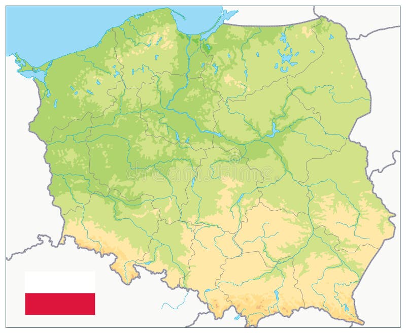
Free with trial Map of Poland. Isolated on white background. Mapping vectors Map of Poland. Isolated on white background
Free with trial Rhode Island, political map with the capital Providence. State of Rhode Island and Providence Plantations, RI, a state in the New England region of the United States of America. Illustration. Vector. Mapping vectors Rhode Island, RI, political map, State of Rhode Island and Providence Plantations. Rhode Island, political map with the capital Providence. State of Rhode Island. Rhode Island, political map with the capital Providence. State of Rhode Island and Providence Plantations, RI, a state in the New England region of the United States of America. Illustration. Vector.
Free with trial The world with most important circles of latitudes and longitudes, gray political map. Equator, Greenwich meridian, Arctic and Antarctic Circle, Tropic of Cancer and Capricorn. Illustration. Vector. Mapping vectors World most important circles of latitudes and longitudes, gray map. The world with most important circles of latitudes and longitudes, gray political map. The world with most important circles of latitudes and longitudes, gray political map. Equator, Greenwich meridian, Arctic and Antarctic Circle, Tropic of Cancer and Capricorn. Illustration. Vector.
Free with trial Diagram template with icon. Can use for brochure and business project background. Mapping vectors Diagram template with icon. Can use for brochure and business project background
Free with trial Seamless floral background. The seamless floral pink background wallpaper illustration. Mapping vectors Seamless floral background. The seamless floral pink background wallpaper illustration
Free with trial Peoples Republic of China, PRC, political map. Area controlled by China in yellow, and claimed but uncontrolled regions shown in orange. Capitals and borders. English labeling. Illustration. Vector. Mapping vectors China, controlled and claimed regions, political map. Peoples Republic of China, PRC, political map. Area controlled by China in yellow, and claimed but. Peoples Republic of China, PRC, political map. Area controlled by China in yellow, and claimed but uncontrolled regions shown in orange. Capitals and borders. English labeling. Illustration. Vector.
Free with trial North America Map. Isolated monochrome shape. Vector illustration. Mapping vectors North America Map. Isolated monochrome shape. Vector. North America Map. Isolated monochrome shape. Vector illustration. North America Map. Isolated monochrome shape. Vector illustration.
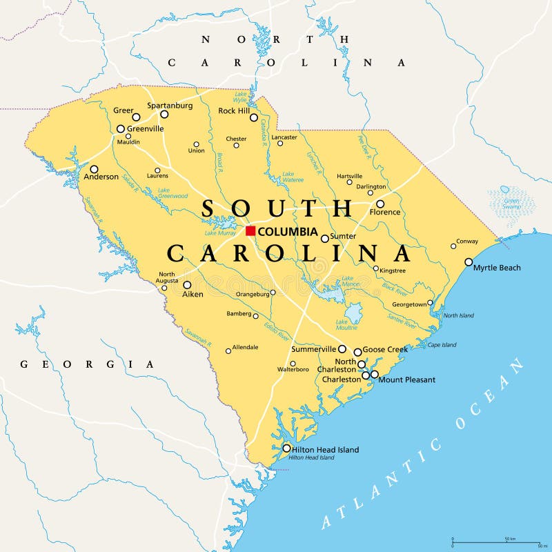
Free with trial South Carolina, SC, political map, with the capital Columbia, largest cities and borders. State in the southeastern region of the United States of America. The Palmetto State. Illustration. Vector. Mapping vectors South Carolina, SC, political map, The Palmetto State. South Carolina, SC, political map, with the capital Columbia, largest cities and borders. State in the. South Carolina, SC, political map, with the capital Columbia, largest cities and borders. State in the southeastern region of the United States of America. The Palmetto State. Illustration. Vector.
Free with trial Map of countries officially not using metric units. Liberia, Myanmar and the United States of America using the Imperial system. Infographics. Isolated illustration on white background. Vector. Mapping vectors Map of countries officially not using metric units. Liberia, Myanmar and the United States of America using the Imperial system. Infographics. Isolated
Free with trial Maryland, MD, gray political map. State in Mid-Atlantic region of United States of America. Capital Annapolis. Old Line State. Free State. Little America. America in Miniature. Illustration. Vector. Mapping vectors Maryland, MD, gray political map, Old Line State, Free State. Maryland, MD, gray political map. State in Mid-Atlantic region of United States of America. Capital. Maryland, MD, gray political map. State in Mid-Atlantic region of United States of America. Capital Annapolis. Old Line State. Free State. Little America. America in Miniature. Illustration. Vector.
Free with trial Penang, a state of Malaysia in Southeast Asia, gray political map. Located on the coast of Peninsular Malaysia along Strait of Malacca in the Andaman Sea, with capital George Town on Penang Island. Mapping vectors Penang, a state of Malaysia in Southeast Asia, gray political map. Located on the coast of Peninsular Malaysia along Strait of Malacca in the Andaman Sea, with
Free with trial Minnesota, MN, political map, with capital Saint Paul and metropolitan area Minneapolis. State in the upper Midwestern United States. Nicknamed Land of 10,000 Lakes, North Star State and Gopher State. Mapping vectors Minnesota, MN, political map, US state, nicknamed Land of 10,000 Lakes. Minnesota, MN, political map, with capital Saint Paul and metropolitan area Minneapolis. Minnesota, MN, political map, with capital Saint Paul and metropolitan area Minneapolis. State in the upper Midwestern United States. Nicknamed Land of 10,000 Lakes, North Star State and Gopher State.
Free with trial Azores, Madeira, and Canary Islands, political map. Autonomous regions of Portugal and Spain, archipelagos of volcanic islands, in the Macaronesia region of North Atlantic ocean, next to North Africa. Mapping vectors Azores, Madeira, and Canary Islands, autonomous regions, political map. Azores, Madeira, and Canary Islands, political map. Autonomous regions of Portugal and. Azores, Madeira, and Canary Islands, political map. Autonomous regions of Portugal and Spain, archipelagos of volcanic islands, in the Macaronesia region of North Atlantic ocean, next to North Africa.
Free with trial Poland Physical Map. No text. Highly detailed map vector illustration. Image contains layers with shaded contours, water objects. Mapping vectors Poland Physical Map. No text. Highly detailed map vector illustration. Image contains layers with shaded contours, water objects
Free with trial Alternative version of tree, bushes, and small vegetation inspired from Japanese garden in spring, made on oblique projection. Images are designed to align into square grid for easy game tile-mapping. Mapping vectors Spring Plants Set Japanese Garden Alternative Version. Alternative version of tree, bushes, and small vegetation inspired from Japanese garden in spring, made on. Alternative version of tree, bushes, and small vegetation inspired from Japanese garden in spring, made on oblique projection. Images are designed to align into square grid for easy game tile-mapping.
Free with trial Cook Islands, gray political map with capital Avarua. Self-governing island country in South Pacific Ocean in free association with New Zealand, comprising 15 islands. English. Illustration. Vector. Mapping vectors Cook Islands gray political map with capital Avarua. Cook Islands, gray political map with capital Avarua. Self-governing island country in South Pacific Ocean. Cook Islands, gray political map with capital Avarua. Self-governing island country in South Pacific Ocean in free association with New Zealand, comprising 15 islands. English. Illustration. Vector.
Free with trial City map Minsk, monochrome detailed plan, vector illustration. Roads, trails and rivers. Mapping vectors City map Minsk, monochrome detailed plan, vector illustration. Roads, trails and rivers
Free with trial Map pins, pointers flat icons. Sign for location map, web button or marker for navigation gps, vector illustration. Mapping vectors Map pins, pointers flat icons. Sign for location map, web button or marker for navigation gps, vector illustration
Free with trial Business man vector template. Can use for brochure and business project background. Mapping vectors Business man vector template. Can use for brochure and business project background
Free with trial Leaf number business concept. Can use for brochure and business project background. Mapping vectors Leaf number business concept. Can use for brochure and business project background
Free with trial Medical Healthcare Icons with People Charting Disease. Or Scientific Discovery. Mapping vectors Medical Healthcare Icons with People Charting Disease. Or Scientific Discovery
Free with trial Texas icon on orange wave background. Orange wave backdrop with a texas state icon. Mapping vectors Texas icon on orange wave background. Orange wave backdrop with a texas state icon
Free with trial Pennsylvania, U. S. state, political map. Commonwealth of Pennsylvania, a state in the Northeastern United States of America with capital Harrisburg. Keystone State. Quaker State. Illustration. Vector. Mapping vectors Pennsylvania, U.S. state, political map. Commonwealth of Pennsylvania, a state in the Northeastern United States of America with capital Harrisburg. Keystone
Free with trial Missouri, MO, political map, with capital Jefferson City, and largest cities, lakes and rivers. State in Midwestern region of United States, nicknamed Show Me State, Cave State and Mother of the West. Mapping vectors Missouri, MO, political map, US state, nicknamed Show Me State. Missouri, MO, political map, with capital Jefferson City, and largest cities, lakes and rivers. Missouri, MO, political map, with capital Jefferson City, and largest cities, lakes and rivers. State in Midwestern region of United States, nicknamed Show Me State, Cave State and Mother of the West.
Free with trial Sao Miguel Island, Azores, Portugal, gray political map with capital Ponta Delgada. Nicknamed The Green Island, the largest and most populous island in the Portuguese archipelago of the Azores. Vector. Mapping vectors Sao Miguel Island, Azores, Portugal, gray political map. With capital Ponta Delgada. Nicknamed The Green Island, the largest and most populous island in the. Sao Miguel Island, Azores, Portugal, gray political map with capital Ponta Delgada. Nicknamed The Green Island, the largest and most populous island in the Portuguese archipelago of the Azores. Vector
Free with trial Iowa, IA, political map, with the capital Des Moines and most important cities, rivers and lakes. State in the Midwestern region of the United States of America, nicknamed The Hawkeye State. Vector. Mapping vectors Iowa, IA, political map, US state, nicknamed The Hawkeye State. Iowa, IA, political map, with the capital Des Moines and most important cities, rivers and lakes. Iowa, IA, political map, with the capital Des Moines and most important cities, rivers and lakes. State in the Midwestern region of the United States of America, nicknamed The Hawkeye State. Vector.
Free with trial United States of America, multi colored political map. 50 states with own geographic territory, constituent entities, bound together in a union and a federal government. English. Illustration. Vector. Mapping vectors United States of America, multi colored political map. 50 states with own geographic territory, constituent entities, bound together in a union and a federal
Free with trial Taiwan Area, political map with capital Taipei. Free Area of the Republic of China ROC. Provinces and islands groups of Taiwan, located between the East and the South China Sea. Illustration. Vector. Mapping vectors Taiwan Area, political map, Free Area of the Republic of China. Taiwan Area, political map with capital Taipei. Free Area of the Republic of China ROC. Provinces. Taiwan Area, political map with capital Taipei. Free Area of the Republic of China ROC. Provinces and islands groups of Taiwan, located between the East and the South China Sea. Illustration. Vector
Free with trial The World, important circles of latitudes and longitudes, blue colored political map. Equator, Greenwich meridian, Arctic and Antarctic Circle, Tropic of Cancer and Capricorn. Illustration. Vector. Mapping vectors The World, important circles of latitudes and longitudes, political map. The World, important circles of latitudes and longitudes, blue colored political map. The World, important circles of latitudes and longitudes, blue colored political map. Equator, Greenwich meridian, Arctic and Antarctic Circle, Tropic of Cancer and Capricorn. Illustration. Vector.
Free with trial Sketch draw smartphone with navigation map and find government building vector illustration. Mapping vectors Sketch draw smartphone with map. Sketch draw smartphone with navigation map and find government building vector illustration. Sketch draw smartphone with navigation map and find government building vector illustration.
Free with trial Set of travel posters with Hong Kong, detailed urban street plan city map, Silhouette city skyline, vector artwork, collection of wall tourist decorations. Mapping vectors Set of travel posters with Hong Kong, detailed urban street plan city map, Silhouette city skyline, vector artwork. Collection of wall tourist decorations
Free with trial Travel poster, urban street plan city map New York and Washington, vector illustration. For design. Mapping vectors Travel poster, urban street plan city map New York and Washington, vector illustration. For design
Free with trial Data system diagram vector template with icon. Can use for brochure and business project background. Mapping vectors Data system diagram vector template with icon. Can use for brochure and business project background
Free with trial New Hampshire, NH, gray political map, with capital Concord. State in the New England region of United States of America. The Granite State. The White Mountain State. Illustration over white. Vector. Mapping vectors New Hampshire, NH, gray political map, The Granite State. New Hampshire, NH, gray political map, with capital Concord. State in the New England region of United. New Hampshire, NH, gray political map, with capital Concord. State in the New England region of United States of America. The Granite State. The White Mountain State. Illustration over white. Vector.
Free with trial Pin icon route. Route location icon, two pin sign and dotted line path, start and end journey concept, one color vector illustration isolated on white background. Mapping vectors Pin icon route. Route location icon, two pin sign and dotted line path, start and end journey concept, one color vector illustration isolated on white background
Free with trial Okinawa Islands, political map. Island group in the Okinawa Prefecture of Japan, in the East China Sea, with the capital Naha. Part of the larger Ryukyu Islands. English labeling. Illustration. Vector. Mapping vectors Okinawa Islands, in the Okinawa Prefecture, Japan, political map. Okinawa Islands, political map. Island group in the Okinawa Prefecture of Japan, in the East. Okinawa Islands, political map. Island group in the Okinawa Prefecture of Japan, in the East China Sea, with the capital Naha. Part of the larger Ryukyu Islands. English labeling. Illustration. Vector
Free with trial Crimea gray political map. Peninsula in Eastern Europe on northern coast of the Black Sea with disputed status. Controlled and governed by Russia, internationally recognized as part of Ukraine. Vector. Mapping vectors Crimea, peninsula in Eastern Europe, gray political map. Crimea gray political map. Peninsula in Eastern Europe on northern coast of the Black Sea with disputed. Crimea gray political map. Peninsula in Eastern Europe on northern coast of the Black Sea with disputed status. Controlled and governed by Russia, internationally recognized as part of Ukraine. Vector
Free with trial Flat GPS navigation in the phone with a red and blue pointers. GPS tracking map. Track navigation pins on street maps, navigate mapping technology and locate position pin. Mapping vectors Flat GPS navigation in the phone with a red and blue pointers. GPS tracking map. Track navigation pins on street maps. Navigate mapping technology and locate
Free with trial Kanto region of Japan, political map. Geographical region of the island Honshu, including the Greater Tokyo Area, encompassing prefectures Gunma, Tochigi, Ibaraki, Saitama, Tokyo, Chiba and Kanagawa. Mapping vectors Kanto region of Japan, political map. Geographical region of the island Honshu, including the Greater Tokyo Area, encompassing prefectures Gunma, Tochigi
Free with trial Old retro color map of Germany. Vector illustration. Mapping vectors Old retro color map of Germany. Vector illustration
Free with trial The sinusoidal pseudocylindrical equal-area world map projection. Black and white world map vector illustration. Mapping vectors Black and white Sinusoidal projection. The sinusoidal pseudocylindrical equal-area world map projection. Black and white world map vector illustration. The sinusoidal pseudocylindrical equal-area world map projection. Black and white world map vector illustration.
Free with trial South America, multi colored political map with international borders and capitals. Continent, bordered by the Pacific and Atlantic Ocean, North America and the Caribbean Sea. Isolated illustration. Mapping vectors South America, multi colored political map with borders and capitals. South America, multi colored political map with international borders and capitals. South America, multi colored political map with international borders and capitals. Continent, bordered by the Pacific and Atlantic Ocean, North America and the Caribbean Sea. Isolated illustration.
Free with trial Mascarene Islands, political map. Mauritius, Reunion and Rodrigues. Mascarenhas Archipelago, a group of islands in the Indian Ocean. English labeling. Gray illustration on white background. Vector. Mapping vectors Mascarene Islands, gray map, Mauritius, Reunion, Rodrigues. Mascarene Islands, political map. Mauritius, Reunion and Rodrigues. Mascarenhas Archipelago, a group. Mascarene Islands, political map. Mauritius, Reunion and Rodrigues. Mascarenhas Archipelago, a group of islands in the Indian Ocean. English labeling. Gray illustration on white background. Vector.
Free with trial South Carolina, SC, gray political map, with capital Columbia, largest cities and borders. State in the southeastern region of the United States of America. The Palmetto State. Illustration. Vector. Mapping vectors South Carolina, SC, gray political map, The Palmetto State. South Carolina, SC, gray political map, with capital Columbia, largest cities and borders. State in. South Carolina, SC, gray political map, with capital Columbia, largest cities and borders. State in the southeastern region of the United States of America. The Palmetto State. Illustration. Vector.
Free with trial Square cork board with isolated notes and photographs. Vector wood panel with papers and rope connections. Ideas and relationships visualization. Plank with pinned elements and attached sheets. Mapping vectors Cork board with papers, photos and rope connection. Square cork board with isolated notes and photographs. Vector wood panel with papers and rope connections. Square cork board with isolated notes and photographs. Vector wood panel with papers and rope connections. Ideas and relationships visualization. Plank with pinned elements and attached sheets
Free with trial East Africa region, political map. Area with borders. Easterly region of the African continent, also called Eastern Africa. Gray illustration on white background. Vector. Mapping vectors East Africa region political map. East Africa region, political map. Area with borders. Easterly region of the African continent, also called Eastern Africa. East Africa region, political map. Area with borders. Easterly region of the African continent, also called Eastern Africa. Gray illustration on white background. Vector.
Free with trial Doctor with fruit. Illustration of medical doctor with fruit. Mapping vectors Doctor with fruit. Illustration of medical doctor with fruit
Free with trial Kanto Region of Japan, colored political map. Geographical region of island Honshu, including Greater Tokyo Area, encompassing prefectures Gunma, Tochigi, Ibaraki, Saitama, Tokyo, Chiba and Kanagawa. Mapping vectors Kanto Region of Japan, colored political map. Geographical region of island Honshu, including Greater Tokyo Area, encompassing prefectures Gunma, Tochigi
Free with trial Arkansas, AR, political map, with capital Little Rock, and largest cities, lakes and rivers. Landlocked state in the South Central United States, nicknamed The Natural State, and Land of Opportunity. Mapping vectors Arkansas, AR, political map, US state, nicknamed The Natural State. Arkansas, AR, political map, with capital Little Rock, and largest cities, lakes and rivers. Arkansas, AR, political map, with capital Little Rock, and largest cities, lakes and rivers. Landlocked state in the South Central United States, nicknamed The Natural State, and Land of Opportunity.
Free with trial Windward Islands, gray political map. Islands of Lesser Antilles, south of Leeward Islands in the Caribbean Sea. From Dominica, Martinique, Saint Lucia, Saint Vincent and the Grenadines, to Grenada. Mapping vectors Windward Islands, gray political map, islands in the Caribbean Sea. Windward Islands, gray political map. Islands of Lesser Antilles, south of Leeward Islands in. Windward Islands, gray political map. Islands of Lesser Antilles, south of Leeward Islands in the Caribbean Sea. From Dominica, Martinique, Saint Lucia, Saint Vincent and the Grenadines, to Grenada.
Free with trial Austria Map and World Map isolated on transparent background. Highly detailed vector illustration of map. Mapping vectors Austria Map and World Map isolated on transparent background. Highly detailed vector illustration of map
Free with trial Hurricane free Caribbean islands, political map. The Leeward Antilles and Windward Islands are safest from Hurricanes. Aruba, Barbados, Bonaire, Curacao, Grenada, The Grenadines, Trinidad and Tobago. Mapping vectors Hurricane free Caribbean islands, map of Leeward Antilles and Windward Islands. Hurricane free Caribbean islands, political map. The Leeward Antilles and. Hurricane free Caribbean islands, political map. The Leeward Antilles and Windward Islands are safest from Hurricanes. Aruba, Barbados, Bonaire, Curacao, Grenada, The Grenadines, Trinidad and Tobago.
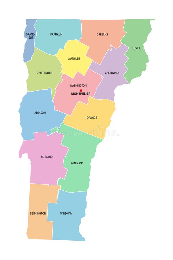
Free with trial Vermont, U. S. state, subdivided into 14 counties, political map with borders and county names. State in the New England region of the Northeastern United States, nicknamed The Green Mountain State. Mapping vectors Vermont, U.S. state, subdivided into 14 counties, political map. With borders and county names. State in the New England region of the Northeastern United. Vermont, U.S. state, subdivided into 14 counties, political map with borders and county names. State in the New England region of the Northeastern United States, nicknamed The Green Mountain State.
Free with trial Czech Republic Administrative Map. No text - Detailed map of Czech Republic vector illustration - All elements are separated in editable layers clearly labeled. Mapping vectors Czech Republic Administrative Map. No text. Detailed map of Czech Republic vector illustration - All elements are separated in editable layers clearly labeled
Free with trial New Hampshire, U. S. state, subdivided into 10 counties, multi colored political map with capital Concord, borders and county names. State in the New England region of Northeastern USA. Granite State. Mapping vectors New Hampshire, U.S. state, subdivided into 10 counties, colored map. New Hampshire, U.S. state, subdivided into 10 counties, multi colored political map with. New Hampshire, U.S. state, subdivided into 10 counties, multi colored political map with capital Concord, borders and county names. State in the New England region of Northeastern USA. Granite State.
Free with trial Vermont, U. S. state, subdivided into 14 counties, multi colored political map with capital Montpelier, borders and county names. State in the New England region of United States. Green Mountain State. Mapping vectors Vermont, U.S. state, subdivided into 14 counties, multi colored map. Vermont, U.S. state, subdivided into 14 counties, multi colored political map with capital. Vermont, U.S. state, subdivided into 14 counties, multi colored political map with capital Montpelier, borders and county names. State in the New England region of United States. Green Mountain State.
Free with trial White paper topography relief. Abstract paper cut background. Realistic papercut decoration textured with wavy layers. Carving art. Vector 3d illustration. Material design concept. Template for design. Mapping vectors White paper topography relief. Abstract paper cut background. Realistic papercut decoration textured with wavy layers. Carving art. Vector 3d illustration
Free with trial Channel Islands political map. Crown dependencies Bailiwick of Guernsey and Bailiwick of Jersey with capitals. Archipelago off the french coast of Normandy. English labeling. Illustration. Vector. Mapping vectors Channel Islands Guernsey and Jersey, political map. Channel Islands political map. Crown dependencies Bailiwick of Guernsey and Bailiwick of Jersey with capitals. Channel Islands political map. Crown dependencies Bailiwick of Guernsey and Bailiwick of Jersey with capitals. Archipelago off the french coast of Normandy. English labeling. Illustration. Vector.
Free with trial State of Wisconsin subdivided into 72 counties, outline map. A state in the Great Lakes region of the Upper Midwest of the United States, nicknamed Badger State. Map with boundaries and county names. Mapping vectors State of Wisconsin subdivided into 72 counties, outline map. A state in the Great Lakes region of the Upper Midwest of the United States, nicknamed Badger
Free with trial Bering Strait, political map. Strait between the North Pacific Ocean and the Arctic Ocean, separating the Chukchi Peninsula of the Russian Far East from the Seward Peninsula of Alaska, United States. Mapping vectors Bering Strait, political map, strait between Russia and United States. Bering Strait, political map. Strait between the North Pacific Ocean and the Arctic Ocean. Bering Strait, political map. Strait between the North Pacific Ocean and the Arctic Ocean, separating the Chukchi Peninsula of the Russian Far East from the Seward Peninsula of Alaska, United States.
Free with trial Portugal Physical Map Retro Colors - Detailed map of Portugal vector illustration - All elements are separated in editable layers clearly labeled. Mapping vectors Portugal Physical Map Retro Colors. Detailed map of Portugal vector illustration - All elements are separated in editable layers clearly labeled
Free with trial Pirate treasure map. Vector illustration. Mapping vectors Pirate treasure map. Vector illustration
Free with trial The Bosporus or Bosphorus, political map. The Strait of Istanbul, a narrow, natural strait and international waterway in Turkey. It connects the Black Sea with the Sea of Marmara. Illustration. Vector. Mapping vectors The Bosporus or Bosphorus, Strait of Istanbul, political map. The Bosporus or Bosphorus, political map. The Strait of Istanbul, a narrow, natural strait and. The Bosporus or Bosphorus, political map. The Strait of Istanbul, a narrow, natural strait and international waterway in Turkey. It connects the Black Sea with the Sea of Marmara. Illustration. Vector
Free with trial Spain and Italy Map. Vector illustration. Mapping vectors Spain and Italy Map. Vector illustration
Free with trial Dragon illustartion. Hand drawn cartoon of dragon. Mapping vectors Dragon illustartion. Hand drawn cartoon of dragon
Free with trial Kansai region, or also Kinki region in Japan, multi colored political map. Southern-central region of main island Honshu, consisting of prefectures Hyogo, Mie, Nara, Osaka, Kyoto, Shiga, and Wakayama. Mapping vectors Kansai region, or Kinki region in Japan, colored political map. Kansai region, or also Kinki region in Japan, multi colored political map. Southern-central. Kansai region, or also Kinki region in Japan, multi colored political map. Southern-central region of main island Honshu, consisting of prefectures Hyogo, Mie, Nara, Osaka, Kyoto, Shiga, and Wakayama.
Free with trial Eastern Caribbean islands, gray political map. Puerto Rico, Virgin Islands, Leeward and Windward Islands, and part of the Leeward Antilles north the coast of Venezuela, located in the Caribbean Sea. Mapping vectors Eastern Caribbean islands, Leeward and Windward Islands, gray political map. Eastern Caribbean islands, gray political map. Puerto Rico, Virgin Islands, Leeward. Eastern Caribbean islands, gray political map. Puerto Rico, Virgin Islands, Leeward and Windward Islands, and part of the Leeward Antilles north the coast of Venezuela, located in the Caribbean Sea.
Free with trial Nuclear-weapon states, political map. Eight sovereign states that have successfully detonated nuclear weapons, shown in blue color. English labeling. Illustration on white background. Vector. Mapping vectors Nuclear-weapon states, political map. Eight sovereign states that have successfully detonated nuclear weapons, shown in blue color. English labeling
Free with trial Infographics Transport for Rail Road and Water EPS10. All objects grouped separately and easy to edit, EPS10. Mapping vectors Infographics Transport for Rail Road and Water EPS10. All objects grouped separately and easy to edit, EPS10
 Sign in