Free with trial An image of a map pin web button. Mapping vectors Map Pin Web Button. An image of a map pin web button. An image of a map pin web button.
Free with trial Flat line design of web banner template with outline icons of mobile navigation GPS system, tracking map location and find the right way. Modern vector illustration concept for website or infographics. Mapping vectors Mobile navigation flat line banner. Flat line design of web banner template with outline icons of mobile navigation GPS system, tracking map location and find. Flat line design of web banner template with outline icons of mobile navigation GPS system, tracking map location and find the right way. Modern vector illustration concept for website or infographics.
Free with trial Travel poster, urban street plan city map London and Birmingham, vector illustration. For design map of roads, rivers and paths. Mapping vectors Travel poster, urban street plan city map London and Birmingham, vector illustration. For design map of roads, rivers and paths
Free with trial State of Germany - Saxony-Anhalt. Administrative division of Germany. Map of Saxony-Anhalt with cities and districts. Mapping vectors State of Germany - Saxony-Anhalt. Administrative division of Germany. Map of Saxony-Anhalt with cities and districts
Free with trial Face-emotion-icon. Vector paper set face emotion. Mapping vectors Face-emotion-icon. Vector paper set face emotion
Free with trial Southwest Asia, political map with borders. Also called Western, West or Southwestern Asia. Subregion, overlapping with Middle East, including Caucasus. Gray illustration on white background. Vector. Mapping vectors Southwest Asia gray political map. Southwest Asia, political map with borders. Also called Western, West or Southwestern Asia. Subregion, overlapping with Middle. Southwest Asia, political map with borders. Also called Western, West or Southwestern Asia. Subregion, overlapping with Middle East, including Caucasus. Gray illustration on white background. Vector.
Free with trial Travel poster, urban street plan city map Gothenburg and Glasgow, vector illustration. For decorating walls. Mapping vectors Travel poster, urban street plan city map Gothenburg and Glasgow, vector illustration. For decorating walls
Free with trial Travel poster, urban street plan city map Oslo and Copenhagen, vector illustration. For design. Mapping vectors Travel poster, urban street plan city map Oslo and Copenhagen, vector illustration. For design
Free with trial Patmos, Greek island, gray political map. Island of Greece in the Aegean Sea, northernmost part of Dodecanese. Here John of Patmos received the visions found in Book of Revelation of New Testament. Mapping vectors Patmos, Greek island in the Aeagean Sea, gray political map. Patmos, Greek island, gray political map. Island of Greece in the Aegean Sea, northernmost part of. Patmos, Greek island, gray political map. Island of Greece in the Aegean Sea, northernmost part of Dodecanese. Here John of Patmos received the visions found in Book of Revelation of New Testament.
Free with trial Gran Canaria gray political map with capital Las Palmas and important towns. Grand Canary Island, part of Spain, second most populous Island of Canary Islands, off the Atlantic coast of Africa. Vector. Mapping vectors Gran Canaria, Grand Canary Island, gray political map. Gran Canaria gray political map with capital Las Palmas and important towns. Grand Canary Island, part of. Gran Canaria gray political map with capital Las Palmas and important towns. Grand Canary Island, part of Spain, second most populous Island of Canary Islands, off the Atlantic coast of Africa. Vector
Free with trial China Physical Map. on white. No text. High detailed China Relief map. Mapping vectors China Physical Map. on white. No text. High detailed China Relief map
Free with trial Idaho, ID, political map with the capital Boise, borders, important cities, rivers and lakes. State in the Pacific Northwest region of the Western United States of America, nicknamed Gem State. Vector. Mapping vectors Idaho, ID, political map, US state, Gem State. Idaho, ID, political map with the capital Boise, borders, important cities, rivers and lakes. State in the Pacific. Idaho, ID, political map with the capital Boise, borders, important cities, rivers and lakes. State in the Pacific Northwest region of the Western United States of America, nicknamed Gem State. Vector
Free with trial Set of web icon, zoom symbol, buttons. Mapping vectors Set of web icon. Zoom symbol, buttons
Free with trial Sicily, autonomous region of Italy, gray political map, with capital Palermo, Aeolian and Aegadian Islands, volcano Etna and important cities. Largest island in Mediterranean Sea. Illustration. Vector. Mapping vectors Sicily, autonomous region of Italy, gray political map. With capital Palermo, Aeolian and Aegadian Islands, volcano Etna and important cities. Largest island. Sicily, autonomous region of Italy, gray political map, with capital Palermo, Aeolian and Aegadian Islands, volcano Etna and important cities. Largest island in Mediterranean Sea. Illustration. Vector
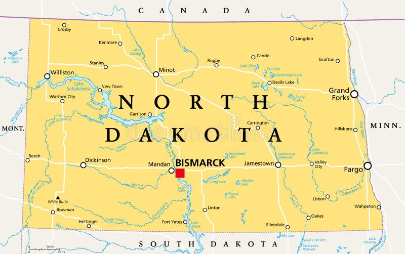
Free with trial North Dakota, ND, political map, with capital Bismarck. State in the upper Midwest subregion of the United States of America, nicknamed Peace Garden State, Roughrider State and Heaven on Earth. Vector. Mapping vectors North Dakota, ND, political map, US state, Peace Garden State. North Dakota, ND, political map, with capital Bismarck. State in the upper Midwest subregion of. North Dakota, ND, political map, with capital Bismarck. State in the upper Midwest subregion of the United States of America, nicknamed Peace Garden State, Roughrider State and Heaven on Earth. Vector
Free with trial Northern Europe, political map. British Isles, Fennoscandia, Jutland peninsula, Baltic plain lying to the east, and the islands offshore from mainland Northern Europe and the main European continent. Mapping vectors Northern Europe, political map. British Isles, Fennoscandia, Jutland peninsula, Baltic plain lying to the east, and the islands offshore from mainland Northern
Free with trial Navigation map horizontal. Vector illustration of website horizontal banner for navigation application or program with city map and route planning. Mapping vectors Navigation map horizontal. Vector illustration of website horizontal banner for navigation application or program with city map and route planning
Free with trial Pixelated world map in vector format. Two pixelated world map images in vector format. Mapping vectors Pixelated world map in vector format. Two pixelated world map images in vector format
Free with trial Pin on the map. Route location icon, three map pin sign and road, journey symbol, one color vector illustration isolated on white background. Mapping vectors Pin on the map. Route location icon, three map pin sign and road, journey symbol, one color vector illustration isolated on white background
Free with trial Vintage Color Political Map of USA and Flat Map Pointers with water objects, cities and capitals. Mapping vectors Vintage Color Political Map of USA and Flat Map Pointers. With water objects, cities and capitals
Free with trial North America, gray political map with borders of the states, provinces and territories of Canada, USA and Mexico. Continent bordered by South America, Caribbean Sea, Arctic, Atlantic and the Pacific. Mapping vectors North America, states, provinces, and territories, gray political map. North America, gray political map with borders of the states, provinces and territories of. North America, gray political map with borders of the states, provinces and territories of Canada, USA and Mexico. Continent bordered by South America, Caribbean Sea, Arctic, Atlantic and the Pacific.
Free with trial Vector flower pattern. Seamless flower pattern in magenta and cyan colour with additional vector file. Mapping vectors Vector flower pattern. Seamless flower pattern in magenta and cyan colour with additional vector file
Free with trial Seamless floral red vector background. Abstract seamless floral red vector background. Mapping vectors Seamless floral red vector background. Abstract seamless floral red vector background
Free with trial Poland Physical Map Isolated On White. Highly detailed map vector illustration. Image contains layers with shaded contours, land names, city names, water objects and it`s names, highways. Mapping vectors Poland Physical Map Isolated On White. Highly detailed map vector illustration. Image contains layers with shaded contours, land names, city names, water
Free with trial Texas icon on blue cracked web button. Mapping vectors Texas icon on blue cracked web button. Texas icon on blue cracked web icon
Free with trial City map Detroit, travel vector poster design. Detailed city plan for design. Mapping vectors City map Detroit, travel vector poster design. Detailed city plan for design
Free with trial Travel poster, urban street plan city map Chicago and Detroit, vector illustration. Detailed city plan for design. Mapping vectors Travel poster, urban street plan city map Chicago and Detroit, vector illustration. Detailed city plan for design
Free with trial Northern Europe, subregion and geoscheme, political map. The islands offshore from mainland Northern Europe and countries of the main European continent. Color division for statistical purposes. Mapping vectors Northern Europe, subdivision and geoscheme, political map. Northern Europe, subregion and geoscheme, political map. The islands offshore from mainland Northern. Northern Europe, subregion and geoscheme, political map. The islands offshore from mainland Northern Europe and countries of the main European continent. Color division for statistical purposes.
Free with trial Vector illustration concept of man holding smartphone in hand with gps navigation. Mapping vectors Vector concept of gps navigation on smartphone. Vector illustration concept of man holding smartphone in hand with gps navigation. Vector illustration concept of man holding smartphone in hand with gps navigation.
Free with trial Circle group design set. Can use for brochure and business project background. Mapping vectors Circle group design set. Can use for brochure and business project background
Free with trial Map of California State - Highly Detailed Map of California State vector illustration - All elements are separated in editable layers clearly labeled. Mapping vectors Map of California State. Highly Detailed vector illustration - All elements are separated in editable layers clearly labeled. Map of California State - Highly Detailed Map of California State vector illustration - All elements are separated in editable layers clearly labeled
Free with trial California Physical Map - Highly Detailed Relief Map of California State vector illustration - All elements are separated in editable layers clearly labeled. Mapping vectors California Physical Map. Highly Detailed Relief Map of California State vector illustration - All elements are separated in editable layers clearly labeled
Free with trial South Carolina counties, gray political map with borders and county names. State in the Southeastern region of the United States, subdivided into 46 counties. Nicknamed The Palmetto State. Vector. Mapping vectors South Carolina, U. S. state subdivided into 46 counties, gray political map. South Carolina counties, gray political map with borders and county names. State in. South Carolina counties, gray political map with borders and county names. State in the Southeastern region of the United States, subdivided into 46 counties. Nicknamed The Palmetto State. Vector
Free with trial Travel poster, urban street plan city map Rio de Janeiro and Sao Paulo, vector illustration. For decorating walls. Mapping vectors Travel poster, urban street plan city map Rio de Janeiro and Sao Paulo, vector illustration. For decorating walls
Free with trial Location route A to B, start o finish. Simple ashed line trace and walking routes isolated on white background. Symbol of route. Thin line icon of symbols. Premium mono linear destination set. Mapping vectors Location route A to B, start o finish. Simple bashed line. Location route A to B, start o finish. Simple ashed line trace and walking routes isolated on white. Location route A to B, start o finish. Simple ashed line trace and walking routes isolated on white background. Symbol of route. Thin line icon of symbols. Premium mono linear destination set.
Free with trial Set of travel posters with Sydney, detailed urban street plan city map, Silhouette city skyline, vector artwork, set 2. For decorating walls. Mapping vectors Set of travel posters with Sydney, detailed urban street plan city map, Silhouette city skyline, vector artwork, set 2. For decorating walls
Free with trial Europe Black Map. No text. Detailed illustration of Europe Map. Mapping vectors Europe Black Map. No text. Detailed illustration of Europe Map
Free with trial Vector set of spring bamboo forest scene on oblique projection. Images are designed to align into square grid for easy game tile-mapping. Mapping vectors Bamboo Forest Plants Set. Vector set of spring bamboo forest scene on oblique projection. Images are designed to align into square grid for easy game tile. Vector set of spring bamboo forest scene on oblique projection. Images are designed to align into square grid for easy game tile-mapping.
Free with trial Medical Healthcare Icons. Medical Banner with People Charting Disease or Scientific Discovery Web Header Banner. Vector Illustration. Healthcare Concept. Mapping vectors Medical Healthcare Icons. Medical Banner with People Charting Disease or Scientific Discovery Web Header Banner. Vector Illustration. Healthcare Concept
Free with trial Gaza Strip political map. Self governing Palestinian territory on the coast of Mediterranean Sea that borders to Israel and Egypt. Claimed by State of Palestine. English labeling. Illustration. Vector. Mapping vectors Gaza Strip political map. Self governing Palestinian territory on the coast of Mediterranean Sea that borders to Israel and Egypt. Claimed by State of
Free with trial Alabama State Map and location pin icons. Vector illustration. Mapping vectors Alabama State Map and location pin icons. Vector illustration
Free with trial Map of California State and Colored Map Icons - Highly Detailed Map of California State vector illustration - All elements are separated in editable layers clearly labeled. Mapping vectors Map of California State and Colored Map Icons. Highly Detailed Map of California State vector illustration - All elements are separated in editable layers
Free with trial Missouri, subdivided into 114 counties and the independent city St. Louis, gray political map. State in the Midwestern region of United States, Show Me State, Cave State, and Mother of the West. Mapping vectors Missouri, subdivided into 114 counties and St. Louis City, gray political map. Missouri, subdivided into 114 counties and the independent city St. Louis, gray. Missouri, subdivided into 114 counties and the independent city St. Louis, gray political map. State in the Midwestern region of United States, Show Me State, Cave State, and Mother of the West.
Free with trial Set of travel posters with Istanbul, detailed urban street plan city map, Silhouette city skyline, vector artwork, set 2. For decorating walls. Mapping vectors Set of travel posters with Istanbul, detailed urban street plan city map, Silhouette city skyline, vector artwork, set 2. For decorating walls
Free with trial China Physical Map. No text. High detailed China Relief Map. Mapping vectors China Physical Map. No text. High detailed China Relief Map
Free with trial A simple 3D map of North Rhine-Westphalia. Mapping vectors Map_North Rhine-Westphalia. A simple 3D map of North Rhine-Westphalia. A simple 3D map of North Rhine-Westphalia.
Free with trial Oval world map projection. Black and white world map vector illustration. Mapping vectors Oval world map projection. Black and white world map vector illustration
Free with trial Vector illustration of horizontal banner for travel devices with different landmarks and destinations with navigation and booking options. Mapping vectors Travel devices horizontal. Vector illustration of horizontal banner for travel devices with different landmarks and destinations with navigation and booking. Vector illustration of horizontal banner for travel devices with different landmarks and destinations with navigation and booking options
Free with trial Blackboard chalk mind map seamless pattern. Vector blackboard chalk mind map seamless pattern background with hand drawn elements. Mapping vectors Blackboard chalk mind map seamless pattern. Vector blackboard chalk mind map seamless pattern background with hand drawn elements
Free with trial Set of travel posters with Barcelona, detailed urban street plan city map, Silhouette city skyline, vector artwork, set 2. For decorating walls. Mapping vectors Set of travel posters with Barcelona, detailed urban street plan city map, Silhouette city skyline, vector artwork, set 2. For decorating walls
Free with trial Czech Republic Physical Map - Detailed map of Czech Republic vector illustration - All elements are separated in editable layers clearly labeled. Mapping vectors Czech Republic Physical Map. Detailed map of Czech Republic vector illustration - All elements are separated in editable layers clearly labeled
Free with trial Colorful navigation 3D pins. Set of mapping pointers. Vector Illustration. Mapping vectors Colorful navigation 3D pins. Set of mapping pointers.Vector Illustration
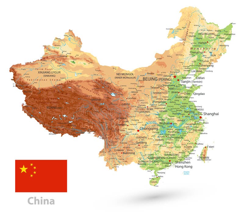
Free with trial China Physical Map. on white. High detailed China Relief map with labeling. Mapping vectors China Physical Map. on white. High detailed China Relief map with labeling
Free with trial World Map - Hammer Projection. A black and white vector world map in Hammer projection. Mapping vectors World Map - Hammer Projection. A black and white vector world map in Hammer projection
Free with trial Decoding Medical DNA Test flat illustration. Decoding DNA spiral from a flask with biological materials. DNA test flat illustration. Mapping vectors Decoding Medical DNA Test flat illustration. Decoding DNA spiral from a flask with biological materials. DNA test flat illustration
Free with trial Blackboard chalk mind map vertical seamless. Vector blackboard chalk mind map vertical seamless pattern background border with hand drawn elements. Mapping vectors Blackboard chalk mind map vertical seamless. Vector blackboard chalk mind map vertical seamless pattern background border with hand drawn elements
Free with trial Corfu, island of Greece, political map. Also known as Kerkyra, a Greek island in the Ionian Sea and part of the Ionian Islands. With Othonoi, Ereikoussa and Mathraki it forms the Corfu Regional Unit. Mapping vectors Corfu, island of Greece and part of Ionian Islands, political map. Corfu, island of Greece, political map. Also known as Kerkyra, a Greek island in the Ionian. Corfu, island of Greece, political map. Also known as Kerkyra, a Greek island in the Ionian Sea and part of the Ionian Islands. With Othonoi, Ereikoussa and Mathraki it forms the Corfu Regional Unit.
Free with trial Wisconsin, WI, political map, with the capital Madison and metropolitan area Milwaukee. State in the upper Midwestern United States of America, with the nicknames Badger State, and Americas Dairyland. Mapping vectors Wisconsin, WI, political map, US state, with the nickname Badger State. Wisconsin, WI, political map, with the capital Madison and metropolitan area Milwaukee. Wisconsin, WI, political map, with the capital Madison and metropolitan area Milwaukee. State in the upper Midwestern United States of America, with the nicknames Badger State, and Americas Dairyland.
Free with trial Globe christmas ball. Vector illustration (eps 10). Mapping vectors Globe christmas ball. Vector illustration (eps 10
Free with trial Set of travel posters with Copenhagen, detailed urban street plan city map, Silhouette city skyline, vector artwork, set 2. For decorating walls. Mapping vectors Set of travel posters with Copenhagen, detailed urban street plan city map, Silhouette city skyline, vector artwork, set 2. For decorating walls
Free with trial Blank red GPS navigation and map flat icon, isolated on white background. Eps file available. Mapping vectors Red Blank GPS Flat Icon Isolated on White. Blank red GPS navigation and map flat icon, isolated on white background. Eps file available. Blank red GPS navigation and map flat icon, isolated on white background. Eps file available.
Free with trial Southeast Asia, political map with borders. Subregion of Asia with countries south of China, east of India, west of New Guinea, north of Australia. Gray illustration on white background. Vector. Mapping vectors Southeast Asia political map. Southeast Asia, political map with borders. Subregion of Asia with countries south of China, east of India, west of New Guinea. Southeast Asia, political map with borders. Subregion of Asia with countries south of China, east of India, west of New Guinea, north of Australia. Gray illustration on white background. Vector.
Free with trial Texas icon on green and black arrows. Green and black arrow banners with texas icons. Mapping vectors Texas icon on green and black arrows. Green and black arrow banners with texas icons
Free with trial Graph step vector template with icon. Can use for brochure and business project background. Mapping vectors Graph step vector template with icon. Can use for brochure and business project background
Free with trial Melanesia, subregion of Oceania, political map. Extending from New Guinea in southwestern Pacific Ocean to Tonga, including Fiji, Vanuatu, Solomon Islands and Papua New Guinea. Illustration. Vector. Mapping vectors Melanesia, subregion of Oceania, political map. Extending from New Guinea in southwestern Pacific Ocean to Tonga, including Fiji, Vanuatu, Solomon Islands and
Free with trial California Physical Map Vinatge Colors - Blank Map - Detailed Relief Map of California State vector illustration - All elements are separated in editable layers clearly labeled. Mapping vectors California Physical Map Vinatge Colors - Blank Map. Detailed Relief Map of California State vector illustration - All elements are separated in editable
Free with trial Gulf States of the United States, also called Gulf South or South Coast, political map. Coastline along Southern United States at Gulf of Mexico. Texas, Louisiana, Mississippi, Alabama and Florida. Mapping vectors Gulf States of the USA, Gulf South or South Coast, gray political map. Gulf States of the United States, also called Gulf South or South Coast, political map. Gulf States of the United States, also called Gulf South or South Coast, political map. Coastline along Southern United States at Gulf of Mexico. Texas, Louisiana, Mississippi, Alabama and Florida.
Free with trial Circle loop with icon. Can use for brochure and business project background. Mapping vectors Circle loop with icon. Can use for brochure and business project background
Free with trial Knowledge graph concept with outline icons showing network, hierarchy, central source, intersection, and structured data. Outline icons set. Mapping vectors Knowledge graph concept with outline icons showing network, hierarchy, central ... Knowledge graph concept with outline icons showing network, hierarchy. Knowledge graph concept with outline icons showing network, hierarchy, central source, intersection, and structured data. Outline icons set
Free with trial West Virginia counties, political map with borders and county names. Landlocked state in the Southeastern and Mid-Atlantic regions of the United States, subdivided into 55 counties. Illustration. Mapping vectors West Virginia, U.S. state subdivided into 55 counties, political map. West Virginia counties, political map with borders and county names. Landlocked state in. West Virginia counties, political map with borders and county names. Landlocked state in the Southeastern and Mid-Atlantic regions of the United States, subdivided into 55 counties. Illustration
Free with trial West Virginia, WV, political map. State in the Appalachian region of Southern United States of America. Part of Mid-Atlantic Southeast Region. Capital Charleston. Mountain State. Illustration. Vector. Mapping vectors West Virginia, WV, political map, Mountain State. West Virginia, WV, political map. State in the Appalachian region of Southern United States of America. Part of. West Virginia, WV, political map. State in the Appalachian region of Southern United States of America. Part of Mid-Atlantic Southeast Region. Capital Charleston. Mountain State. Illustration. Vector.
Free with trial City map Kharkiv, monochrome detailed plan, vector illustration. Roads, trails and rivers. Mapping vectors City map Kharkiv, monochrome detailed plan, vector illustration. Roads, trails and rivers
Free with trial The Carolinas or simply Carolina, U. S. states North and South Carolina, gray political map, with borders and capitals Raleigh and Columbia. Bordered by Virginia, Tennessee, Georgia, and the Atlantic. Mapping vectors The Carolinas, the U.S. states North and South Carolina, gray political map. The Carolinas or simply Carolina, U.S. states North and South Carolina, gray. The Carolinas or simply Carolina, U.S. states North and South Carolina, gray political map, with borders and capitals Raleigh and Columbia. Bordered by Virginia, Tennessee, Georgia, and the Atlantic.
Free with trial Blank green GPS navigation and map flat icon, isolated on white background. Eps file available. Mapping vectors Green Blank GPS Flat Icon Isolated on White. Blank green GPS navigation and map flat icon, isolated on white background. Eps file available. Blank green GPS navigation and map flat icon, isolated on white background. Eps file available.
Free with trial North Carolina counties, political map with borders county names. State in the Southeastern region of United States, subdivided into 100 counties. Nicknamed The Tar Heel State and The Old North State. Mapping vectors North Carolina, subdivided into 100 counties, political map. North Carolina counties, political map with borders county names. State in the Southeastern region. North Carolina counties, political map with borders county names. State in the Southeastern region of United States, subdivided into 100 counties. Nicknamed The Tar Heel State and The Old North State.
Free with trial Cook Islands political map with capital Avarua. Self-governing island country in South Pacific Ocean in free association with New Zealand, comprising 15 islands. English labeling. Illustration. Vector. Mapping vectors Cook Islands political map with capital Avarua. Self-governing island country in South Pacific Ocean in free association with New Zealand, comprising 15
Free with trial United States divided in Census regions and divisions, gray map. Region definition used for data collection and analysis. Most commonly used classification system. English. Illustration. Vector. Mapping vectors United States divided in Census regions and divisions, gray map. Region definition used for data collection and analysis. Most commonly used classification
Free with trial China Physical Map Retro Colors. High detailed China Relief map with labeling. Mapping vectors China Physical Map Retro Colors. High detailed China Relief map with labeling
Free with trial Silicon Valley, a region in Northern California, political map. Global center for high technology and innovation in the United States, located in the southern part of the San Francisco Bay Area. Mapping vectors Silicon Valley, a region in Northern California, USA, political map. Silicon Valley, a region in Northern California, political map. Global center for high. Silicon Valley, a region in Northern California, political map. Global center for high technology and innovation in the United States, located in the southern part of the San Francisco Bay Area.
 Sign in