Free with trial Dragonfly and foliage vector background. Foliage and dragonfly isolated on black background vector. Mapping vectors Dragonfly and foliage vector background. Foliage and dragonfly isolated on black background vector
Free with trial A stylized map of the greek island Corfu. Vector file also available. Mapping vectors Map Corfu. A stylized map of the greek island Corfu. Vector file also available. A stylized map of the greek island Corfu. Vector file also available.
Free with trial Southeast region of United States, colored map. Also Southeastern United States, American Southeast, or simply Southeast, a geographic region, consisting of 12 contiguous states, and Washington, D. C. Mapping vectors Southeast region of the United States, multi colored map. Southeast region of United States, colored map. Also Southeastern United States, American Southeast, or. Southeast region of United States, colored map. Also Southeastern United States, American Southeast, or simply Southeast, a geographic region, consisting of 12 contiguous states, and Washington, D.C.
Free with trial The Wheel of Emotions diagram outlines emotions like joy, trust, and fear. Key elements, emotion names, color-coded sections. Outline diagram. Mapping vectors The Wheel of Emotions diagram outlines emotions like joy, trust, ... The Wheel of Emotions diagram outlines emotions like joy, trust, and fear. Key elements. The Wheel of Emotions diagram outlines emotions like joy, trust, and fear. Key elements, emotion names, color-coded sections. Outline diagram
Free with trial State of Alabama, subdivided into 67 counties, outline map with county borders and names. State in the Southeastern region of the United States, nicknamed The Yellowhammer State, and Heart of Dixie. Mapping vectors State of Alabama, subdivided into 67 counties, outline map. With county borders and names. State in the Southeastern region of the United States, nicknamed The. State of Alabama, subdivided into 67 counties, outline map with county borders and names. State in the Southeastern region of the United States, nicknamed The Yellowhammer State, and Heart of Dixie.
Free with trial Tajikistan map. Administrative division of the Republic of Tajikistan. Mapping vectors Tajikistan map. Administrative division of the Republic of Tajikistan
Free with trial Azerbaijan map. Administrative division of the Republic of Azerbaijan. Mapping vectors Azerbaijan map. Administrative division of the Republic of Azerbaijan
Free with trial Habit change is shown by comparing old and new habit loops using gears, arrows, and icons to illustrate cue, craving, response, and reward. Outline diagram. Mapping vectors Habit change is shown by comparing old and new habit ... Habit change is shown by comparing old and new habit loops using gears, arrows, and icons to illustrate. Habit change is shown by comparing old and new habit loops using gears, arrows, and icons to illustrate cue, craving, response, and reward. Outline diagram
Free with trial Tohoku, region of Japan, political map. Also known as Northeast region, Ou region, or Northeast Japan, consisting of the six prefectures Akita, Aomori, Fukushima, Iwate, Miyagi, and Yamagata. Vector. Mapping vectors Tohoku, region of Japan, political map of Northeast Japan. Tohoku, region of Japan, political map. Also known as Northeast region, Ou region, or Northeast Japan. Tohoku, region of Japan, political map. Also known as Northeast region, Ou region, or Northeast Japan, consisting of the six prefectures Akita, Aomori, Fukushima, Iwate, Miyagi, and Yamagata. Vector
Free with trial Japan, an island country in East Asia, political map, with capital Tokyo and the main islands Honshu, Hokkaido, Kyushu, Shikoku and Okinawa. An archipelago of 14,125 in the North Pacific Ocean. Vector. Mapping vectors Japan, island country in East Asia, political map. Japan, an island country in East Asia, political map, with capital Tokyo and the main islands Honshu, Hokkaido. Japan, an island country in East Asia, political map, with capital Tokyo and the main islands Honshu, Hokkaido, Kyushu, Shikoku and Okinawa. An archipelago of 14,125 in the North Pacific Ocean. Vector
Free with trial Military-style topographic map with contour lines, elevation data, and coordinates. Ideal for war strategy visuals, navigation design, and tactical planning interfaces. Battlefield top view green UI. Mapping vectors Topographic military map background. Military-style topographic map with contour lines, elevation data, and coordinates. Ideal for war strategy visuals. Military-style topographic map with contour lines, elevation data, and coordinates. Ideal for war strategy visuals, navigation design, and tactical planning interfaces. Battlefield top view green UI.
Free with trial Travel poster, urban street plan city map Sheffield and Liverpool, vector illustration. For decorating walls. Mapping vectors Travel poster, urban street plan city map Sheffield and Liverpool, vector illustration. For decorating walls
Free with trial Administrative division of Turkmenistan, is one of the Turkic states in Central Asia. Mapping vectors Turkmenistan map. Administrative division of Turkmenistan, is one of the Turkic states in Central Asia. Administrative division of Turkmenistan, is one of the Turkic states in Central Asia.
Free with trial Set of travel posters with Reykjavik, detailed urban street plan city map, Silhouette city skyline, vector artwork. For decorating walls. Mapping vectors Set of travel posters with Reykjavik, detailed urban street plan city map, Silhouette city skyline, vector artwork. For decorating walls
Free with trial Anchorage and Kenai Peninsula, gray political map. Anchorage, most populous city of Alaska, and the Kenai Peninsula in the south, separated from mainland between Cook Inlet and Prince William Sound. Mapping vectors Anchorage and Kenai Peninsula, Alaska, gray political map. Anchorage and Kenai Peninsula, gray political map. Anchorage, most populous city of Alaska, and the. Anchorage and Kenai Peninsula, gray political map. Anchorage, most populous city of Alaska, and the Kenai Peninsula in the south, separated from mainland between Cook Inlet and Prince William Sound.
Free with trial Meshes. Vector background of a bulging mesh pattern. Mapping vectors Meshes. Vector background of a bulging mesh pattern
Free with trial Connecting people with each other illustration. Mapping vectors Connecting people with each other illustration
Free with trial Spain, total solar eclipse, August 12, 2026, path of totality, map with cities. Moon fully obscuring the sun, crossing from west to east through northern half of Spain, including the Balearic Islands. Mapping vectors Spain, total solar eclipse, August 12, 2026, path of totality, map. With cities. Moon fully obscuring the sun, crossing from west to east through northern half. Spain, total solar eclipse, August 12, 2026, path of totality, map with cities. Moon fully obscuring the sun, crossing from west to east through northern half of Spain, including the Balearic Islands.
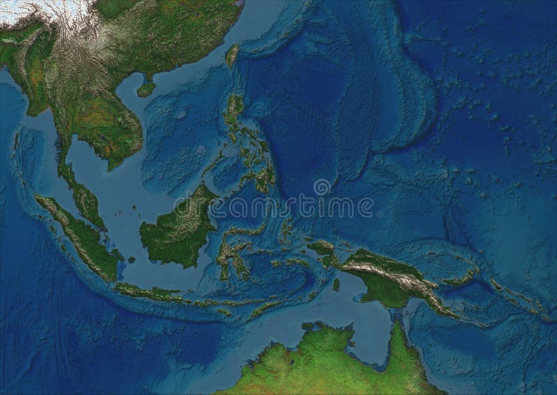
Free with trial A physical map of the greater region of South East Asia (plus partially Northern Australia) without borders or country names. It's product of 10+ years mapmaking practice made in Germany. The details and colors are superb and it looks pseudo three dimensional. The format of the map according to ISO 216 standard is A series, means it's usable as DIN A4, A3, A2 format and so on. Mapping vectors South East Asia - physical map. A physical map of the greater region of South East Asia (plus partially Northern Australia) without borders or country names. It'. A physical map of the greater region of South East Asia (plus partially Northern Australia) without borders or country names. It's product of 10+ years mapmaking practice made in Germany. The details and colors are superb and it looks pseudo three dimensional. The format of the map according to ISO 216 standard is A series, means it's usable as DIN A4, A3, A2 format and so on.
Free with trial Visual learning pathway shows how inputs become outputs through processing, head silhouette, gears, and lightbulb highlight cognition and insight. Outline diagram. Mapping vectors Visual learning pathway shows how inputs become outputs through processing, ... Visual learning pathway shows how inputs become outputs through processing, head. Visual learning pathway shows how inputs become outputs through processing, head silhouette, gears, and lightbulb highlight cognition and insight. Outline diagram
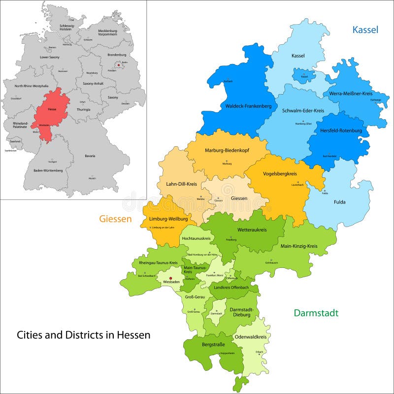
Free with trial State of Germany - Hesse. Administrative division of Germany. Map of Hesse with cities and districts. Mapping vectors State of Germany - Hesse. Administrative division of Germany. Map of Hesse with cities and districts
Free with trial Face reflexology chart. Female face with colored areas and names of corresponding internal organs. Alternative acupressure and physiotherapy health treatment. Vector on white. Mapping vectors Face Reflexology Female Face Internal Organs Areas Chart. Face reflexology chart. Female face with colored areas and names of corresponding internal organs. Face reflexology chart. Female face with colored areas and names of corresponding internal organs. Alternative acupressure and physiotherapy health treatment. Vector on white.
Free with trial Chugoku, region of Japan, gray political map. Also known as Sanin-Sanyo region, the westernmost region of Honshu, consisting of the prefectures of Hiroshima, Okayama, Shimane, Tottori, and Yamaguchi. Mapping vectors Chugoku, region of Japan, gray political map. Also known as Sanin-Sanyo region, the westernmost region of Honshu, consisting of the prefectures of Hiroshima
Free with trial Seamless background with butterfly. Colorful illustration. Mapping vectors Seamless background with butterfly. Colorful illustration
Free with trial Set of travel posters with Amsterdam, detailed urban street plan city map, Silhouette city skyline, vector artwork, set 2. For decorating walls. Mapping vectors Set of travel posters with Amsterdam, detailed urban street plan city map, Silhouette city skyline, vector artwork, set 2. For decorating walls
Free with trial State of Germany - Saarland. Administrative division of Germany. Map of Saarland with cities and districts. Mapping vectors State of Germany - Saarland. Administrative division of Germany. Map of Saarland with cities and districts
Free with trial Systems thinking iceberg shows events, patterns, structures, and mental models. Doodle style diagram. Mapping vectors Systems thinking iceberg shows events, patterns, structures, and mental models. ... Systems thinking iceberg shows events, patterns, structures, and mental. Systems thinking iceberg shows events, patterns, structures, and mental models. Doodle style diagram.
Free with trial Bosnia and Herzegovina map with labelled border regions, white background. Mapping vectors Bosnia and Herzegovina map. With labelled border regions, white background
Free with trial Political Map of USA and Flat Map Pointers with water objects, cities and capitals. Mapping vectors Political Map of USA and Flat Map Pointers. With water objects, cities and capitals
Free with trial Sahara, Sahel, and Sub-Saharan Africa, colored political map. Sahara, largest hot desert in the world, and most of North Africa. South of it the Sahelian acacia savanna, part of Sub-Saharan Africa. Mapping vectors Sahara, Sahel, and Sub-Saharan Africa, political map. Sahara, Sahel, and Sub-Saharan Africa, colored political map. Sahara, largest hot desert in the world, and. Sahara, Sahel, and Sub-Saharan Africa, colored political map. Sahara, largest hot desert in the world, and most of North Africa. South of it the Sahelian acacia savanna, part of Sub-Saharan Africa.
Free with trial Seamless floral light vector background. Mapping vectors Seamless floral light vector background. Seamless floral light pink vector background
Free with trial Travel poster, urban street plan city map Frankfurt am Main and Munich, vector illustration. For design. Mapping vectors Travel poster, urban street plan city map Frankfurt am Main and Munich, vector illustration. For design
Free with trial Seamless vector background with butterfly. Colorful illustration. Mapping vectors Seamless vector background with butterfly. Colorful illustration
Free with trial Set of travel posters with Dubai, detailed urban street plan city map, Silhouette city skyline, vector artwork, collection of wall tourist decorations. Mapping vectors Set of travel posters with Dubai, detailed urban street plan city map, Silhouette city skyline, vector artwork. Collection of wall tourist decorations
Free with trial Set of travel posters with Milan, detailed urban street plan city map, Silhouette city skyline, vector artwork, collection of art wall tourist decorations. Mapping vectors Set of travel posters with Milan, detailed urban street plan city map, Silhouette city skyline, vector artwork. Collection of art wall tourist decorations
Free with trial State of New Jersey, subdivided into 21 counties, outline map. State in the Mid-Atlantic and Northeastern region of the United States, nicknamed The Garden State. Map with borders and county names. Mapping vectors State of New Jersey, subdivided into 21 counties, outline map. State in the Mid-Atlantic and Northeastern region of the United States, nicknamed The Garden
Free with trial Nine regions of the United States, multi colored map. West Coast, Rocky Mountain, Great Plains, Midwest, Mid-Atlantic, New England, Alaska and Hawaii, Southwest, and the South. Isolated illustration. Mapping vectors Nine regions of the United States, multi colored map. West Coast, Rocky Mountain, Great Plains, Midwest, Mid-Atlantic, New England, Alaska and Hawaii
Free with trial Mainland Southeast Asia, northern part of formerly known Indochina, gray political map. The countries Thailand, Vietnam, Myanmar, Laos, and Cambodia, with borders, their capitals and largest cities. Mapping vectors Mainland Southeast Asia, gray political map. Mainland Southeast Asia, northern part of formerly known Indochina, gray political map. The countries Thailand. Mainland Southeast Asia, northern part of formerly known Indochina, gray political map. The countries Thailand, Vietnam, Myanmar, Laos, and Cambodia, with borders, their capitals and largest cities.
Free with trial Persian Gulf region, multi colored political map. Arabian Gulf, a sea in West Asia, located between Iran and the Arabian Peninsula, connected to the Gulf of Oman in the east by the Strait of Hormuz. Mapping vectors Persian Gulf region, and the Strait of Hormuz, multi colored map. Persian Gulf region, multi colored political map. Arabian Gulf, a sea in West Asia, located. Persian Gulf region, multi colored political map. Arabian Gulf, a sea in West Asia, located between Iran and the Arabian Peninsula, connected to the Gulf of Oman in the east by the Strait of Hormuz.
Free with trial Set of travel posters with Rome, detailed urban street plan city map, Silhouette city skyline, vector artwork, set 2. For decorating walls. Mapping vectors Set of travel posters with Rome, detailed urban street plan city map, Silhouette city skyline, vector artwork, set 2. For decorating walls
Free with trial Textured foliage vector. Foliage with wheat isolated on textured background in vector format. Mapping vectors Textured foliage vector. Foliage with wheat isolated on textured background in vector format
Free with trial Seamless floral rose background. Colorful illustration. Mapping vectors Seamless floral rose background. Colorful illustration
Free with trial Northeast region of the United States, multi colored map. Also known as the Northeast, the East Coast, or the American Northeast. Geographic region of the USA, consisting of 11 contiguous states. Mapping vectors Northeast, geographical region of the United States, multi colored map. Northeast region of the United States, multi colored map. Also known as the Northeast. Northeast region of the United States, multi colored map. Also known as the Northeast, the East Coast, or the American Northeast. Geographic region of the USA, consisting of 11 contiguous states.
Free with trial Stylized map of lake Constance and surroundings. Showing various cities. German caption. Mapping vectors Stylized map of lake Constance and surroundings. Showing various cities. German caption
Free with trial Regions of the United States of America, political map. The nine regions New England, Great Plains, Rocky Mountain, Mid Atlantic, South, West Coast, Midwest, Southwest, Alaska and Hawaii. Illustration. Mapping vectors Regions of the United States of America, political map. The nine regions New England, Great Plains, Rocky Mountain, Mid Atlantic, South, West Coast, Midwest
Free with trial State of Maine subdivided into 16 counties, outline map. State in the New England region of the United States, nicknamed The Pine Tree State, and Vacationland. Map with boundaries and county names. Mapping vectors State of Maine subdivided into 16 counties, outline map. State in the New England region of the United States, nicknamed The Pine Tree State, and Vacationland
Free with trial Travel poster, urban street plan city map Athens and Istanbul, vector illustration. For design. Mapping vectors Travel poster, urban street plan city map Athens and Istanbul, vector illustration. For design
Free with trial Line icons set with flat design elements of outdoor adventure, tourist trip, hiking equipment, mountain climbing, forest and terrain map, river rafting. Modern vector logo pictogram collection concept. Mapping vectors Outdoor adventure line icons set. Line icons set with flat design elements of outdoor adventure, tourist trip, hiking equipment, mountain climbing, forest and. Line icons set with flat design elements of outdoor adventure, tourist trip, hiking equipment, mountain climbing, forest and terrain map, river rafting. Modern vector logo pictogram collection concept.
Free with trial Editable mind map with white clouds and lighting. The diagram in the form of mind map with five blank white clouds linked with lightning. Mapping vectors Editable mind map with white clouds and lighting. The diagram in the form of mind map with five blank white clouds linked with lightning
Free with trial Georgia with capital Tbilisi, political map. Country in Eastern Europe and West Asia, part of Caucasus region. With autonomous republics of Abkhazia and Adjara, and independent region South Ossetia. Mapping vectors Georgia, a country in the Caucasus region, political map. Georgia with capital Tbilisi, political map. Country in Eastern Europe and West Asia, part of Caucasus. Georgia with capital Tbilisi, political map. Country in Eastern Europe and West Asia, part of Caucasus region. With autonomous republics of Abkhazia and Adjara, and independent region South Ossetia.
Free with trial World maps series. South America map with ethnic ornaments. Mapping vectors World maps series. South America map with ethnic ornaments
Free with trial World map with radial dot pattern on steel blue background. White dots going from the center outwards and form the silhouette of the surface of the Earth except Antarctica under Robinson projection. Mapping vectors World map with radial dot pattern on steel blue background. White dots going from the center outwards and form the silhouette of the surface of the Earth
Free with trial Ancient Greek colonies and parent cities, history map. Greek colonization during the Archaic period, 750 to 550 BC, across the Mediterranean Sea and the Black Sea. Areas and settlements. Illustration. Mapping vectors Ancient Greek colonies and parent cities, history map. Greek colonization during the Archaic period, 750 to 550 BC, across the Mediterranean Sea and the Black
Free with trial Travel poster, urban street plan city map Valencia and Seville, vector illustration. Detailed city plan for design. Mapping vectors Travel poster, urban street plan city map Valencia and Seville, vector illustration. Detailed city plan for design
Free with trial Set of travel posters with Belfast, detailed urban street plan city map, Silhouette city skyline, vector artwork. For design. Mapping vectors Set of travel posters with Belfast, detailed urban street plan city map, Silhouette city skyline, vector artwork. For design
Free with trial State of Germany - Mecklenburg-Vorpommern. Administrative division of Germany. Map of Mecklenburg-Vorpommern with cities and districts. Mapping vectors State of Germany - Mecklenburg-Vorpommern. Administrative division of Germany. Map of Mecklenburg-Vorpommern with cities and districts
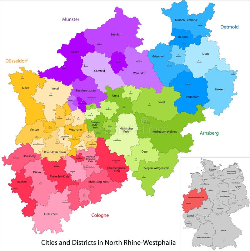
Free with trial State of Germany - North Rhine-Westphalia. Administrative division of Germany. Map of North Rhine-Westphalia with cities and districts. Mapping vectors State of Germany - North Rhine-Westphalia. Administrative division of Germany. Map of North Rhine-Westphalia with cities and districts
Free with trial Travel poster, urban street plan city map Toronto and Vancouver, vector illustration. For design. Mapping vectors Travel poster, urban street plan city map Toronto and Vancouver, vector illustration. For design
Free with trial Network Marketing concept. Pyramid as the basis of multi level marketing. Mapping vectors Pyramidal marketing. Network Marketing concept. Pyramid as the basis of multi level marketing. Network Marketing concept. Pyramid as the basis of multi level marketing.
Free with trial Travel poster, urban street plan city map Luxembourg and Reykjavik, vector illustration. For design map of roads, rivers and paths. Mapping vectors Travel poster, urban street plan city map Luxembourg and Reykjavik, vector illustration. For design map of roads, rivers and paths
Free with trial City map Liverpool, detailed urban planning travel vector poster design. For decorating walls. Mapping vectors City map Liverpool, detailed urban planning travel vector poster design. For decorating walls
Free with trial Subregions of Asia, political map. Main regions of continent Asia. North, Central, East, West, South, and Southeast Asia. Ural Mountains and River are the informal boundaries between Asia and Europe. Mapping vectors Subregions of Asia, main regions of continent Asia, political map. Subregions of Asia, political map. Main regions of continent Asia. North, Central, East, West. Subregions of Asia, political map. Main regions of continent Asia. North, Central, East, West, South, and Southeast Asia. Ural Mountains and River are the informal boundaries between Asia and Europe.
Free with trial Travel poster, urban street plan city map Boston and Philadelphia, vector illustration. For design. Mapping vectors Travel poster, urban street plan city map Boston and Philadelphia, vector illustration. For design
Free with trial The Carolinas or Carolina, the U. S. states North Carolina and South Carolina, political map, with borders and capitals Raleigh and Columbia. Bordered by Virginia, Tennessee, Georgia, and the Atlantic. Mapping vectors The Carolinas, or Carolina, the U.S. states North and South Carolina, political map. The Carolinas or Carolina, the U.S. states North Carolina and South Carolina. The Carolinas or Carolina, the U.S. states North Carolina and South Carolina, political map, with borders and capitals Raleigh and Columbia. Bordered by Virginia, Tennessee, Georgia, and the Atlantic.
Free with trial Connecting people icons set isolated ,Character cartoon, social media conceptual vector illustration. Mapping vectors Connecting people icons set isolated. Connecting people icons set isolated ,Character cartoon, social media conceptual vector illustration. Connecting people icons set isolated ,Character cartoon, social media conceptual vector illustration.
Free with trial Portugal Physical Map. Detailed vector illustration of map. Mapping vectors Portugal Physical Map. Detailed vector illustration of map
Free with trial Guyana, Suriname, and French Guiana, colorful political map. Two countries and an overseas department of France on the South American coast. With international recognized borders and disputed areas. Mapping vectors Guyana, Suriname, and French Guiana, colorful political map. Two countries and an overseas department of France on the South American coast. With international
Free with trial Thin line flat design of outdoor tourism planning, preparing necessary items for hiking trip, travel route on a map between locations. Modern vector illustration concept, isolated on white background. Mapping vectors Outdoor tourism line style illustration. Thin line flat design of outdoor tourism planning, preparing necessary items for hiking trip, travel route on a map. Thin line flat design of outdoor tourism planning, preparing necessary items for hiking trip, travel route on a map between locations. Modern vector illustration concept, isolated on white background.
Free with trial Macaronesia political map. Azores, Cape Verde, Madeira and Canary Islands. Collection of four archipelagos in the North Atlantic Ocean, off the coast of Africa. English labeling. Illustration. Vector. Mapping vectors Macaronesia political map. Azores, Cape Verde, Madeira and Canary Islands. Collection of four archipelagos in the North Atlantic Ocean, off the coast of Africa
Free with trial Major deserts of North America, political map of the Big Four, located in the Western USA and Northern Mexico. North American Desert, formed by the Great Basin, Mojave, Sonoran, and Chihuahuan deserts. Mapping vectors Major deserts of North America, political map of the Big Four. Located in the Western USA and Northern Mexico.North American Desert, formed by the Great Basin. Major deserts of North America, political map of the Big Four, located in the Western USA and Northern Mexico.North American Desert, formed by the Great Basin, Mojave, Sonoran, and Chihuahuan deserts.
Free with trial Kentucky, KY, political map with capital Frankfort and largest cities. Commonwealth of Kentucky. State in the Southeastern region of the United States of America. Bluegrass State. Illustration. Vector. Mapping vectors Kentucky, KY, political map, Bluegrass State, Southeastern US state. Kentucky, KY, political map with capital Frankfort and largest cities. Commonwealth of. Kentucky, KY, political map with capital Frankfort and largest cities. Commonwealth of Kentucky. State in the Southeastern region of the United States of America. Bluegrass State. Illustration. Vector
Free with trial Abstract and simplified world map formed by squares. Mapping vectors World Map. Abstract and simplified world map formed by squares. Abstract and simplified world map formed by squares.
Free with trial GPS Device. Easy to edit vector illustration of. Mapping vectors GPS Device. Easy to edit vector illustration of
Free with trial Geographic coordinates diagram shows Earth with longitude and latitude lines, demonstrating global position measurement. Outline diagram. Mapping vectors Geographic coordinates diagram shows Earth with longitude and latitude lines, ... Geographic coordinates diagram shows Earth with longitude and latitude lines. Geographic coordinates diagram shows Earth with longitude and latitude lines, demonstrating global position measurement. Outline diagram
Free with trial West Asia and South Asia, political map with countries, their international borders and capitals. Western or Southwest Asia, with the Middle East, and South Asia, with the Indian subcontinent. Vector. Mapping vectors West Asia, Middle East, South Asia, Indian subcontinent, political map. West Asia and South Asia, political map with countries, their international borders and. West Asia and South Asia, political map with countries, their international borders and capitals. Western or Southwest Asia, with the Middle East, and South Asia, with the Indian subcontinent. Vector
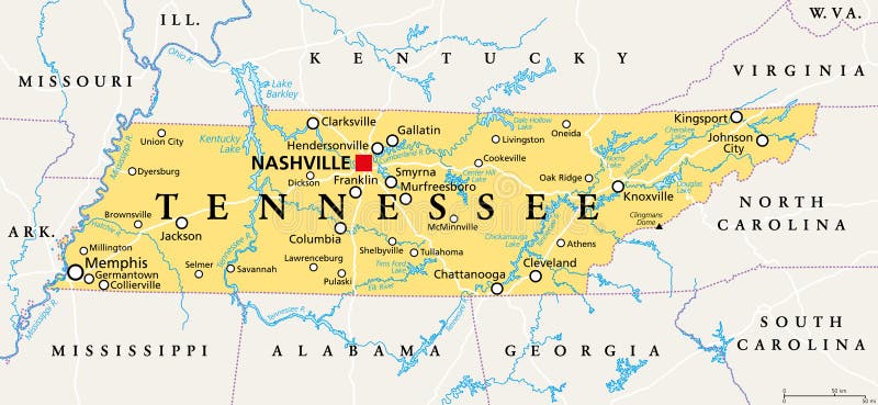
Free with trial Tennessee, TN, political map, with capital Nashville, largest cities, lakes and rivers. State of Tennessee. Landlocked state in Southeastern region of the United States, nicknamed The Volunteer State. Mapping vectors Tennessee, TN, political map, US state, nicknamed The Volunteer State. Tennessee, TN, political map, with capital Nashville, largest cities, lakes and rivers. Tennessee, TN, political map, with capital Nashville, largest cities, lakes and rivers. State of Tennessee. Landlocked state in Southeastern region of the United States, nicknamed The Volunteer State.
Free with trial Earth heart. Heart with earth mapping on blue background. Mapping vectors Earth heart. Heart with earth mapping on blue background
 Sign in