Free with trial Vector map of Xinjiang Uygur Autonomous Region, China. Mapping vectors Vector map of Xinjiang Uygur Autonomous Region, China.
Free with trial Administrative, political and street map of the Portuguese city of Porto. Mapping vectors Administrative, political and street map of the Portuguese city of Porto. Administrative, political and street vector map of the Portuguese city of Porto
Free with trial Spain - Highly detailed editable political map with labeling. Vector illustration. Mapping vectors Spain - Highly detailed editable political map with labeling. Vector illustration
Free with trial Mobile period tracker app. Woman holding phone with menstruation intimate tracker. Health care portable phone system, cartoon. Vector beauty illustration. Mapping vectors Mobile period tracker app. Woman holding phone with menstruation intimate tracker. Health care portable phone system, cartoon. Vector beauty illustration
Free with trial Darien Gap,political map. Geographical region in the Isthmus of Panama,connecting North and South America with Central America. The gap is in the Pan-American Highway of which a part were not built. Mapping vectors Darien Gap, geographical region in the Isthmus of Panama, political map. Darien Gap,political map. Geographical region in the Isthmus of Panama,connecting North. Darien Gap,political map. Geographical region in the Isthmus of Panama,connecting North and South America with Central America. The gap is in the Pan-American Highway of which a part were not built.
Free with trial High detailed Croatia physical map. Vector illustration. Mapping vectors High detailed Croatia physical map. Vector illustration
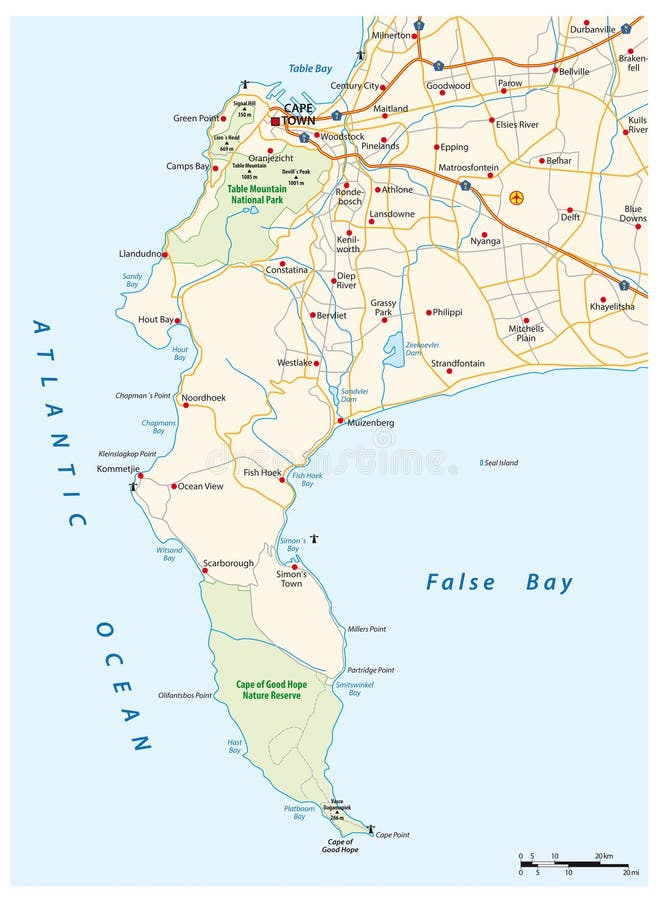
Free with trial Vector road map of Cape Peninsula, Cape Town, South Africa. Mapping vectors Vector road map of Cape Peninsula, Cape Town, South Africa.
Free with trial Colorful Norway political map with clearly labeled, separated layers. Vector illustration. Mapping vectors Colorful Norway political map with clearly labeled, separated layers. Vector illustration
Free with trial Highly detailed editable political map with separated layers. Portugal. Vector illustration. Mapping vectors Highly detailed editable political map with separated layers. Portugal. Vector illustration
Free with trial Hawaiian Islands,political map. Archipelago of eight major volcanic islands,several atolls and numerous smaller islets in the North Pacific Ocean,extending from Island of Hawaii to the Kure atoll. Mapping vectors Hawaiian Islands, archipelago in the Pacific Ocean, political map. Hawaiian Islands,political map. Archipelago of eight major volcanic islands,several atolls and. Hawaiian Islands,political map. Archipelago of eight major volcanic islands,several atolls and numerous smaller islets in the North Pacific Ocean,extending from Island of Hawaii to the Kure atoll.
Free with trial Luzon Strait,political map. Strait between Luzon and Taiwan,connecting the Philippine Sea to the South China Sea in the western Pacific Ocean. Important body of water for shipping and communications. Mapping vectors Luzon Strait, a strait between Luzon and Taiwan, political map. Luzon Strait,political map. Strait between Luzon and Taiwan,connecting the Philippine Sea to the. Luzon Strait,political map. Strait between Luzon and Taiwan,connecting the Philippine Sea to the South China Sea in the western Pacific Ocean. Important body of water for shipping and communications.
Free with trial Abstract artistic background with curled lines. Vector vintage illustration of curled vortex pattern. Marble or acrylic texture imitation. Abstract diffusion psychedelic background. Mapping vectors Abstract artistic curl background. Abstract artistic background with curled lines. Vector vintage illustration of curled vortex pattern. Marble or acrylic. Abstract artistic background with curled lines. Vector vintage illustration of curled vortex pattern. Marble or acrylic texture imitation. Abstract diffusion psychedelic background
Free with trial The Kingdom of Spain location on Europe map. Spain is a European country located in Southwestern Europe. Mapping vectors The Kingdom of Spain location on Europe map. Spain is a European country located in Southwestern Europe
Free with trial Vector road map of the Caribbean island of Grand Cayman. Mapping vectors Vector road map of the Caribbean island of Grand Cayman.
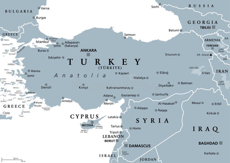
Free with trial Turkey and Syria region,gray political map. Geographic area of Anatolia,a peninsula and landmass making up most of the territory of contemporary Turkey,with neighbouring and surrounding countries. Mapping vectors Turkey and Syria region, geographic area of Anatolia, gray political map. Turkey and Syria region,gray political map. Geographic area of Anatolia,a peninsula and. Turkey and Syria region,gray political map. Geographic area of Anatolia,a peninsula and landmass making up most of the territory of contemporary Turkey,with neighbouring and surrounding countries.
Free with trial Greater Adelaide administrative map, Australia. Greater Adelaide administrative and political map, Australia. Mapping vectors Greater Adelaide administrative map, Australia. Greater Adelaide administrative and political map, Australia
Free with trial Music location concept. Blue location pin, musical note, and innovation design element showing creativity and connection. Music combining navigation, creativity and innovative technology solutions. Mapping vectors Music Location and Innovation Concept with Map Pin Symbol. Music location concept. Blue location pin, musical note, and innovation design element showing. Music location concept. Blue location pin, musical note, and innovation design element showing creativity and connection. Music combining navigation, creativity and innovative technology solutions
Free with trial Map pins, color set. 20 Map pins, color set, vector illustration. Mapping vectors Map pins, color set. 20 Map pins, color set, vector illustration
Free with trial Cyclades, group of Greek islands in the Aegean Sea, political map. Southeast of mainland Greece. Cyclades means encircling and it refers to the circle, the islands form around the sacred island Delos. Mapping vectors Cyclades, group of Greek islands in the Aegean Sea, political map. Southeast of mainland Greece. Cyclades means encircling and it refers to the circle, the
Free with trial City map Cincinnati, monochrome detailed plan, vector illustration, wall art tourist decorations. Mapping vectors City map Cincinnati, monochrome detailed plan, vector illustration. Wall art tourist decorations
Free with trial Political blank map of Europe with different colors for each country. Vector illustration. Mapping vectors Political blank map of Europe with different colors for each country. Vector illustration
Free with trial El Hierro island, political map, with capital Valverde. Nicknamed Meridian Island, part of Canary Islands, an archipelago and autonomous community of Spain, in Atlantic Ocean, off the coast of Africa. Mapping vectors El Hierro island, political map, part of the Canary Islands, Spain. El Hierro island, political map, with capital Valverde. Nicknamed Meridian Island, part of. El Hierro island, political map, with capital Valverde. Nicknamed Meridian Island, part of Canary Islands, an archipelago and autonomous community of Spain, in Atlantic Ocean, off the coast of Africa.
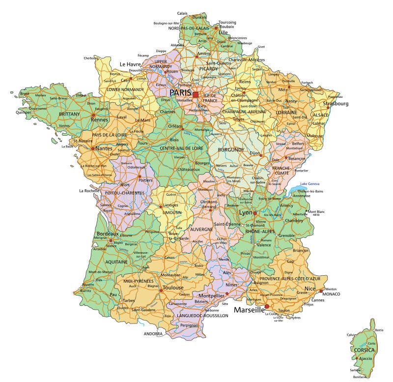
Free with trial France - Highly detailed editable political map with labeling. Vector illustration. Mapping vectors France - Highly detailed editable political map with labeling. Vector illustration
Free with trial Hokkaido Map. Map of Japan Prefecture. Vector illustration. Mapping vectors Hokkaido Map. Map of Japan Prefecture. Vector illustration
Free with trial Gulf of Naples,gray political map. Bay of Naples,located along south-western coast of Italy,opening to the Tyrrhenian Sea. Campanian volcanic arc with islands Ischia and Capri,and Mount Vesuvius. Mapping vectors Gulf of Naples, Ischia, Capri and Mount Vesuvius, Italy, gray political map. Gulf of Naples,gray political map. Bay of Naples,located along south-western coast. Gulf of Naples,gray political map. Bay of Naples,located along south-western coast of Italy,opening to the Tyrrhenian Sea. Campanian volcanic arc with islands Ischia and Capri,and Mount Vesuvius.
Free with trial Galicia administrative and political vector map, spain. Mapping vectors Galicia administrative and political vector map, spain.
Free with trial Hand holding Smartphones with mobile application search home. Find closest on city map. Flat design style modern vector illustration concept. Mapping vectors Hand holding Smartphones with mobile application search home. Find closest on city map. Flat design style modern vector illustration concept
Free with trial Colorful Tokyo administrative and political vector map. Mapping vectors Colorful Tokyo administrative and political vector map.
Free with trial High-quality design kit features a collection of six unique tree symbols rendered from a top-down aerial perspective against a solid black background. Each symbol showcases a realistic digital painting texture, combining lush layers of light green and olive foliage with organic, exposed dark brown branch and trunk structures visible beneath the canopy. The variety of leaf arrangement formats ranges from circular dense canopies to irregular, wild spreading branch layouts. This professional vector design asset is perfectly crafted for landscape architecture master plans, garden design blueprints, real estate site maps, urban forest planning overlays, and realistic environmental graphic presentations. Mapping vectors Architectural Tree Plan View Symbols with Branch Details. High-quality design kit features a collection of six unique tree symbols rendered from a top-down. high-quality design kit features a collection of six unique tree symbols rendered from a top-down aerial perspective against a solid black background. Each symbol showcases a realistic digital painting texture, combining lush layers of light green and olive foliage with organic, exposed dark brown branch and trunk structures visible beneath the canopy. The variety of leaf arrangement formats ranges from circular dense canopies to irregular, wild spreading branch layouts. This professional vector design asset is perfectly crafted for landscape architecture master plans, garden design blueprints, real estate site maps, urban forest planning overlays, and realistic environmental graphic presentations.
Free with trial Romanian map. Isolated on white background. Mapping vectors Romanian map. Isolated on white background
Free with trial Central America countries,colored political map. Subregion of the Americas,between Mexico and Colombia,consisting of Belize,Guatemala,Honduras,El Salvador,Nicaragua,Costa Rica and Panama. Mapping vectors Central America countries, subregion of the Americas, political map. Central America countries,colored political map. Subregion of the Americas,between Mexico. Central America countries,colored political map. Subregion of the Americas,between Mexico and Colombia,consisting of Belize,Guatemala,Honduras,El Salvador,Nicaragua,Costa Rica and Panama.
Free with trial High detailed Denmark road map with labeling. Vector illustration. Mapping vectors High detailed Denmark road map with labeling. Vector illustration
Free with trial Blank Blue similar Brazil map isolated on white background. South American country. Vector template for website, design, cover, infographics. Graph illustration. Mapping vectors Blank Blue similar Brazil map with capital city Brasilia isolated on white background. South America. Blank Blue similar Brazil map isolated on white background. Blank Blue similar Brazil map isolated on white background. South American country. Vector template for website, design, cover, infographics. Graph illustration.
Free with trial Surroundings map of the Louvre Museum in Paris, France. Mapping vectors Surroundings map of the Louvre Museum in Paris, France.
Free with trial Road map of the atlantic canada province new brunswick. Mapping vectors Road map of the atlantic canada province new brunswick. Road vector map of the atlantic canada province new brunswick
Free with trial High detailed Romania physical map. Vector illustration. Mapping vectors High detailed Romania physical map. Vector illustration
Free with trial Imaginary meteorological vector weather map of europe. Mapping vectors Imaginary meteorological vector weather map of europe.
Free with trial Part of Central Africa,subregion of the African continent,gray political map,with capitals,borders and largest cities. Gabon,Republic of the Congo,Sao Tome and Principe,and Equatorial Guinea. Mapping vectors Part of Central Africa, subregion of African continent, gray political map. Part of Central Africa,subregion of the African continent,gray political map,with. Part of Central Africa,subregion of the African continent,gray political map,with capitals,borders and largest cities. Gabon,Republic of the Congo,Sao Tome and Principe,and Equatorial Guinea.
Free with trial Sinai Peninsula region,political map. A peninsula in Egypt,located between the Mediterranean Sea and the Red Sea,land bridge between Asia and Africa. With parts of Israel,Jordan and Saudi Arabia. Mapping vectors Sinai Peninsula region, land bridge between Asia and Africa, political map. Sinai Peninsula region,political map. A peninsula in Egypt,located between the. Sinai Peninsula region,political map. A peninsula in Egypt,located between the Mediterranean Sea and the Red Sea,land bridge between Asia and Africa. With parts of Israel,Jordan and Saudi Arabia.
Free with trial Map of The Commonwealth of The Bahamas. Mapping vectors Map of The Commonwealth of The Bahamas.
Free with trial Republic of the Congo,political map. Also known as the Congo,is a country located on the western coast of Central Africa,to the west of the Congo River,with the capital Brazzaville. Vector. Mapping vectors Republic of the Congo, also known as the Congo, political map. Republic of the Congo,political map. Also known as the Congo,is a country located on the western. Republic of the Congo,political map. Also known as the Congo,is a country located on the western coast of Central Africa,to the west of the Congo River,with the capital Brazzaville. Vector.
Free with trial New Jersey map card paper 3D natural. Vector. Mapping vectors New Jersey map card paper 3D natural. Vector
Free with trial Road map of the canada atlantic province new brunswick. Mapping vectors Road map of the canada atlantic province new brunswick.
Free with trial West bank administrative and political vector map. Mapping vectors West bank administrative and political vector map.
Free with trial Colombia - Highly detailed editable political map with labeling. Vector illustration. Mapping vectors Colombia - Highly detailed editable political map with labeling. Vector illustration
Free with trial Color detailed road map, urban street plan city London and Birmingham with colorful neighborhoods and districts, Travel vector poster for design map of roads, rivers and paths. Mapping vectors Color detailed road map, urban street plan city London and Birmingham with colorful neighborhoods and districts, Travel vector. Poster for design map of roads
Free with trial Detailed vector roads and national park map of Namibia. Mapping vectors Detailed vector roads and national park map of Namibia.
Free with trial Grand bahama map. Map of The Bahamas main island of Grand Bahamas. Mapping vectors Grand bahama map. Map of The Bahamas main island of Grand Bahamas
Free with trial Mobile gps navigation on mobile phone with map. Mobile technologies concept. Mapping vectors Mobile gps navigation on mobile phone with map. Mobile technologies concept
Free with trial Abstract artistic background with curled iridescent pattern. Vector vintage illustration of curled vortex lines. Marble or acrylic texture imitation. Abstract diffusion psychedelic background. Mapping vectors Abstract artistic curl background. Abstract artistic background with curled iridescent pattern. Vector vintage illustration of curled vortex lines. Marble or. Abstract artistic background with curled iridescent pattern. Vector vintage illustration of curled vortex lines. Marble or acrylic texture imitation. Abstract diffusion psychedelic background
Free with trial High detailed Spain physical map with labeling. Vector illustration. Mapping vectors High detailed Spain physical map with labeling. Vector illustration
Free with trial Prince Edward Island, Maritime and Atlantic province of Canada, gray political map. Known as The Island, in Gulf of St. Lawrence, bordering New Brunswick and Nova Scotia, with capital Charlottetown. Mapping vectors Prince Edward Island, Maritime province of Canada, gray political map. Prince Edward Island, Maritime and Atlantic province of Canada, gray political map. Known. Prince Edward Island, Maritime and Atlantic province of Canada, gray political map. Known as The Island, in Gulf of St. Lawrence, bordering New Brunswick and Nova Scotia, with capital Charlottetown.
Free with trial Society Islands,gray political map. Group of volcanic islands,in French Polynesia. Overseas collectivity of France in the South Pacific Ocean. Archipelago,divided into Leeward and Windward Islands. Mapping vectors Society Islands, island group in French Polynesia, gray political map. Society Islands,gray political map. Group of volcanic islands,in French Polynesia. Society Islands,gray political map. Group of volcanic islands,in French Polynesia. Overseas collectivity of France in the South Pacific Ocean. Archipelago,divided into Leeward and Windward Islands.
Free with trial Sinai Peninsula,gray political map. Peninsula in Egypt,located between Mediterranean and Red Sea,a land bridge between the continents Asia and Africa. With parts of Israel,Jordan and Saudi Arabia. Mapping vectors Sinai Peninsula region, a continental land bridge, gray political map. Sinai Peninsula,gray political map. Peninsula in Egypt,located between Mediterranean and. Sinai Peninsula,gray political map. Peninsula in Egypt,located between Mediterranean and Red Sea,a land bridge between the continents Asia and Africa. With parts of Israel,Jordan and Saudi Arabia.
Free with trial Imaginary meteorological weather image of the europe weather map. Mapping vectors Imaginary meteorological weather image of the europe weather map.
Free with trial Phuket, largest Island of Thailand, gray political map, with surrounding area. Popular tourist region, with plenty of islands, south of Malay Peninsula, in the Andaman Sea, north of Strait of Malacca. Mapping vectors Phuket, largest Island of Thailand, gray political map, with surrounding area. Popular tourist region, with plenty of islands, south of Malay Peninsula, in the
Free with trial Dna test infographic. Vector illustration. Genome sequence map. Template for your design. Background, wallpaper. Mapping vectors Dna test infographic. Vector illustration. Genome sequence map. Template for your design. Background, wallpaper. Dna test infographic. Vector illustration
Free with trial North America Map and World Map isolated on transparent. Background. Highly detailed vector illustration of map. Mapping vectors North America Map and World Map isolated on transparent. Background. Highly detailed vector illustration of map
Free with trial High detailed Syria physical map with labelling. Vector illustration. Mapping vectors High detailed Syria physical map with labelling. Vector illustration
Free with trial Cape Town, the legislative capital of South Africa, gray political map. With Cape Peninsula and Cape of Good Hope in the south, forming False Bay with beaches of Kalk Bay Riviera and Kalk Bay Reef. Mapping vectors Cape Town, the legislative capital of South Africa, gray political map. With Cape Peninsula and Cape of Good Hope in the south, forming False Bay with beaches
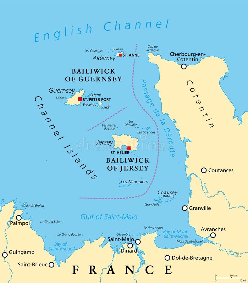
Free with trial Channel Islands, political map. The Crown Dependencies Bailiwick of Guernsey and Bailiwick of Jersey, an archipelago in the English Channel, off the coast of France. Remnants of the Duchy of Normandy. Mapping vectors Channel Islands, political map, Crown Dependencies Guernsey and Jersey. Channel Islands, political map. The Crown Dependencies Bailiwick of Guernsey and. Channel Islands, political map. The Crown Dependencies Bailiwick of Guernsey and Bailiwick of Jersey, an archipelago in the English Channel, off the coast of France. Remnants of the Duchy of Normandy.
Free with trial High detailed France physical map with labeling. Vector illustration. Mapping vectors High detailed France physical map with labeling. Vector illustration
Free with trial High detailed Hawaii physical map with labeling. Vector illustration. Mapping vectors High detailed Hawaii physical map with labeling. Vector illustration
Free with trial High detailed Austria physical map with labeling. clearly labeled, separated layers, vector illustration. Mapping vectors High detailed Austria physical map with labeling. Clearly labeled, separated layers, vector illustration
Free with trial Set of flat buttons for web site and mobile application. Ui Application (app). Mapping vectors Mobile application. Set of flat buttons for web site and mobile application. Ui Application (app. Set of flat buttons for web site and mobile application. Ui Application (app).
Free with trial Geographical vector map of the five natural areas of Namibia. Mapping vectors Geographical vector map of the five natural areas of Namibia.
Free with trial Administrative and political map of the Dutch city The Hague. Mapping vectors Administrative and political map of the Dutch city The Hague.
Free with trial Estonia road and National Park map. Mapping vectors Estonia road and National Park map.
Free with trial Overview map of the six historical districts of Venice, Italy. Mapping vectors Overview map of the six historical districts of Venice, Italy.
Free with trial Road map of czech region Stredocesky kraj Central Bohemian. Mapping vectors Road map of czech region Stredocesky kraj Central Bohemian.
Free with trial High detailed United States of America road map with labeling. Vector illustration. Mapping vectors High detailed United States of America road map with labeling. Vector illustration
Free with trial Saint Thomas,United States Virgin Islands,gray political map. One of the three largest islands of the USVI. The territorial capital and port of Charlotte Amalie is also located on the island. Vector. Mapping vectors Saint Thomas, United States Virgin Islands, gray political map. Saint Thomas,United States Virgin Islands,gray political map. One of the three largest islands of. Saint Thomas,United States Virgin Islands,gray political map. One of the three largest islands of the USVI. The territorial capital and port of Charlotte Amalie is also located on the island. Vector
Free with trial Old treasure map of Indian railway. Cartoon vector illustration. Mapping vectors Old treasure map of Indian railway. Cartoon vector illustration
Free with trial Silicon Valley, a region in Northern California, dark political map. Global center for high technology and innovation in the United States, located in the southern part of the San Francisco Bay Area. Mapping vectors Silicon Valley, a region in Northern California, USA, dark political map. Silicon Valley, a region in Northern California, dark political map. Global center for. Silicon Valley, a region in Northern California, dark political map. Global center for high technology and innovation in the United States, located in the southern part of the San Francisco Bay Area.
Free with trial Ile-de-France, departments and prefectures of the Paris Region, multi colored political map. Most populous region of France, centered on the capital Paris, located in the countries north-central part. Mapping vectors Ile-de-France, departments and prefectures of Paris Region, colored map. Ile-de-France, departments and prefectures of the Paris Region, multi colored political. Ile-de-France, departments and prefectures of the Paris Region, multi colored political map. Most populous region of France, centered on the capital Paris, located in the countries north-central part.
Free with trial Map of the Mexican holiday island of Holbox in the north of the Yucatan Peninsula, Mexico. Mapping vectors Map of the Mexican holiday island of Holbox in the north of the Yucatan Peninsula, Mexico.
Free with trial Street map of the city of darwin, Northern Territory, Australia. Mapping vectors Street map of the city of darwin, Northern Territory, Australia.
Free with trial Vector outline map of the Rocky Mountains in North America. Mapping vectors Vector outline map of the Rocky Mountains in North America.
Free with trial Vector map of the mascara islands la reunion and martinique. Mapping vectors Vector map of the mascara islands la reunion and martinique.
Free with trial Administrative vector map of the Canadian province of Québec. Mapping vectors Administrative vector map of the Canadian province of Québec.
 Sign in