Free with trial Political map of Africa in colors, easy to edit, copy, paste, move countries,. Mapping vectors Map of africa. Political map of Africa in colors, easy to edit, copy, paste, move countries. Political map of Africa in colors, easy to edit, copy, paste, move countries,
Free with trial Clinical Study Web Header Banner & Icon Set. Mapping vectors Clinical Study Web Header Banner & Icon Set. Clinical Study - Web Header Banner and Icon Set
Free with trial GPS services concept. Desktop computer, laptop, tablet and hand holding mobile phone with navigation application on the screen. Vector illustration. Mapping vectors GPS services concept. Desktop computer, laptop, tablet and hand holding mobile phone. With navigation application on the screen. Vector illustration
Free with trial Cartoon illustration of a man on top of the rock looking to the top of a mountain. Strategy, planning, forecast concept. Mapping vectors Man on top of the rock looking to the top of a mountain. Cartoon illustration of a man on top of the rock looking to the top of a mountain. Strategy, planning. Cartoon illustration of a man on top of the rock looking to the top of a mountain. Strategy, planning, forecast concept
Free with trial Alabama, U. S. state, gray political map with borders and county names. State in the Southeastern region of United States, subdivided into 67 counties. Nicknamed Yellowhammer State, and Heart of Dixie. Mapping vectors Alabama, U.S. state, subdivided into 67 counties, gray political map. Alabama, U.S. state, gray political map with borders and county names. State in the. Alabama, U.S. state, gray political map with borders and county names. State in the Southeastern region of United States, subdivided into 67 counties. Nicknamed Yellowhammer State, and Heart of Dixie.
Free with trial North Africa, political map with multi colored silhouettes of single countries. Sometimes called Northern Africa, a region encompassing the northern portion of the African continent. Illustration. Mapping vectors North Africa, political map with multi colored country silhouettes. North Africa, political map with multi colored silhouettes of single countries. Sometimes. North Africa, political map with multi colored silhouettes of single countries. Sometimes called Northern Africa, a region encompassing the northern portion of the African continent. Illustration.
Free with trial Social media elements illustration isolate on red background. Mapping vectors Social media elements illustration isolate on red background
Free with trial Topographic line map with river. Abstract horizontal banner. Aged paper effect. Mapping vectors Topographic line map with river. Abstract horizontal banner. Aged paper effect
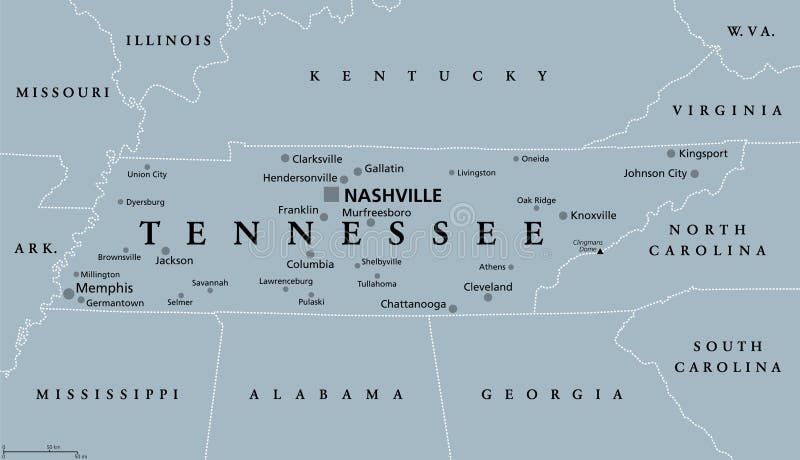
Free with trial Tennessee, TN, gray political map, with capital Nashville, and with large, important cities. State of Tennessee, located in the Southeastern region of the United States. Nicknamed The Volunteer State. Mapping vectors Tennessee, TN, gray political map, US state, The Volunteer State. Tennessee, TN, gray political map, with capital Nashville, and with large, important cities. Tennessee, TN, gray political map, with capital Nashville, and with large, important cities. State of Tennessee, located in the Southeastern region of the United States. Nicknamed The Volunteer State.
Free with trial Greece, the Hellenic Republic, gray political map. Country in Southeast Europe on southern tip of the Balkan peninsula, with capital Athens. Bordered by the Aegean, Ionian, and the Mediterranean Sea. Mapping vectors Greece, the Hellenic Republic, with capital Athens, gray political map. Greece, the Hellenic Republic, gray political map. Country in Southeast Europe on. Greece, the Hellenic Republic, gray political map. Country in Southeast Europe on southern tip of the Balkan peninsula, with capital Athens. Bordered by the Aegean, Ionian, and the Mediterranean Sea.
Free with trial Flat GPS navigation in the phone with a red and blue pointers. GPS tracking map. Track navigation pins on street maps, navigate mapping technology and locate position pin. Mapping vectors Flat GPS navigation in the phone with a red and blue pointers. GPS tracking map. Track navigation pins on street maps. Navigate mapping technology and locate
Free with trial Wireframe Landscape Pattern. Big Data. Geometric Terrain Design - Illustration Vector. Mapping vectors Wireframe Landscape Pattern. Big Data. Geometric Terrain Design. Illustration Vector
Free with trial Flat GPS navigation in the phone with a red and blue pointers. GPS tracking map. Track navigation pins on street maps, navigate mapping technology and locate position pin. Mapping vectors Flat GPS navigation in the phone with a red and blue pointers. GPS tracking map. Track navigation pins on street maps. Navigate mapping technology and locate
Free with trial City map Houston, monochrome detailed plan, vector illustration. For design travel illustration. Mapping vectors City map Houston, monochrome detailed plan, vector illustration. For design travel illustration
Free with trial Maps of Africa. Countries over white background. Mapping vectors Maps of Africa. Countries over white background
Free with trial Baltic Assembly BA member states political map. Regional organization in Europe promoting intergovernmental cooperation between Estonia, Latvia and Lithuania. English labeling. Illustration. Vector. Mapping vectors Baltic Assembly BA member states political map. Regional organization in Europe promoting intergovernmental cooperation between Estonia, Latvia and Lithuania
Free with trial Tokyo Major Metropolitan Area, political map of the Capital Region of Japan, located on the island Honshu. The map shows Itto Sanken, consisting of the prefectures Tokyo, Chiba, Saitama and Kanagawa. Mapping vectors Tokyo Major Metropolitan Area, Capital Region of Japan, political map. Tokyo Major Metropolitan Area, political map of the Capital Region of Japan, located on. Tokyo Major Metropolitan Area, political map of the Capital Region of Japan, located on the island Honshu. The map shows Itto Sanken, consisting of the prefectures Tokyo, Chiba, Saitama and Kanagawa.
Free with trial Liguria and the Italian Riviera, the Ligurian Riviera, political map. Region of north-western Italy, with capital Genoa. A narrow coastal strip between Ventimiglia and La Spezia, on the Ligurian Sea. Mapping vectors Liguria and the Italian Riviera, the Ligurian Riviera, political map. Region of north-western Italy, with capital Genoa. A narrow coastal strip between
Free with trial Chugoku Map. Map of Japan Prefecture. Vector illustration. Mapping vectors Chugoku Map. Map of Japan Prefecture. Vector illustration
Free with trial Map of the danube delta. In romania and ukraine. Mapping vectors Map of the danube delta. In romania and ukraine
Free with trial SWOT - Strengths Weaknesses Opportunities Threats. SWOT - Strengths Weaknesses Opportunities Threats business strategy mind map concept for presentations. Mapping vectors SWOT - Strengths Weaknesses Opportunities Threats. SWOT - Strengths Weaknesses Opportunities Threats business strategy mind map concept for presentations
Free with trial City map Las Vegas, monochrome detailed plan, vector illustration. For design travel illustration. Mapping vectors City map Las Vegas, monochrome detailed plan, vector illustration. For design travel illustration
Free with trial The major ocean gyres,world map. The most notable ocean gyres,flowing clockwise in the Northern and counterclockwise in the Southern hemisphere. Large systems of circulating ocean surface currents. Mapping vectors The major ocean gyres, world map of the most notable ocean gyres. The major ocean gyres,world map. The most notable ocean gyres,flowing clockwise in the Northern. The major ocean gyres,world map. The most notable ocean gyres,flowing clockwise in the Northern and counterclockwise in the Southern hemisphere. Large systems of circulating ocean surface currents.
Free with trial Isometric thin line design concept data analysis. Illustartion of isometric thin line design concept data analysis. Mapping vectors Isometric thin line design concept data analysis. Illustartion of isometric thin line design concept data analysis
Free with trial Eastern Ukraine political map. The Crimea, a peninsula on the coast of Black Sea, and the Donbass, formed by Donetsk and Luhansk region, disputed areas between Ukraine and Russia. Illustration. Vector. Mapping vectors Eastern Ukraine, Crimea and Donbass, political map. Eastern Ukraine political map. The Crimea, a peninsula on the coast of Black Sea, and the Donbass, formed by. Eastern Ukraine political map. The Crimea, a peninsula on the coast of Black Sea, and the Donbass, formed by Donetsk and Luhansk region, disputed areas between Ukraine and Russia. Illustration. Vector
Free with trial United States Map Horizontal Stripes Logo Design. Concept for an American Style of Life. Mapping vectors United States Map Horizontal Stripes Logo Design. Concept for an American Style of Life
Free with trial Europe Political Map. Retro Colors and Bathymetry. Detailed illustration of Europe Map. Mapping vectors Europe Political Map. Retro Colors and Bathymetry. Detailed illustration of Europe Map
Free with trial Crimea political map. Peninsula in Eastern Europe on the northern coast of the Black Sea, with disputed status. Controlled and governed by Russia, internationally recognized as part of Ukraine. Vector. Mapping vectors Crimea, peninsula in Eastern Europe, political map. Crimea political map. Peninsula in Eastern Europe on the northern coast of the Black Sea, with disputed. Crimea political map. Peninsula in Eastern Europe on the northern coast of the Black Sea, with disputed status. Controlled and governed by Russia, internationally recognized as part of Ukraine. Vector
Free with trial Highly detailed political map of Africa isolated on white and fl. At map pointers with separated layers. Mapping vectors Highly detailed political map of Africa isolated on white and fl. At map pointers with separated layers
Free with trial Sri Lanka and part of Southern India, political map. Democratic Socialist Republic of Sri Lanka, formerly known as Ceylon, island country in South Asia and Indian Ocean, with de facto capital Colombo. Mapping vectors Sri Lanka and part of Southern India, political map. Democratic Socialist Republic of Sri Lanka, formerly known as Ceylon, island country in South Asia and
Free with trial Hurricane free Caribbean islands, gray political map. Leeward Antilles and Windward Islands are safest from hurricanes. Aruba, Barbados, Bonaire, Curacao, Grenada, The Grenadines, Trinidad and Tobago. Mapping vectors Hurricane free Caribbean islands, gray map of Leeward Antilles and Windward Islands. Hurricane free Caribbean islands, gray political map. Leeward Antilles and. Hurricane free Caribbean islands, gray political map. Leeward Antilles and Windward Islands are safest from hurricanes. Aruba, Barbados, Bonaire, Curacao, Grenada, The Grenadines, Trinidad and Tobago.
Free with trial USA political map. Color vector map with state borders. Isolated on a white background. Mapping vectors USA political map. Color vector map with state borders. Isolated on a white background
Free with trial Set of travel posters with Boston, detailed urban street plan city map, Silhouette city skyline, vector artwork, collection of wall tourist decorations. Mapping vectors Set of travel posters with Boston, detailed urban street plan city map, Silhouette city skyline, vector artwork. Collection of wall tourist decorations
Free with trial High detailed Asia physical map with rivers and surface elements. Vector illustration. Mapping vectors High detailed Asia physical map. High detailed Asia physical map with rivers and surface elements. Vector illustration. High detailed Asia physical map with rivers and surface elements. Vector illustration.
Free with trial Austria Map and Austria location on Europe Map. Isolated on transparent background. Highly detailed vector illustration of map. Mapping vectors Austria Map and Austria location on Europe Map. Isolated on transparent background. Highly detailed vector illustration of map
Free with trial Stereographic world map projectio. N. Black and white world map vector illustration. Mapping vectors Stereographic world map projectio. N. Black and white world map vector illustration
Free with trial Smartphone with mobile gps navigation system and map with pins. Vector app game concept. Location seach positioning illustration. Mapping vectors Smartphone with mobile gps navigation system and map pins. Vector app game concept. Smartphone with mobile gps navigation system and map with pins. Vector app. Smartphone with mobile gps navigation system and map with pins. Vector app game concept. Location seach positioning illustration
Free with trial Brain polygon glowing in business social network icons infographic science digital futuristic abstract background vector. Illustration. Mapping vectors Brain polygon glowing in business social network icons infographic science digital futuristic abstract background vector. Illustration
Free with trial Quebec City Windsor Corridor,political map. Most densely populated and heavily industrialized region of Canada. The region extends between Quebec City in the northeast and Windsor,Ontario. Vector. Mapping vectors Quebec City Windsor Corridor, region in Canada, political map. Quebec City Windsor Corridor,political map. Most densely populated and heavily industrialized. Quebec City Windsor Corridor,political map. Most densely populated and heavily industrialized region of Canada. The region extends between Quebec City in the northeast and Windsor,Ontario. Vector.
Free with trial Europe Political Map. Vintage Colors and Bathymetry. Detailed illustration of Europe Map. Mapping vectors Europe Political Map. Vintage Colors and Bathymetry. Detailed illustration of Europe Map
Free with trial The Maritimes region of Eastern Canada, also called Maritime provinces, gray political map, with capitals, borders and large cities. The provinces New Brunswick, Nova Scotia, and Prince Edward Island. Mapping vectors The Maritimes region of Eastern Canada, Maritime provinces gray political map. The Maritimes region of Eastern Canada, also called Maritime provinces, gray. The Maritimes region of Eastern Canada, also called Maritime provinces, gray political map, with capitals, borders and large cities. The provinces New Brunswick, Nova Scotia, and Prince Edward Island.
Free with trial Czech Republic Physical Map White and Grey. No text - Detailed map of Czech Republic vector illustration - All elements are separated in editable layers clearly labeled. Mapping vectors Czech Republic Physical Map White and Grey. No text. Detailed map of Czech Republic vector illustration - All elements are separated in editable layers
Free with trial Alternative version of tree, bushes, and small vegetation set for tropical rainforest scene on oblique projection. Images are designed to align into square grid for easy game tile-mapping. Mapping vectors Tropical Rainforest Plants Set Alternative Version. Alternative version of tree, bushes, and small vegetation set for tropical rainforest scene on oblique. Alternative version of tree, bushes, and small vegetation set for tropical rainforest scene on oblique projection. Images are designed to align into square grid for easy game tile-mapping.
Free with trial Set of travel posters with Chicago, detailed urban street plan city map, Silhouette city skyline, vector artwork, collection of wall tourist decorations. Mapping vectors Set of travel posters with Chicago, detailed urban street plan city map, Silhouette city skyline, vector artwork. Collection of wall tourist decorations
Free with trial AI-Driven Drone Operations abstract concept vector illustration set. Drones deliver packages, inspect structures, and monitor traffic with GPS, sensors, and live video. abstract metaphor. Mapping vectors AI-Driven Drone Operations abstract concept vector illustrations. AI-Driven Drone Operations abstract concept vector illustration set. Drones deliver packages. AI-Driven Drone Operations abstract concept vector illustration set. Drones deliver packages, inspect structures, and monitor traffic with GPS, sensors, and live video. abstract metaphor.
Free with trial Albers equal area conic projection. Black and white world map with countries and borders. Earth plannar map. Mapping vectors Albers equal area conic projection. Black and white world map with countries and borders. Earth plannar map
Free with trial Travel poster, urban street plan city map Phoenix and Las Vegas, vector illustration. For design map of roads, rivers and paths. Mapping vectors Travel poster, urban street plan city map Phoenix and Las Vegas, vector illustration. For design map of roads, rivers and paths
Free with trial Set of travel posters with Singapore, detailed urban street plan city map, Silhouette city skyline, vector artwork, collection of wall tourist decorations. Mapping vectors Set of travel posters with Singapore, detailed urban street plan city map, Silhouette city skyline, vector artwork. Collection of wall tourist decorations
Free with trial Florida state counties, political map. Florida, a state in the Southeastern region of the United States, subdivided into 67 counties. Map with boundaries and county names. Illustration. Vector. Mapping vectors U.S. state of Florida, subdivided into 67 counties, political map. Florida state counties, political map. Florida, a state in the Southeastern region of the. Florida state counties, political map. Florida, a state in the Southeastern region of the United States, subdivided into 67 counties. Map with boundaries and county names. Illustration. Vector
Free with trial NEOM political map of the 500 billion dollar megacity project in Saudi Arabia along the Red Sea coast. Location of the smart and tourist city with autonomous judicial system. English labeling. Vector. Mapping vectors NEOM, megacity project in Saudi Arabia, political map. NEOM political map of the 500 billion dollar megacity project in Saudi Arabia along the Red Sea coast. NEOM political map of the 500 billion dollar megacity project in Saudi Arabia along the Red Sea coast. Location of the smart and tourist city with autonomous judicial system. English labeling. Vector.
Free with trial Czech Republic Administrative Map Isolated on White - Detailed map of Czech Republic vector illustration - All elements are separated in editable layers clearly labeled. Mapping vectors Czech Republic Administrative Map Isolated on White. Detailed map of Czech Republic vector illustration - All elements are separated in editable layers
Free with trial Lesser Antilles of the Caribbean, multicolored political map. Group of islands between Greater Antilles and South America. Divided into the Leeward Islands, Windward Islands, and the Leeward Antilles. Mapping vectors Lesser Antilles of the Caribbean, multicolored political map. Group of islands between Greater Antilles and South America. Divided into the Leeward Islands
Free with trial Northeast, U. S. census region, multi colored political map. Census region 1 of the United States, consisting of 9 single states. Colored silhouettes of single states with borders and their capitals. Mapping vectors Northeast, U.S. census region, multi colored political map. Census region 1 of the United States, consisting of 9 single states. Colored silhouettes of single
Free with trial Road Map for GPS Application. Easy to edit vector illustration of road map for GPS application. Mapping vectors Road Map for GPS Application. Easy to edit vector illustration of road map for GPS application
Free with trial North America Physical Map Isolated on White. No text. Vector illustration. Mapping vectors North America Physical Map Isolated on White. No text. Vector illustration
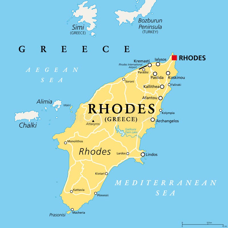
Free with trial Rhodes, Greek island, political map. Largest of Dodecanese islands of Greece, in Mediterranean Sea, with several nicknames, such as Island of the Sun, The Pearl Island, and The Island of the Knights. Mapping vectors Rhodes, political map, largest of the Dodecanese island of Greece. Rhodes, Greek island, political map. Largest of Dodecanese islands of Greece, in Mediterranean. Rhodes, Greek island, political map. Largest of Dodecanese islands of Greece, in Mediterranean Sea, with several nicknames, such as Island of the Sun, The Pearl Island, and The Island of the Knights.
Free with trial Set of colorful map pointer icons. GPS location symbol. Vector illustration web design element. Mapping vectors Set of colorful map pointer icons. GPS location symbol. Vector illustration web design element
Free with trial USA Political Map and flat map pointers isolated on white with water objects and cities. Mapping vectors USA Political Map and flat map pointers isolated on white. With water objects and cities
Free with trial Bali political map, with capital Denpasar. A province and island of Indonesia, westernmost of Lesser Sunda Islands, east of Java, west of Lombok. The only Hindu-majority province in Indonesia. Vector. Mapping vectors Bali, political map, a province and island of Indonesia. Bali political map, with capital Denpasar. A province and island of Indonesia, westernmost of Lesser. Bali political map, with capital Denpasar. A province and island of Indonesia, westernmost of Lesser Sunda Islands, east of Java, west of Lombok. The only Hindu-majority province in Indonesia. Vector.
Free with trial East North Central states, multi colored political map with borders. United States Census division of the Midwest region, consisting of the states Illinois, Indiana, Michigan, Ohio, and Wisconsin. Mapping vectors East North Central states in the Midwest region of USA, colored political map. East North Central states, multi colored political map with borders. United States. East North Central states, multi colored political map with borders. United States Census division of the Midwest region, consisting of the states Illinois, Indiana, Michigan, Ohio, and Wisconsin.
Free with trial Washington, D. C. , political map. District of Columbia, capital city and federal district of the United States. Located on the Potomac River, across from Virginia, sharing land borders with Maryland. Mapping vectors Washington, District of Columbia, capital of USA, political map. Washington, D.C., political map. District of Columbia, capital city and federal district of the. Washington, D.C., political map. District of Columbia, capital city and federal district of the United States. Located on the Potomac River, across from Virginia, sharing land borders with Maryland.
Free with trial Black and white heart-shaped planet vector illustration. Bonne pseudoconical equal area world map projection. Heart shape world map. Mapping vectors Heart shape world map. Black and white heart-shaped planet vector illustration. Bonne pseudoconical equal area world map projection. Heart shape world map. Black and white heart-shaped planet vector illustration. Bonne pseudoconical equal area world map projection. Heart shape world map.
Free with trial High detailed France physical map. Vector illustration. Mapping vectors High detailed France physical map. Vector illustration
Free with trial Vector, set of mind map graphic elements 2 to 5 made from 3d white center circles with arrows leading to space for text on a subtle gradient background made in illustrator. Mapping vectors Mind Map Arrows 2, 3, 4, 5 Infographic Vector Set. Vector, set of mind map graphic elements 2 to 5 made from 3d white center circles with arrows leading to space. Vector, set of mind map graphic elements 2 to 5 made from 3d white center circles with arrows leading to space for text on a subtle gradient background made in illustrator
Free with trial Bosphorus and Dardanelles, gray political map. The Turkish Straits, internationally significant, narrow waterways in Turkey. Passages, connecting the Aegean Sea and Sea of Marmara with the Black Sea. Mapping vectors Bosporus and Dardanelles, the Turkish Straits, gray political map. Bosphorus and Dardanelles, gray political map. The Turkish Straits, internationally. Bosphorus and Dardanelles, gray political map. The Turkish Straits, internationally significant, narrow waterways in Turkey. Passages, connecting the Aegean Sea and Sea of Marmara with the Black Sea.
Free with trial Regions of Iceland, political map, with capital Reykjavik. Eight regions and their seats, used for statistical purposes. Nordic island country in Atlantic Ocean. English labeling. Illustration. Vector. Mapping vectors Regions of Iceland, Nordic island country, political map. Regions of Iceland, political map, with capital Reykjavik. Eight regions and their seats, used for. Regions of Iceland, political map, with capital Reykjavik. Eight regions and their seats, used for statistical purposes. Nordic island country in Atlantic Ocean. English labeling. Illustration. Vector
Free with trial Pacific states, the West Coast of the United States, gray political map. United States Census division of the West region, consisting of the states Alaska, California, Hawaii, Oregon, and Washington. Mapping vectors Pacific states, the West Coast of the United States, gray political map. United States Census division of the West region, consisting of the states Alaska
Free with trial Genomic visualization. Dna genomes sequencing data analysis. Digital internet technology, bioinformatics testing chromosome vector visual texture sequence concept. Mapping vectors Genomic visualization. Dna genomes sequencing data analysis. Digital internet technology, bioinformatics testing. Chromosome vector visual texture sequence
Free with trial Benelux single states political map. Region formed by the countries Belgium, Netherlands and Luxembourg. The name Benelux comes from the first letters of the countries. Illustration over white. Vector. Mapping vectors Benelux, Belgium, Netherlands and Luxembourg, single states, political map. Benelux single states political map. Region formed by the countries Belgium. Benelux single states political map. Region formed by the countries Belgium, Netherlands and Luxembourg. The name Benelux comes from the first letters of the countries. Illustration over white. Vector
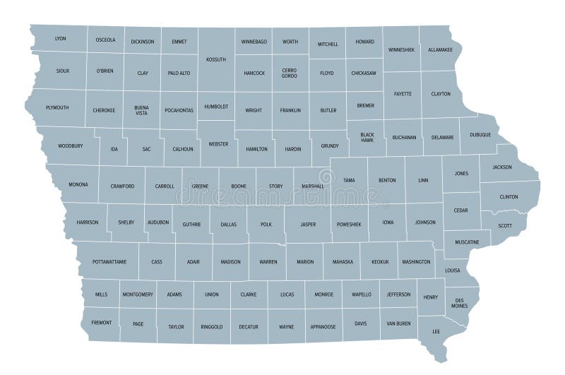
Free with trial Iowa counties, gray political map with borders and county names. Landlocked state in the Midwestern region of the United States, subdivided into 99 counties. Nicknamed The Hawkeye State. Illustration. Mapping vectors Iowa, U.S. state subdivided into 99 counties, gray political map. Iowa counties, gray political map with borders and county names. Landlocked state in the. Iowa counties, gray political map with borders and county names. Landlocked state in the Midwestern region of the United States, subdivided into 99 counties. Nicknamed The Hawkeye State. Illustration
Free with trial Scientific Process Icon Set with Web Header Banner. Mapping vectors Scientific Process Icon Set with Web Header Banner. Scientific Process Icon Set & Web Header Banner
Free with trial Indiana, IN, political map, with the capital Indianapolis, and most important cities, rivers and lakes. State in the Midwestern region of the United States of America, nicknamed The Hoosier State. Mapping vectors Indiana, IN, political map, US state, nicknamed The Hoosier State. Indiana, IN, political map, with the capital Indianapolis, and most important cities, rivers. Indiana, IN, political map, with the capital Indianapolis, and most important cities, rivers and lakes. State in the Midwestern region of the United States of America, nicknamed The Hoosier State.
Free with trial This image showcases an advanced drone equipped with a high-resolution camera. The drone features four extended arms, each with rotors, and a centrally mounted camera on a gimbal for stabilized footage. The sleek gray design and robust build suggest it is designed for professional use, such as aerial photography or videography. The drone's sophisticated engineering and advanced technology make it. Mapping vectors Advanced drone with high-resolution camera. This image showcases an advanced drone equipped with a high-resolution camera. The drone features four extended arms. This image showcases an advanced drone equipped with a high-resolution camera. The drone features four extended arms, each with rotors, and a centrally mounted camera on a gimbal for stabilized footage. The sleek gray design and robust build suggest it is designed for professional use, such as aerial photography or videography. The drone's sophisticated engineering and advanced technology make it
Free with trial Circle on cycle template. Can use for brochure and business project background. Mapping vectors Circle on cycle template. Can use for brochure and business project background
Free with trial NEOM and Sinai Peninsula,gray political map. Neom,a planned smart city in Tabuk Province in northwestern Saudi Arabia,north the Red Sea,east of Egypt,across the Gulf of Aqaba and south of Jordan. Mapping vectors NEOM and Sinai Peninsula, a smart city project, gray political map. NEOM and Sinai Peninsula,gray political map. Neom,a planned smart city in Tabuk Province in. NEOM and Sinai Peninsula,gray political map. Neom,a planned smart city in Tabuk Province in northwestern Saudi Arabia,north the Red Sea,east of Egypt,across the Gulf of Aqaba and south of Jordan.
Free with trial Subregions of Oceania, political map. Geoscheme with regions in the Pacific Ocean and next to Asia. Melanesia, Micronesia, Polynesia, and Australasia, short for Australia and New Zealand. Vector. Mapping vectors Subregions of Oceania, geoscheme with regions in the Pacific, political map. Subregions of Oceania, political map. Geoscheme with regions in the Pacific Ocean. Subregions of Oceania, political map. Geoscheme with regions in the Pacific Ocean and next to Asia. Melanesia, Micronesia, Polynesia, and Australasia, short for Australia and New Zealand. Vector.
Free with trial New Caledonia political map, capital Noumea. Collectivity of France in Pacific Ocean. Archipelago. Main Island Grand Terre and Loyalty Islands. English labeling. Gray illustration over white. Vector. Mapping vectors New Caledonia political map gray. New Caledonia political map, capital Noumea. Collectivity of France in Pacific Ocean. Archipelago. Main Island Grand Terre and. New Caledonia political map, capital Noumea. Collectivity of France in Pacific Ocean. Archipelago. Main Island Grand Terre and Loyalty Islands. English labeling. Gray illustration over white. Vector.
Free with trial Scientific Process Icon Set with Web Header Banner. Mapping vectors Scientific Process Icon Set with Web Header Banner. Scientific Process Icon Set & Web Header Banner
Free with trial Scandinavia, political map. A subregion in Northern Europe, most commonly referring to Denmark, Norway, and Sweden, and more broadly also with Aland, Faroe Islands, Finland and Iceland. Illustration. Mapping vectors Scandinavia, a subregion in Northern Europe, political map. Scandinavia, political map. A subregion in Northern Europe, most commonly referring to Denmark. Scandinavia, political map. A subregion in Northern Europe, most commonly referring to Denmark, Norway, and Sweden, and more broadly also with Aland, Faroe Islands, Finland and Iceland. Illustration.
 Sign in