Free with trial Prague city map. Map of the historical center of Prague. Mapping vectors Prague city map. Map of the historical center of Prague
Free with trial Ancestry or Genealogy Icon with Family Tree Album Web Header Banner & Icon Set. Mapping vectors Ancestry or Genealogy Icon with Family Tree Album Web Header Banner & Icon Set. Ancestry / Genealogy Icon with Family Tree Album Web Header Banner and Icon Set
Free with trial Sun path diagram for architectural planning, showing solar movement and orientation for daylight strategy and energy-efficient design. Mapping vectors Sun path diagram for architectural planning,. Showing solar movement and orientation for daylight strategy and energy-efficient design
Free with trial Railway and Station Building Construction Kit with Train - Build your own railway, grouped and layered, see my portfolio for other kits. Mapping vectors Railway and Station Building Construction Kit with Train. Build your own railway, grouped and layered, see my portfolio for other kits
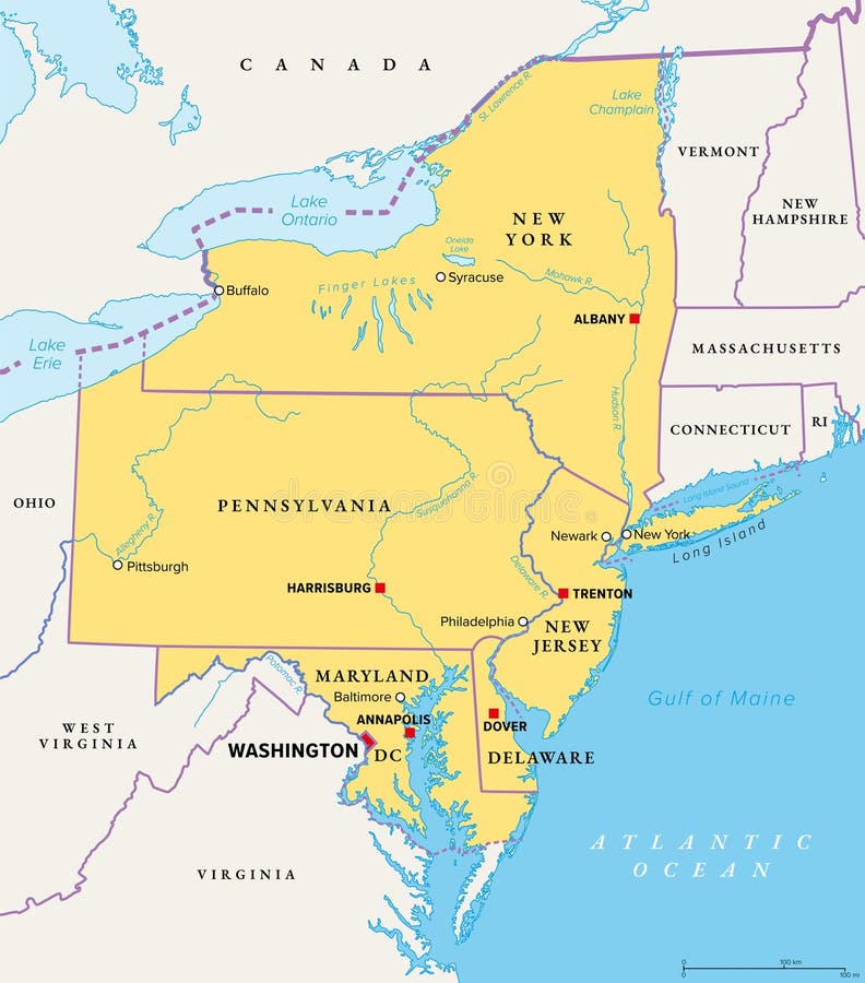
Free with trial Mid-Atlantic region of the United States, political map. Located in the overlap between Northeastern and Southeastern states, including Delaware, D. C. , Maryland, New Jersey, New York and Pennsylvania. Mapping vectors Mid-Atlantic region of the United States, political map. Located in the overlap between Northeastern and Southeastern states, including Delaware, D.C
Free with trial Washington, D. C. , gray political map. District of Columbia, capital city and federal district of the United States. Located on Potomac River, across from Virginia, sharing land borders with Maryland. Mapping vectors Washington, District of Columbia, capital of USA, gray political map. Washington, D.C., gray political map. District of Columbia, capital city and federal. Washington, D.C., gray political map. District of Columbia, capital city and federal district of the United States. Located on Potomac River, across from Virginia, sharing land borders with Maryland.
Free with trial Map of the Magdalena River Drainage Basin, Colombia. Mapping vectors Map of the Magdalena River Drainage Basin, Colombia.
Free with trial Abstract artistic background with curled pattern. Vector vintage illustration of curled vortex stripes. Marble or acrylic texture imitation. Abstract diffusion psychedelic background. Mapping vectors Abstract artistic curl background. Abstract artistic background with curled pattern. Vector vintage illustration of curled vortex stripes. Marble or acrylic. Abstract artistic background with curled pattern. Vector vintage illustration of curled vortex stripes. Marble or acrylic texture imitation. Abstract diffusion psychedelic background
Free with trial California Physical Map White and Grey Isolated On White - No text - Highly Detailed Relief Map of California State vector illustration - All elements are separated in editable layers clearly labeled. Mapping vectors California Physical Map White and Grey Isolated On White - No text. Highly Detailed Relief Map of California State vector illustration - All elements are. California Physical Map White and Grey Isolated On White - No text - Highly Detailed Relief Map of California State vector illustration - All elements are separated in editable layers clearly labeled
Free with trial Bali, gray political map. A province and island of Indonesia, the westernmost of Lesser Sunda Islands, east of Java, west of Lombok. The only Hindu-majority province in Indonesia. Illustration. Vector. Mapping vectors Bali, gray political map, a province and island of Indonesia. Bali, gray political map. A province and island of Indonesia, the westernmost of Lesser Sunda. Bali, gray political map. A province and island of Indonesia, the westernmost of Lesser Sunda Islands, east of Java, west of Lombok. The only Hindu-majority province in Indonesia. Illustration. Vector
Free with trial Map of melbourne with Shrine of Remembrance, Captain Cooks Cottage, Eureka tower, Royal zoo gardens, star or ferris wheel, Port Phillip Bay, Dandenong park, Rippon Lea Estate. City tourism, landmark. Mapping vectors Melbourne,Australia map with landmarks,sightseeing. Map of melbourne with Shrine of Remembrance, Captain Cooks Cottage, Eureka tower, Royal zoo gardens, star or. Map of melbourne with Shrine of Remembrance, Captain Cooks Cottage, Eureka tower, Royal zoo gardens, star or ferris wheel, Port Phillip Bay, Dandenong park, Rippon Lea Estate. City tourism, landmark
Free with trial Travel poster, urban street plan city map Taipei and Hong Kong, vector illustration, collection of wall tourist decorations. Mapping vectors Travel poster, urban street plan city map Taipei and Hong Kong, vector illustration. Collection of wall tourist decorations
Free with trial Crete, Greek island, gray political map, with capital Heraklion. Largest island of Greece and fifth largest in the Mediterranean Sea. With major Minoan settlements Knossos, Phaistos, Malia and Zakros. Mapping vectors Crete, Greek island, gray political map, with capital Heraklion. Largest island of Greece and fifth largest in the Mediterranean Sea. With major Minoan
Free with trial Map of the Gulf Stream with its northern extension North Atlantic Drift. Warm and swift Atlantic Ocean current, originates in Gulf of Mexico, flows through Straits of Florida and up the US coastline. Mapping vectors Map of the Gulf Stream with its northern extension North Atlantic Drift. Warm and swift Atlantic Ocean current, originates in Gulf of Mexico, flows through
Free with trial Bitmap picture with additional vector file. RGB file. Mapping vectors Pins for map. Bitmap picture with additional vector file. RGB file. Bitmap picture with additional vector file. RGB file.
Free with trial Utah, U. S. state, subdivided into 29 counties, multi colored political map with capital Salt Lake City, borders and county names. State in the Mountain West region of Western USA. The Beehive State. Mapping vectors Utah, U.S. state, subdivided into 29 counties, multi colored map. Utah, U.S. state, subdivided into 29 counties, multi colored political map with capital Salt. Utah, U.S. state, subdivided into 29 counties, multi colored political map with capital Salt Lake City, borders and county names. State in the Mountain West region of Western USA. The Beehive State.
Free with trial Lanzarote, political map, with capital Arrecife. Northernmost and easternmost island of Canary Islands, an archipelago and autonomous community of Spain, in the Atlantic Ocean off the coast of Africa. Mapping vectors Lanzarote island, political map, part of Canary Islands, Spain. Lanzarote, political map, with capital Arrecife. Northernmost and easternmost island of Canary. Lanzarote, political map, with capital Arrecife. Northernmost and easternmost island of Canary Islands, an archipelago and autonomous community of Spain, in the Atlantic Ocean off the coast of Africa.
Free with trial Balearic Islands, gray political map, with the main islands Mallorca, Ibiza, Menorca and Formentera. Archipelago of islands in Spain in Mediterranean Sea, near Iberian Peninsula. Illustration. Vector. Mapping vectors Balearic Islands, gray map, Mallorca, Ibiza, Menorca, Formentera. Balearic Islands, gray political map, with the main islands Mallorca, Ibiza, Menorca and. Balearic Islands, gray political map, with the main islands Mallorca, Ibiza, Menorca and Formentera. Archipelago of islands in Spain in Mediterranean Sea, near Iberian Peninsula. Illustration. Vector.
Free with trial Mykonos, an island of Greece, political map. Greek island in the Aegean Sea, and part of the Cyclades. Nicknamed The Island of the Winds, known as a gay-friendly destination with a vibrant nightlife. Mapping vectors Mykonos, Greek island and part of the Cyclades, political map. Mykonos, an island of Greece, political map. Greek island in the Aegean Sea, and part of the. Mykonos, an island of Greece, political map. Greek island in the Aegean Sea, and part of the Cyclades. Nicknamed The Island of the Winds, known as a gay-friendly destination with a vibrant nightlife.
Free with trial Outline icons set representing data transformation with symbols for flowing data, systematic process, data enhancement, fundamental change, and data refinement, preferably at the end of the sentence. Mapping vectors Outline icons set representing data transformation with symbols for flowing... Outline icons set representing data transformation with symbols for flowing data. Outline icons set representing data transformation with symbols for flowing data, systematic process, data enhancement, fundamental change, and data refinement, preferably at the end of the sentence.
Free with trial Bay of Bengal, gray political map. Northeastern part of Indian Ocean and largest bay of the world, positioned between the Indian subcontinent and Indochinese peninsula, located below Bengal region. Mapping vectors Bay of Bengal, northeastern part of Indian Ocean, gray political map. Bay of Bengal, gray political map. Northeastern part of Indian Ocean and largest bay of the. Bay of Bengal, gray political map. Northeastern part of Indian Ocean and largest bay of the world, positioned between the Indian subcontinent and Indochinese peninsula, located below Bengal region.
Free with trial City map Indianapolis, monochrome detailed plan, vector illustration, wall art tourist decorations. Mapping vectors City map Indianapolis, monochrome detailed plan, vector illustration. Wall art tourist decorations
Free with trial South west england. Administrative map eps 10. Mapping vectors South west england. Administrative map eps 10
Free with trial Travel poster, urban street plan city map Atlanta and New Orleans, vector illustration. For design. Mapping vectors Travel poster, urban street plan city map Atlanta and New Orleans, vector illustration. For design
Free with trial San Francisco Bay Area, a region of the U. S. state California, political map with counties and largest cities. An area that surrounds and include the San Francisco Bay, which is a large tidal estuary. Mapping vectors San Francisco Bay Area, region of the U.S. state California, political map. San Francisco Bay Area, a region of the U.S. state California, political map with. San Francisco Bay Area, a region of the U.S. state California, political map with counties and largest cities. An area that surrounds and include the San Francisco Bay, which is a large tidal estuary.
Free with trial Canada Map on transparent background. Detailed vector illustration. Mapping vectors Canada Map on transparent background. Detailed vector illustration
Free with trial Texas icons on silver and gold arrow banners. Silver and gold arrows on black checkered tabs with texas icons. Mapping vectors Texas icons on silver and gold arrow banners. Silver and gold arrows on black checkered tabs with texas icons
Free with trial Montana, U. S. state, multi colored political map with borders, county names and Capital Helena. State in the Mountain West region of the United States, subdivided into 56 counties. Big Sky Country. Mapping vectors Montana, U.S. state, subdivided into 56 counties, multi colored map. Montana, U.S. state, multi colored political map with borders, county names and Capital. Montana, U.S. state, multi colored political map with borders, county names and Capital Helena. State in the Mountain West region of the United States, subdivided into 56 counties. Big Sky Country
Free with trial Illinois, IL, political map, with capital Springfield and metropolitan area Chicago. State in the Midwestern region of United States, nicknamed Land of Lincoln, Prairie State, and Inland Empire State. Mapping vectors Illinois, IL, political map, US state, nicknamed Land of Lincoln. Illinois, IL, political map, with capital Springfield and metropolitan area Chicago. State in. Illinois, IL, political map, with capital Springfield and metropolitan area Chicago. State in the Midwestern region of United States, nicknamed Land of Lincoln, Prairie State, and Inland Empire State.
Free with trial Mississippi, MS, political map, with capital Jackson, important cities, rivers and lakes. State in the Southeastern region of the United States, nicknamed The Magnolia State and The Hospitality State. Mapping vectors Mississippi, MS, political map, US state, nicknamed The Magnolia State. Mississippi, MS, political map, with capital Jackson, important cities, rivers and lakes. Mississippi, MS, political map, with capital Jackson, important cities, rivers and lakes. State in the Southeastern region of the United States, nicknamed The Magnolia State and The Hospitality State.
Free with trial Maine, ME, gray political map with capital Augusta. Northernmost state in the United States of America, and located in the New England region. The Pine Tree State. Vacationland. Illustration. Vector. Mapping vectors Maine, ME, gray political map, The Pine Tree State, Vacationland. Maine, ME, gray political map with capital Augusta. Northernmost state in the United States of. Maine, ME, gray political map with capital Augusta. Northernmost state in the United States of America, and located in the New England region. The Pine Tree State. Vacationland. Illustration. Vector.
Free with trial Marketing Line Icons Set. Content,Search,Strategies,Marketing,Ecommerce,Branding,Seo,Electronic Devices,Reports,Analysis,Social and more Vector Line icons Collection. Mapping vectors Marketing Line Icons Set. Content, Search, Strategies, Marketing, Ecommerce... Marketing Line Icons Set. Content,Search,Strategies,Marketing,Ecommerce,Branding. Marketing Line Icons Set. Content,Search,Strategies,Marketing,Ecommerce,Branding,Seo,Electronic Devices,Reports,Analysis,Social and more Vector Line icons Collection
Free with trial Ukraine maps set. Set of Ukrainian map with names of oblast and blank map of Ukraine. Vector. Illustration. Mapping vectors Ukraine maps set. Set of Ukrainian map with names of oblast and blank map of Ukraine. Vector. Illustration
Free with trial Scientific Process Icon Set with hypothesis, analysis, etc. Mapping vectors Scientific Process Icon Set with hypothesis, analysis, etc. Scientific Process Icon Set - hypothesis, analysis, etc
Free with trial Genomic data. Dna test infographic, molecule structure genetic sequencing chart and chromosome architecture genealogy. Diagram, vector science analytics concept. Mapping vectors Genomic data. Dna test infographic, molecule structure genetic sequencing chart and chromosome architecture genealogy. Diagram, vector science analytics concept
Free with trial Road map of the Republic of San Marino. Mapping vectors Road map of the Republic of San Marino.
Free with trial City map Phoenix, monochrome detailed plan, vector illustration. For design travel illustration. Mapping vectors City map Phoenix, monochrome detailed plan, vector illustration. For design travel illustration
Free with trial Australia, political map, with the capital Canberra, administrative states and territories. The Commonwealth of Australia, a sovereign country and continent. Illustration on white background. Vector. Mapping vectors Australia, administrative states and territories, political map. Australia, political map, with the capital Canberra, administrative states and territories. The. Australia, political map, with the capital Canberra, administrative states and territories. The Commonwealth of Australia, a sovereign country and continent. Illustration on white background. Vector.
Free with trial Ukraine map. Ukrainian map with names of oblast. Cartography of Ukraine. Vector. Illustration. Mapping vectors Ukraine map. Ukrainian map with names of oblast. Cartography of Ukraine. Vector. Illustration
Free with trial Kentucky, U. S. state subdivided into 120 counties, gray political map with borders and county names. Commonwealth of Kentucky, a state in the Southeastern Region of USA, nicknamed The Bluegrass State. Mapping vectors Kentucky, U.S. state subdivided into 120 counties, gray political map. With borders and county names. Commonwealth of Kentucky, a state in the Southeastern. Kentucky, U.S. state subdivided into 120 counties, gray political map with borders and county names. Commonwealth of Kentucky, a state in the Southeastern Region of USA, nicknamed The Bluegrass State.
Free with trial Menorca, or Minorca, political map, with capital Mahon or Port Mahon, official Mao. Island of the autonomous community of the Balearic Islands, located in the Mediterranean Sea, and part of Spain. Mapping vectors Menorca, or Minorca, political map, with the capital Mahon. Menorca, or Minorca, political map, with capital Mahon or Port Mahon, official Mao. Island of the. Menorca, or Minorca, political map, with capital Mahon or Port Mahon, official Mao. Island of the autonomous community of the Balearic Islands, located in the Mediterranean Sea, and part of Spain.
Free with trial Benelux, Benelux Union member states, political map. Politico-economic union and formal international intergovernmental cooperation of the European states Belgium, the Netherlands, and Luxembourg. Mapping vectors Benelux Union member states, Belgium, Netherlands, Luxembourg, political map. Benelux, Benelux Union member states, political map. Politico-economic union and. Benelux, Benelux Union member states, political map. Politico-economic union and formal international intergovernmental cooperation of the European states Belgium, the Netherlands, and Luxembourg.
Free with trial Borneo, divided among Malaysia, Brunei and Indonesia, gray political map. Third-largest island in the world, and one of the Greater Sunda Islands, in the geographic centre of Maritime Southeast Asia. Mapping vectors Borneo, divided among Malaysia, Brunei and Indonesia, gray political map. Third-largest island in the world, and one of the Greater Sunda Islands, in the
Free with trial Global network connection. World map point and line composition. Concept of global business. Vector Illustration. Mapping vectors Global network connection. World map point and line composition. Concept of global business. Vector Illustration
Free with trial Tenerife island, political map, with capital Santa Cruz de Tenerife. Largest and most populous island of Canary Islands, an archipelago and autonomous community of Spain, in the North Atlantic Ocean. Mapping vectors Tenerife island, political map, part of the Canary Islands, Spain. Tenerife island, political map, with capital Santa Cruz de Tenerife. Largest and most populous. Tenerife island, political map, with capital Santa Cruz de Tenerife. Largest and most populous island of Canary Islands, an archipelago and autonomous community of Spain, in the North Atlantic Ocean.
Free with trial La Palma island, political map, with capital Santa Cruz. San Miguel de La Palma, north-western island of Canary Islands, autonomous community of Spain. With the Caldera de Taburiente and Cumbre Vieja. Mapping vectors La Palma island, political map, part of the Canary Islands, Spain. La Palma island, political map, with capital Santa Cruz. San Miguel de La Palma, north-western. La Palma island, political map, with capital Santa Cruz. San Miguel de La Palma, north-western island of Canary Islands, autonomous community of Spain. With the Caldera de Taburiente and Cumbre Vieja.
Free with trial Sangihe Islands, group of islands in Indonesia, political map. Also Sangir, Sanghir or Sangi Islands, north of Sulawesi, between Celebes and Molucca Sea, with active volcanoes Mt. Awu and Mt. Ruang. Mapping vectors Sangihe Islands, group of islands in northern Indonesia, political map. Sangihe Islands, group of islands in Indonesia, political map. Also Sangir, Sanghir or. Sangihe Islands, group of islands in Indonesia, political map. Also Sangir, Sanghir or Sangi Islands, north of Sulawesi, between Celebes and Molucca Sea, with active volcanoes Mt. Awu and Mt. Ruang.
Free with trial Set of flat buttons for web site and mobile application. Ui Application (app). Mapping vectors Web site template. Set of flat buttons for web site and mobile application. Ui Application (app. Set of flat buttons for web site and mobile application. Ui Application (app).
Free with trial West Virginia, U. S. state, subdivided into 55 counties, multi colored political map with capital Charleston, borders and county names. State in the Southeastern and Mid-Atlantic regions of the USA. Mapping vectors West Virginia, U.S. state, subdivided into 55 counties, colored map. West Virginia, U.S. state, subdivided into 55 counties, multi colored political map with. West Virginia, U.S. state, subdivided into 55 counties, multi colored political map with capital Charleston, borders and county names. State in the Southeastern and Mid-Atlantic regions of the USA.
Free with trial Set of travel posters with Sydney, detailed urban street plan city map, Silhouette city skyline, vector artwork, collection of wall tourist decorations. Mapping vectors Set of travel posters with Sydney, detailed urban street plan city map, Silhouette city skyline, vector artwork. Collection of wall tourist decorations
Free with trial Genomics as DNA helix chain structure, function, mapping and evolution genomes scientific research tiny person concept. Biotechnology with gene sequence and spiral data analysis vector illustration. Mapping vectors Genomics as structure, function and evolution genomes tiny person concept. Genomics as DNA helix chain structure, function, mapping and evolution genomes. Genomics as DNA helix chain structure, function, mapping and evolution genomes scientific research tiny person concept. Biotechnology with gene sequence and spiral data analysis vector illustration.
Free with trial Fuerteventura island, political map, with capital Puerto del Rosario. One of the Canary Islands, an archipelago and autonomous community of Spain, in the North Atlantic Ocean, off the coast of Africa. Mapping vectors Fuerteventura island, political map, part of Canary Islands, Spain. Fuerteventura island, political map, with capital Puerto del Rosario. One of the Canary. Fuerteventura island, political map, with capital Puerto del Rosario. One of the Canary Islands, an archipelago and autonomous community of Spain, in the North Atlantic Ocean, off the coast of Africa.
Free with trial Germany, silhouette, a country in Central Europe with capital Berlin, gray political map. Federal Republic of Germany with 16 constituent states, capitals, and largest cities. Isolated illustration. Mapping vectors Germany, silhouette, a country in Central Europe, gray political map. Germany, silhouette, a country in Central Europe with capital Berlin, gray political map. Germany, silhouette, a country in Central Europe with capital Berlin, gray political map. Federal Republic of Germany with 16 constituent states, capitals, and largest cities. Isolated illustration.
Free with trial Map with landmarks of Salzburg. Casino and Keltenmuseum in Hallein, Maria Plain and Franciscan church and Mozartplatz, SalzburgerHochthron mountain, hangar 7 and Gaisburg,Hellbrunn Palace. Architecture. Mapping vectors Traveling map with landmarks of Salzburg. Map with landmarks of Salzburg. Casino and Keltenmuseum in Hallein, Maria Plain and Franciscan church and Mozartplatz. Map with landmarks of Salzburg. Casino and Keltenmuseum in Hallein, Maria Plain and Franciscan church and Mozartplatz, SalzburgerHochthron mountain, hangar 7 and Gaisburg,Hellbrunn Palace.Architecture
Free with trial Vector map of the Mexican state of Chiapas. Mapping vectors Vector map of the Mexican state of Chiapas.
Free with trial Japan, regions and prefectures, multi colored political map. The eight regions of Japan, divided into 47 prefectures, which are the first level administrative divisions. of the unitary state. Vector. Mapping vectors Regions of Japan, divided into 47 prefectures, multi colored political map. Japan, regions and prefectures, multi colored political map. The eight regions of. Japan, regions and prefectures, multi colored political map. The eight regions of Japan, divided into 47 prefectures, which are the first level administrative divisions. of the unitary state. Vector
Free with trial Republic of Slovenia location on Europe map. Slovenia is a country located in Europe at the crossroads of main European cultural and trade routes. Mapping vectors Republic of Slovenia location on Europe map. Slovenia is a country located in Europe at the crossroads of main European cultural and trade routes
Free with trial Gujarat administrative and political map. Mapping vectors Gujarat administrative and political map. Gujarat administrative and political vector map
Free with trial Vector road map Cape Cod, Martha´s Vineyard, Nantucket, Massachusetts, USA. Mapping vectors Vector road map Cape Cod, Martha´s Vineyard, Nantucket, Massachusetts, USA.
Free with trial Process control mind map with relationship connection. Risk analysis infographic vector template. Illustration of mindmap diagram and chart, control process management. Mapping vectors Process control mind map with relationship connection. Risk analysis infographic vector template. Illustration of mindmap diagram and chart, control process
Free with trial Mid-Atlantic region of the United States, gray political map. The overlap between the Northeastern and Southeastern states, including Delaware, D. C. , Maryland, New Jersey, New York and Pennsylvania. Mapping vectors Mid-Atlantic region of the United States, gray political map. The overlap between the Northeastern and Southeastern states, including Delaware, D.C., Maryland
Free with trial Retro map of Innsbruck Austria with famous landmarks. Triumphal arch and Europa Bridge, St. Anne s column and Hasegg, Ambras castle, Bergisel and Jacob, James cathedral, Hafelekarspitze. Sightseeing. Mapping vectors Innsbruck map with landmarks. Austria town. Retro map of Innsbruck Austria with famous landmarks. Triumphal arch and Europa Bridge, St. Anne s column and Hasegg. Retro map of Innsbruck Austria with famous landmarks. Triumphal arch and Europa Bridge, St. Anne s column and Hasegg, Ambras castle, Bergisel and Jacob, James cathedral, Hafelekarspitze. Sightseeing
Free with trial Asia, political map, states and countries of the largest continent. With the Asian part of Russia and Turkey and the Sinai Peninsula as African part. English labeling. Illustration over white. Vector. Mapping vectors Asia, political map, states and countries of the largest continent. With the Asian part of Russia and Turkey and the Sinai Peninsula as African part. English
Free with trial North America Map Black Color isolated on transparent background. Highly detailed vector illustration of map. Mapping vectors North America Map Black Color isolated on transparent background. Highly detailed vector illustration of map
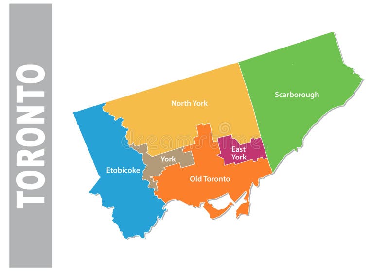
Free with trial Colorful toronto administrative and political vector map. Mapping vectors Colorful toronto administrative and political vector map.
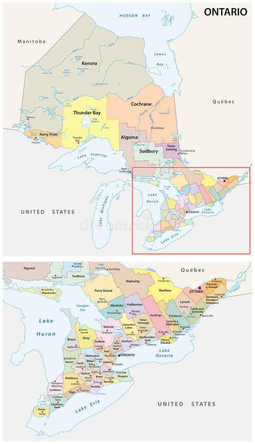
Free with trial Ontario administrative and political map. Canada. Mapping vectors Ontario administrative and political map. Canada
Free with trial Arctic Ocean region north of mainland Europe,political map. From the eastern part of Greenland to Svalbard to Franz Josef Land,with parts of the countries Iceland,Norway Sweden,Finland and Russia. Mapping vectors Arctic Ocean region north of mainland Europe, political map. Arctic Ocean region north of mainland Europe,political map. From the eastern part of Greenland to. Arctic Ocean region north of mainland Europe,political map. From the eastern part of Greenland to Svalbard to Franz Josef Land,with parts of the countries Iceland,Norway Sweden,Finland and Russia.
Free with trial Texas state icon on orange stylized advertisement. Orange stylized banner template with a texas icon. Mapping vectors Texas state icon on orange stylized advertisement. Orange stylized banner template with a texas icon
Free with trial Map of European Union member states after Brexit, English labeling. 27 EU member states, after United Kingdom left. Special member state territories are not included in the map. Illustration. Vector. Mapping vectors Map of European Union member states after Brexit, English labeling. 27 EU member states, after United Kingdom left. Special member state territories are not
Free with trial Street map top view, houses, roads and trees. City landscape plan elements from above, building roofs, bushes and traffic lane vector set. Plan view with roof townhouse and downtown illustration. Mapping vectors Street map top view, houses, roads and trees. City landscape plan elements from above, building roofs, bushes and. Traffic lane vector set. Plan view with roof. Street map top view, houses, roads and trees. City landscape plan elements from above, building roofs, bushes and traffic lane vector set. Plan view with roof townhouse and downtown illustration
Free with trial Color detailed road map, urban street plan city Toronto and Vancouver with colorful neighborhoods and districts, Travel vector poster for design map of roads, rivers and paths. Mapping vectors Color detailed road map, urban street plan city Toronto and Vancouver with colorful neighborhoods and districts, Travel vector. Poster for design map of roads
Free with trial Big data analysis to database. Big data technology managing datas from public to database - concept ideas with vintage color. Mapping vectors Big data analysis to database. Big data technology managing datas from public to database - concept ideas with vintage color
Free with trial Set of travel posters with Beijing, detailed urban street plan city map, Silhouette city skyline, vector artwork, collection of wall tourist decorations. Mapping vectors Set of travel posters with Beijing, detailed urban street plan city map, Silhouette city skyline, vector artwork. Collection of wall tourist decorations
Free with trial Arizona political map with capital Phoenix. State in southwestern region of United States, Part of Western and Mountain States. The Grand Canyon State. Gray illustration on white background. Vector. Mapping vectors Arizona United States political map. Arizona political map with capital Phoenix. State in southwestern region of United States, Part of Western and Mountain. Arizona political map with capital Phoenix. State in southwestern region of United States, Part of Western and Mountain States. The Grand Canyon State. Gray illustration on white background. Vector.
Free with trial East or Atlantic Coast of the United States, political map. Eastern Seaboard states with coastline on Atlantic Ocean highlighted in yellow and States considered part of the East Coast in light yellow. Mapping vectors East or Atlantic Coast of the United States, political map. Eastern Seaboard states with coastline on Atlantic Ocean highlighted in yellow and States
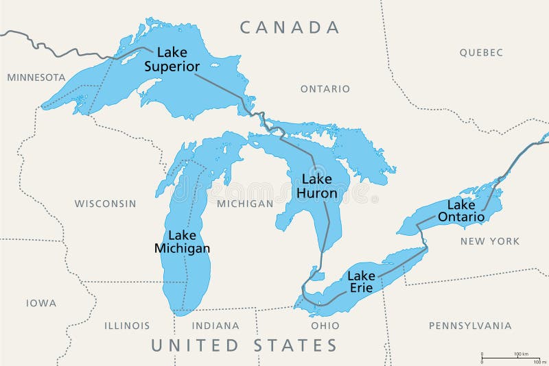
Free with trial Great Lakes of North America, political map. Lake Superior, Michigan, Huron, Erie and Lake Ontario. A series of large interconnected freshwater lakes on or near the border of Canada and United States. Mapping vectors Great Lakes of North America, series of freshwater lakes, political map. Great Lakes of North America, political map. Lake Superior, Michigan, Huron, Erie and. Great Lakes of North America, political map. Lake Superior, Michigan, Huron, Erie and Lake Ontario. A series of large interconnected freshwater lakes on or near the border of Canada and United States.
Free with trial Monaco, Nice and Cannes, gray political map. The coastal strip of Alpes-Maritimes, a department of France, located on the French Riviera and Mediterranean Sea. With microstate Principality of Monaco. Mapping vectors Monaco, Nice and Cannes, coastal strip of Alpes-Maritimes, gray political map. Monaco, Nice and Cannes, gray political map. The coastal strip of Alpes-Maritimes. Monaco, Nice and Cannes, gray political map. The coastal strip of Alpes-Maritimes, a department of France, located on the French Riviera and Mediterranean Sea. With microstate Principality of Monaco.
Free with trial Austria, political map, with the capital Vienna, nine federated states and their capitals. With borders and the neighbor countries. English labeling. Illustration. Vector. Mapping vectors Austria, political map with capital Vienna and nine federated states. Austria, political map, with the capital Vienna, nine federated states and their capitals. Austria, political map, with the capital Vienna, nine federated states and their capitals. With borders and the neighbor countries. English labeling. Illustration. Vector.
Free with trial Vector map of national parks, United States. Mapping vectors Vector map of national parks, United States.
 Sign in