Free with trial A spain province map with 2-digit zip codes. Mapping vectors A spain province map with 2-digit zip codes.
Free with trial Ancestry or Genealogy Icon Set with Family Tree Album, DNA, beak. Ers, chemical family record, etc. Mapping vectors Ancestry or Genealogy Icon Set with Family Tree Album, DNA, beak. Ers, chemical family record, etc
Free with trial Midwest, census region of the United States of America, gray political map of census region 2, consisting of 12 single states. Map with geographical borders and capitals. Isolated illustration. Mapping vectors Midwest, census region of the United States, gray political map. Midwest, census region of the United States of America, gray political map of census region 2. Midwest, census region of the United States of America, gray political map of census region 2, consisting of 12 single states. Map with geographical borders and capitals. Isolated illustration.
Free with trial Ancestry or Genealogy Icon Set web banner w Family Tree Album, f. Ancestry / Genealogy Icon Set web banner with Family Tree Album, family record, etc. Mapping vectors Ancestry or Genealogy Icon Set web banner w Family Tree Album, f. Ancestry / Genealogy Icon Set web banner with Family Tree Album, family record, etc
Free with trial Hawaiian Islands, Sandwich Islands, gray political map. U. S. state of Hawaii with capital Honolulu, and unincorporated territory Midway Atoll. Archipelago in North Pacific Ocean. Illustration. Vector. Mapping vectors Hawaiian Islands, Sandwich Islands, gray political map. U.S. state of Hawaii with capital Honolulu, and unincorporated territory Midway Atoll. Archipelago in
Free with trial Icon GPS technology laying of a route travel, tourism navigation. On the image is presented icon GPS technology laying of a route travel, tourism navigation. Mapping vectors Icon GPS technology laying of a route travel, tourism navigation. On the image is presented icon GPS technology laying of a route travel, tourism navigation
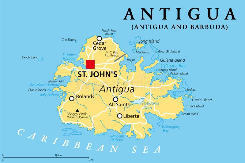
Free with trial Antigua, island in the Lesser Antilles, political map. One of the Leeward Islands in the Caribbean region, and the most populous island of the country of Antigua and Barbuda, with capital St. Johns. Mapping vectors Antigua, island in the Lesser Antilles in the Caribbean, political map. Antigua, island in the Lesser Antilles, political map. One of the Leeward Islands in the. Antigua, island in the Lesser Antilles, political map. One of the Leeward Islands in the Caribbean region, and the most populous island of the country of Antigua and Barbuda, with capital St. Johns.
Free with trial A simple 3D map of Germany. Mapping vectors Map_Germany_3. A simple 3D map of Germany. A simple 3D map of Germany.
Free with trial Autonomous Underwater Vehicle or AUV exploring the depths for wreckage and is remotely controlled from a boat. Two Airplanes fly in the sky. Mapping vectors A remote controlled robot searching underwater for debris of planes, ships or more. Editable Clip Art. Autonomous Underwater Vehicle or AUV exploring the depths. Autonomous Underwater Vehicle or AUV exploring the depths for wreckage and is remotely controlled from a boat. Two Airplanes fly in the sky.
Free with trial Weather forecast pins. Vector illustration of weather forecast background. Mapping vectors Weather forecast pins. Vector illustration of weather forecast background
Free with trial High detailed Russia physical map with labeling. Vector illustration. Mapping vectors High detailed Russia physical map with labeling. Vector illustration
Free with trial West Coast of the United States, with Alaska and Hawaii, political map. Also known as Pacific Coast and Western Seaboard, the coastline along which the Western United States meets the Pacific Ocean. Mapping vectors West Coast of the United States, with Alaska and Hawaii, political map. Also known as Pacific Coast and Western Seaboard, the coastline along which the Western
Free with trial Ancestry or Genealogy Icon Set web banner w Family Tree Album, f. Ancestry / Genealogy Icon Set web banner with Family Tree Album, family record, etc. Mapping vectors Ancestry or Genealogy Icon Set web banner w Family Tree Album, f. Ancestry / Genealogy Icon Set web banner with Family Tree Album, family record, etc
Free with trial Biomes in Brazil,map of 6 ecosystems with natural vegetation. Amazon rainforest,next to thorny scrub and tropical savanna,and ecosystems of wetland,grassland and Atlantic Forest. Mapping vectors Biomes in Brazil, map of six ecosystems with natural vegetation. Biomes in Brazil,map of 6 ecosystems with natural vegetation. Amazon rainforest,next to thorny. Biomes in Brazil,map of 6 ecosystems with natural vegetation. Amazon rainforest,next to thorny scrub and tropical savanna,and ecosystems of wetland,grassland and Atlantic Forest.
Free with trial Southeast Region, South of the United States, gray political map. Geographic and cultural region, also referred to as the Southern United States, American South, Southland, Dixieland, or simply Dixie. Mapping vectors Southeast Region, the South of the United States, gray political map. Southeast Region, South of the United States, gray political map. Geographic and cultural. Southeast Region, South of the United States, gray political map. Geographic and cultural region, also referred to as the Southern United States, American South, Southland, Dixieland, or simply Dixie.
Free with trial GPS Instrument. Illustration of GPS instrument showing route map. Mapping vectors GPS Instrument. Illustration of GPS instrument showing route map
Free with trial Leeward Islands, political map. Part of the Lesser Antilles, north of Windward Islands in the Caribbean. Virgin Islands, Anguilla, St Kitts and Nevis, Antigua and Barbuda, Montserrat, and Guadeloupe. Mapping vectors Leeward Islands, political map, part of Lesser Antilles in the Caribbean. Leeward Islands, political map. Part of the Lesser Antilles, north of Windward Islands. Leeward Islands, political map. Part of the Lesser Antilles, north of Windward Islands in the Caribbean. Virgin Islands, Anguilla, St Kitts and Nevis, Antigua and Barbuda, Montserrat, and Guadeloupe.
Free with trial Clinical Study Web Header Banner & Icon Set. Mapping vectors Clinical Study Web Header Banner & Icon Set. Clinical Study - Web Header Banner and Icon Set
Free with trial Africa map vector illustration. Art. Mapping vectors Africa map vector illustration. Art
Free with trial Abstract Digital Mountains Design. Vector. Mapping vectors Abstract Digital Mountains Design. Vector
Free with trial Medical Healthcare Icons. With DNA Scientific Discovery. Mapping vectors Medical Healthcare Icons. With DNA Scientific Discovery
Free with trial Northeast, census region of the United States of America, gray political map of census region 1, consisting of 9 single states. Map with geographical borders and capitals. Isolated illustration. Mapping vectors Northeast, census region of the United States, gray political map. Northeast, census region of the United States of America, gray political map of census region. Northeast, census region of the United States of America, gray political map of census region 1, consisting of 9 single states. Map with geographical borders and capitals. Isolated illustration.
Free with trial Benelux Union countries, political map. Members of the politico-economic union and formal international intergovernmental cooperation of the European states Belgium, the Netherlands, and Luxembourg. Mapping vectors Benelux Union countries, Belgium, Netherlands, and Luxembourg, political map. Benelux Union countries, political map. Members of the politico-economic union and. Benelux Union countries, political map. Members of the politico-economic union and formal international intergovernmental cooperation of the European states Belgium, the Netherlands, and Luxembourg.
Free with trial City map Chisinau, monochrome detailed plan, vector illustration. Roads, trails and rivers. Mapping vectors City map Chisinau, monochrome detailed plan, vector illustration. Roads, trails and rivers
Free with trial Travel poster, urban street plan city map Jakarta and Manila, vector illustration. Mapping vectors Travel poster, urban street plan city map Jakarta and Manila, vector illustration
Free with trial European Union, isolated on white background, with all single countries and English labeling. All 28 EU members, colored in blue. Political and economic union in Europe. Illustration. Vector. Mapping vectors European Union countries, isolated on white background, English labeling. European Union, isolated on white background, with all single countries and English. European Union, isolated on white background, with all single countries and English labeling. All 28 EU members, colored in blue. Political and economic union in Europe. Illustration. Vector.
Free with trial Gran Canaria political map with capital Las Palmas and important towns. Grand Canary Island, part of Spain, the second most populous Island of Canary Islands, off the Atlantic coast of Africa. Vector. Mapping vectors Gran Canaria, Grand Canary Island, political map, with capital Las Palmas. Gran Canaria political map with capital Las Palmas and important towns. Grand Canary. Gran Canaria political map with capital Las Palmas and important towns. Grand Canary Island, part of Spain, the second most populous Island of Canary Islands, off the Atlantic coast of Africa. Vector.
Free with trial West Coast region of the United States, with Alaska and Hawaii, political map. Also known as Pacific Coast, Pacific Seaboard and Western Seaboard. Alaska, California, Hawaii, Oregon, and Washington. Mapping vectors West Coast region of the United States, with Alaska and Hawaii, political map. Also known as Pacific Coast, Pacific Seaboard and Western Seaboard. Alaska
Free with trial The Maritimes, also called Maritime provinces, a region of Eastern Canada, political map, with capitals, borders and largest cities. The provinces New Brunswick, Nova Scotia, and Prince Edward Island. Mapping vectors The Maritimes, the Maritime provinces of Eastern Canada, political map. The Maritimes, also called Maritime provinces, a region of Eastern Canada, political map. The Maritimes, also called Maritime provinces, a region of Eastern Canada, political map, with capitals, borders and largest cities. The provinces New Brunswick, Nova Scotia, and Prince Edward Island.
Free with trial High detailed Turkey physical map. Vector illustration. Mapping vectors High detailed Turkey physical map. Vector illustration
Free with trial Pennsylvania counties, political map. Commonwealth of Pennsylvania, a state of the Mid-Atlantic and Northeastern United States, subdivided into 67 counties. Map with boundaries and county names. Mapping vectors Commonwealth of Pennsylvania, U.S. state subdivided into 67 counties, political map. Pennsylvania counties, political map. Commonwealth of Pennsylvania, a state. Pennsylvania counties, political map. Commonwealth of Pennsylvania, a state of the Mid-Atlantic and Northeastern United States, subdivided into 67 counties. Map with boundaries and county names.
Free with trial Road vector map of the Italian region Tuscany. Mapping vectors Road vector map of the Italian region Tuscany.
Free with trial Drone with video camera flys on assigned route and transmit streaming fpv video on screen tablet. Navigation digital map of autonomous or wireless remoted drone. Mapping vectors Drone with video camera flys on assigned route and transmit streaming fpv video on screen tablet. Navigation digital map. Of autonomous or wireless remoted
Free with trial New England, a region of the United States, gray political map. Maine, Vermont, New Hampshire, Massachusetts, Rhode Island and Connecticut with Capitals. Bordered by Mid-Atlantic region and by Canada. Mapping vectors New England, a region of the United States, gray political map. Maine, Vermont, New Hampshire, Massachusetts, Rhode Island and Connecticut with Capitals
Free with trial Gotland, gray political map. Largest island in Sweden, fully surrounded by the Baltic Sea. The province of Gotland with capital Visby including Faro, Gotska Sandon and Karlso Islands Lilla and Stora. Mapping vectors Gotland, the largest island of Sweden, gray political map. Gotland, gray political map. Largest island in Sweden, fully surrounded by the Baltic Sea. The. Gotland, gray political map. Largest island in Sweden, fully surrounded by the Baltic Sea. The province of Gotland with capital Visby including Faro, Gotska Sandon and Karlso Islands Lilla and Stora.
Free with trial Map icons. A set of map and navigation icons. Mapping vectors Map icons. A set of map and navigation icons
Free with trial French Riviera, political map. Mediterranean coastline of the southeast corner of France, known as Cote dAzur (Azure Coast). Usually considered to extend from Toulon in the west to Menton in the east. Mapping vectors French Riviera, Cote dAzur, a Mediterranean coastline, political map. French Riviera, political map. Mediterranean coastline of the southeast corner of France. French Riviera, political map. Mediterranean coastline of the southeast corner of France, known as Cote dAzur (Azure Coast). Usually considered to extend from Toulon in the west to Menton in the east.
Free with trial Neom, gray political map. Saudi megacity being built in the Tabuk Province of northwestern Saudi Arabia, North of the Red Sea and across Gulf of Aqaba. Planned as a smart city and tourist destination. Mapping vectors Neom, megacity project in Saudi Arabia, gray political map. Neom, gray political map. Saudi megacity being built in the Tabuk Province of northwestern Saudi. Neom, gray political map. Saudi megacity being built in the Tabuk Province of northwestern Saudi Arabia, North of the Red Sea and across Gulf of Aqaba. Planned as a smart city and tourist destination.
Free with trial Scientific Process Icon Set with Web Header Banner. Mapping vectors Scientific Process Icon Set with Web Header Banner. Scientific Process Icon Set & Web Header Banner
Free with trial France map with the new regions and the most important cities and rivers. Mapping vectors France map with the new regions and the most important cities and rivers.
Free with trial High detailed Sweden physical map. Vector illustration. Mapping vectors High detailed Sweden physical map. Vector illustration
Free with trial Molokai road map. Road map of the Hawaiian island molokai. Mapping vectors Molokai road map. Road map of the Hawaiian island molokai
Free with trial Ushuaia town map with landmark advertising. Argentina sightseeing places like Bridal Veil waterfall, Capsula del Tiempo Philco, Casa Beban, monument Galicia, church, museum del Fin del Mundo. Mapping vectors Ushuaia town map with sights, landmark advertising. Ushuaia town map with landmark advertising. Argentina sightseeing places like Bridal Veil waterfall, Capsula. Ushuaia town map with landmark advertising. Argentina sightseeing places like Bridal Veil waterfall, Capsula del Tiempo Philco, Casa Beban, monument Galicia, church, museum del Fin del Mundo
Free with trial Cute little boy cartoon with globe. Illustration of Cute little boy cartoon with globe. Mapping vectors Cute little boy cartoon with globe. Illustration of Cute little boy cartoon with globe
Free with trial Vector Illustration Map Of South America In Modern Colors And Name Labels. Mapping vectors Vector Illustration Map Of South America In Modern Colors And Name Labels. Vector Illustration Cool Map Of South America In Modern Colors And Name Labels
Free with trial Mobile gps navigation on mobile phone with map. Search location on photos. Mapping vectors Mobile gps navigation on mobile phone with map. Search location on photos
Free with trial Mobile gps navigation on mobile phone with map. Search location on photos. Mapping vectors Mobile gps navigation on mobile phone with map. Search location on photos
Free with trial Blank gray similar Mexico map isolated on white background. American country. Vector flat icon with shadow. Mapping vectors Blank gray similar Mexico map isolated on white background. American country. Vector flat icon with shadow
Free with trial Web of ashalted roads vector. Web of ashalted roads with crossroads vector. Mapping vectors Web of ashalted roads vector. Web of ashalted roads with crossroads vector
Free with trial Russia and United States,maritime boundary,gray political map. The Chukchi Peninsula of Russian Far East,and Seward Peninsula of Alaska,separated by Bering Strait between Pacific and Arctic Ocean. Mapping vectors Russia and United States, maritime boundary, gray political map. Russia and United States,maritime boundary,gray political map. The Chukchi Peninsula of Russian. Russia and United States,maritime boundary,gray political map. The Chukchi Peninsula of Russian Far East,and Seward Peninsula of Alaska,separated by Bering Strait between Pacific and Arctic Ocean.
Free with trial Big Data concept. Abstract vector background. Eps8. RGB Global colors. Mapping vectors Big Data concept. Abstract vector background. Eps8. RGB Global colors
Free with trial Traveling map of coober pedy town. Australian city map with landmarks. Catholic and Serbian orthodox church, Ralph Cooper Hutchinson monument, spaceship, Toms and Umoona Opal mine, museum. Mapping vectors Landmark map for Australian Coober Pedy town, city. Traveling map of coober pedy town. Australian city map with landmarks. Catholic and Serbian orthodox church. Traveling map of coober pedy town. Australian city map with landmarks. Catholic and Serbian orthodox church, Ralph Cooper Hutchinson monument, spaceship, Toms and Umoona Opal mine, museum
Free with trial Major volcanoes in Indonesia, political map. Southeast Asian country dominated by volcanoes, formed by subduction zones, and part of Ring of Fire. Most notable are Krakatau, Merapi, Tambora and Toba. Mapping vectors Major volcanoes in Indonesia, part of the Ring of Fire, political map. Major volcanoes in Indonesia, political map. Southeast Asian country dominated by. Major volcanoes in Indonesia, political map. Southeast Asian country dominated by volcanoes, formed by subduction zones, and part of Ring of Fire. Most notable are Krakatau, Merapi, Tambora and Toba.
Free with trial DNA test infographic. Science medical vector background. Big genomic data visualization. Genealogy sequence. Concept of a paternity test or research on genetic diseases. Encoded information. Mapping vectors DNA test visualization. Vector science background. Encoded genealogy sequence. DNA test infographic. Science medical vector background. Big genomic data. DNA test infographic. Science medical vector background. Big genomic data visualization. Genealogy sequence. Concept of a paternity test or research on genetic diseases. Encoded information
Free with trial High detailed Romania physical map with labeling. Vector illustration. Mapping vectors High detailed Romania physical map with labeling. Vector illustration
Free with trial The Caribbean Sea and its islands, gray political map. The Caribbean, subregion of the Americas, with the West Indies, compromising independent island countries and dependencies in three archipelagos. Mapping vectors The Caribbean Sea and its islands, gray political map. The Caribbean, subregion of the Americas, with the West Indies, compromising independent island
Free with trial Constructor roads set. Flat road elements. Create your own city and rail road. Connectable road elements. Vector illustration. Mapping vectors Constructor roads set. Flat road elements. Create your own city and rail road. Connectable road elements. Vector. Illustration
Free with trial Nordfriesland, or North Frisia, political map. Northernmost district of Germany, part of Schleswig-Holstein, with capital Husum and the five large islands Sylt, Foehr, Amrum, Pellworm and Nordstrand. Mapping vectors Nordfriesland, or North Frisia, district of Germany, political map. Nordfriesland, or North Frisia, political map. Northernmost district of Germany, part of. Nordfriesland, or North Frisia, political map. Northernmost district of Germany, part of Schleswig-Holstein, with capital Husum and the five large islands Sylt, Foehr, Amrum, Pellworm and Nordstrand.
Free with trial New York State economic regions, multi colored political map. Major economic regions of New York, a state of the Northeastern United States, and one of the Mid-Atlantic states. Illustration. Vector. Mapping vectors New York State economic regions, multi colored political map. Major economic regions of New York, a state of the Northeastern United States, and one of the Mid
Free with trial Scientific Process Icon Set with hypothesis, analysis, etc. Mapping vectors Scientific Process Icon Set with hypothesis, analysis, etc. Scientific Process Icon Set - hypothesis, analysis, etc
Free with trial Lake Titicaca, gray political map. Large freshwater lake in the Andes mountains on the border of Bolivia and Peru. Often called highest navigable lake in the World, and largest lake in South America. Mapping vectors Lake Titicaca, on the border of Bolivia and Peru, gray political map. Lake Titicaca, gray political map. Large freshwater lake in the Andes mountains on the. Lake Titicaca, gray political map. Large freshwater lake in the Andes mountains on the border of Bolivia and Peru. Often called highest navigable lake in the World, and largest lake in South America.
Free with trial Kentucky, KY, gray political map, with capital Frankfort and largest cities. Commonwealth of Kentucky. State in Southeastern region of United States of America. Bluegrass State. Illustration. Vector. Mapping vectors Kentucky, KY, gray political map, Bluegrass State, Southeastern US state. Kentucky, KY, gray political map, with capital Frankfort and largest cities. Kentucky, KY, gray political map, with capital Frankfort and largest cities. Commonwealth of Kentucky. State in Southeastern region of United States of America. Bluegrass State. Illustration. Vector.
Free with trial Lesser Sunda Islands, Indonesia, gray political map. Nusa Tenggara Islands, archipelago in Southeast Asia. Part of volcanic Sunda Arc. Bali, Lombok, Sumbawa, Sumba, Flores, Timor and smaller islands. Mapping vectors Lesser Sunda Islands, Nusa Tenggara Islands, Indonesia, gray political map. Lesser Sunda Islands, Indonesia, gray political map. Nusa Tenggara Islands. Lesser Sunda Islands, Indonesia, gray political map. Nusa Tenggara Islands, archipelago in Southeast Asia. Part of volcanic Sunda Arc. Bali, Lombok, Sumbawa, Sumba, Flores, Timor and smaller islands.
Free with trial GPS phone navigation - mobile gps and tracking concept. Hand holding a mobile phone with city map. Mapping vectors GPS phone navigation - mobile gps and tracking concept. Hand holding a mobile phone with city map.
Free with trial Administrative map of the Italian region Basilicata. Administrative and political map of the Italian region Basilicata. Mapping vectors Administrative map of the Italian region Basilicata. Administrative and political map of the Italian region Basilicata
Free with trial West South Central states, gray political map. United States Census division of the South region, consisting of the states Arkansas, Louisiana, Oklahoma, and Texas. Illustration. Vector. Mapping vectors West South Central states in the South region of the USA, gray political map. West South Central states, gray political map. United States Census division of the. West South Central states, gray political map. United States Census division of the South region, consisting of the states Arkansas, Louisiana, Oklahoma, and Texas. Illustration. Vector
Free with trial The goa vector map, india. Mapping vectors Goa vector map, india. The goa vector map, india. The goa vector map, india.
Free with trial Delaware, DE, gray political map. State in Mid-Atlantic region of United States of America. Capital Dover. The First State. The Small Wonder. Blue Hen State. The Diamond State. Illustration. Vector. Mapping vectors Delaware, DE, gray political map, The First State. Delaware, DE, gray political map. State in Mid-Atlantic region of United States of America. Capital Dover. The. Delaware, DE, gray political map. State in Mid-Atlantic region of United States of America. Capital Dover. The First State. The Small Wonder. Blue Hen State. The Diamond State. Illustration. Vector.
Free with trial Helsinki district map. Administrative, district map of the Finnish capital Helsinki. Mapping vectors Helsinki district map. Administrative, district map of the Finnish capital Helsinki
Free with trial Glass map pin set. Vector set of transparent glossy map pins. Mapping vectors Glass map pin set. Vector set of transparent glossy map pins
Free with trial High detailed Europe road and highway map with labeling. Vector illustration. Mapping vectors High detailed Europe road map with labeling. High detailed Europe road and highway map with labeling. Vector illustration. High detailed Europe road and highway map with labeling. Vector illustration.
Free with trial A stylized map of the german island Amrum in the North Sea. Amrum is a german tourist magnet during summer season. Mapping vectors Stylized map of the german island Amrum. A stylized map of the german island Amrum in the North Sea. Amrum is a german tourist magnet during summer season. A stylized map of the german island Amrum in the North Sea. Amrum is a german tourist magnet during summer season.
Free with trial Cyclades, group of Greek islands in the Aegean Sea, gray political map. Southeast of mainland Greece. Cyclades means encircling referring to the circle the islands form around the sacred island Delos. Mapping vectors Cyclades, group of Greek islands in the Aegean Sea, gray political map. Southeast of mainland Greece. Cyclades means encircling referring to the circle the
Free with trial Texas icon on blue and black halftone grunge ad. Blue and black halftone grungy advertisement with a lonestar state icon. Mapping vectors Texas icon on blue and black halftone grunge ad. Blue and black halftone grungy advertisement with a lonestar state icon
Free with trial Vector map Saint john, US Virgin Islands. Mapping vectors Vector map Saint john, US Virgin Islands.
Free with trial Alabama, AL, gray political map, with capital Montgomery, large and important cities. State in the Southeastern region of United States, nicknamed Yellowhammer State, Heart of Dixie, and Cotton State. Mapping vectors Alabama, AL, gray political map, US state, The Yellowhammer State. Alabama, AL, gray political map, with capital Montgomery, large and important cities. State in. Alabama, AL, gray political map, with capital Montgomery, large and important cities. State in the Southeastern region of United States, nicknamed Yellowhammer State, Heart of Dixie, and Cotton State.
Free with trial Hainan,smallest and southernmost province of China,PRC,political map. Consisting of Hainan Island and various small islands in the South China Sea,south of Leizhou Peninsula,with capital Haikou. Mapping vectors Hainan, southernmost province of China, PRC, political map. Hainan,smallest and southernmost province of China,PRC,political map. Consisting of Hainan Island and. Hainan,smallest and southernmost province of China,PRC,political map. Consisting of Hainan Island and various small islands in the South China Sea,south of Leizhou Peninsula,with capital Haikou.
Free with trial United States major river basins, political map. Nineteen major river basins, highlighted in different colors. Map with the silhouette of the USA, also showing the borders of the individual states. Mapping vectors United States major river basins, political map. Nineteen major river basins, highlighted in different colors. Map with the silhouette of the USA, also showing
Free with trial South America geographical regions, multi colored political map. Four main regions of the continent, Caribbean South America, the Guianas, Andean States, Brazil and the Southern Cone of the continent. Mapping vectors South America geographical regions, multi colored political map. Four main regions of the continent, Caribbean South America, the Guianas, Andean States
 Sign in