Free with trial Koh Samui beach and road vector map. Mapping vectors Koh Samui beach and road vector map.
Free with trial Map of the watersheds in the United States. Mapping vectors Map of the watersheds in the United States.
Free with trial Canada - Highly detailed editable political map with labeling. Vector illustration. Mapping vectors Canada - Highly detailed editable political map with labeling. Vector illustration
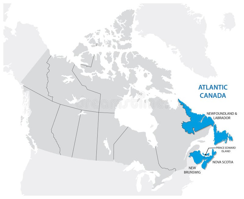
Free with trial Survey map of the Canadian Atlantic States, Atlantic canada. Mapping vectors Survey map of the Canadian Atlantic States, Atlantic canada. Survey map of the four Canadian Atlantic States, Atlantic canada
Free with trial Find map concept flat design,. Illustration. Mapping vectors Find map concept flat design,. Illustration
Free with trial Mind map structured thinking ideas hierarchy organization vector concept illustration laptop. Drawing. Mapping vectors Mind map structured thinking ideas hierarchy organization vector concept illustration laptop. Drawing
Free with trial Christmas gift. Abstract background with a Christmas gift. Mapping vectors Christmas gift. Abstract background with a Christmas gift
Free with trial Map of California State and It`s Roads - Highly Detailed Map of California State vector illustration - All elements are separated in editable layers clearly labeled. Mapping vectors Map of California State and It`s Roads. Highly Detailed Map of California State vector illustration - All elements are separated in editable layers clearly
Free with trial Administrative political map of the Guatemalan capital Guatemala City. Mapping vectors Administrative political map of the Guatemalan capital Guatemala City.
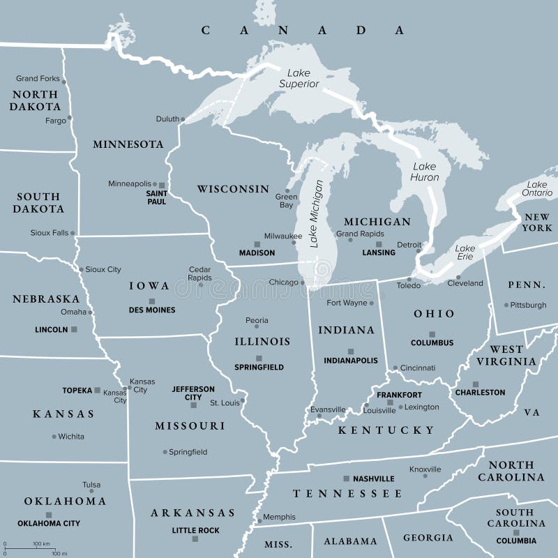
Free with trial Midwest Region of the United States, gray political map. Midwestern United States or American Midwest, a geographic region, south of Great Lakes, bordered by Mid-Atlantic, the South and Great Plains. Mapping vectors Midwest Region of the United States, American Midwest, gray political map. Midwest Region of the United States, gray political map. Midwestern United States or. Midwest Region of the United States, gray political map. Midwestern United States or American Midwest, a geographic region, south of Great Lakes, bordered by Mid-Atlantic, the South and Great Plains.
Free with trial Liguria and the Italian Riviera, the Ligurian Riviera, political map. Region of north-western Italy, with capital Genoa. A narrow coastal strip between Ventimiglia and La Spezia, on the Ligurian Sea. Mapping vectors Liguria and the Italian Riviera, the Ligurian Riviera, political map. Region of north-western Italy, with capital Genoa. A narrow coastal strip between
Free with trial 17 of 50 sets, US State Posters with name and Information in 3 Design Styles, Detailed vector art print Ohio map. Travel illustration. Mapping vectors 17 of 50 sets, US State Posters with name and Information in 3 Design Styles, Detailed vector art print Ohio map. Travel illustration
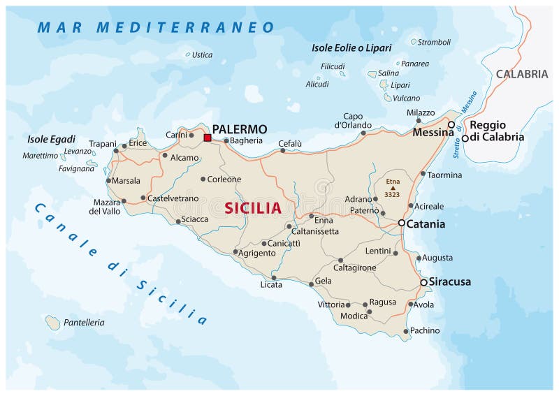
Free with trial Road map of the italian mediterranean island Sicily. Mapping vectors Road map of the italian mediterranean island Sicily. Road vector map of the italian mediterranean island Sicily
Free with trial Road map of the Indian state Sikkim. Mapping vectors Road map of the Indian state Sikkim. Road vector map of the Indian state Sikkim
Free with trial Oregon National Park Trails Map T-Shirt Design. T shirt Template With a Map of National Parks, Local Attractions, Hiking and Camping Routes for POD Tee, Apparel, Clothing, SVG and Screen Print. Mapping vectors Oregon National Park Trails Map T-Shirt Design. Oregon Attraction Tee Template. Oregon National Park Trails Map T-Shirt Design. T shirt Template With a Map of. Oregon National Park Trails Map T-Shirt Design. T shirt Template With a Map of National Parks, Local Attractions, Hiking and Camping Routes for POD Tee, Apparel, Clothing, SVG and Screen Print
Free with trial Republic of the congo road vector map. Mapping vectors Republic of the congo road vector map.
Free with trial Vector map of the Republic of Seychelles. Mapping vectors Vector map of the Republic of Seychelles.
Free with trial Central Asia,or Middle Asia,colored political map. Region of Asia from Caspian Sea to western China,and from Russia to Afghanistan. Kazakhstan,Kyrgyzstan,Tajikistan,Turkmenistan,and Uzbekistan. Mapping vectors Central Asia, the Middle Asia countries, colored political map. Central Asia,or Middle Asia,colored political map. Region of Asia from Caspian Sea to western. Central Asia,or Middle Asia,colored political map. Region of Asia from Caspian Sea to western China,and from Russia to Afghanistan. Kazakhstan,Kyrgyzstan,Tajikistan,Turkmenistan,and Uzbekistan.
Free with trial Earth background. With radiate circles, vector illustration. Mapping vectors Earth background. With radiate circles, vector illustration
Free with trial Strait of Gibraltar, political map. Also known as Straits of Gibraltar. Narrow strait, connecting the Atlantic Ocean to the Mediterranean Sea, separating the Iberian Peninsula from Morocco and Africa. Mapping vectors Strait of Gibraltar, also known as Straits of Gibraltar, political map. Strait of Gibraltar, political map. Also known as Straits of Gibraltar. Narrow strait. Strait of Gibraltar, political map. Also known as Straits of Gibraltar. Narrow strait, connecting the Atlantic Ocean to the Mediterranean Sea, separating the Iberian Peninsula from Morocco and Africa.
Free with trial Set of topographic contour line maps in circles. Set of eight abstract topographic contour line maps showing elevation and terrain patterns. Mapping vectors Set of topographic contour line maps in circles. Set of eight abstract topographic contour line maps showing elevation and terrain patterns
Free with trial Australia, political map, with the capital Canberra, internal administrative boundaries, and most important cities. Officially the Commonwealth of Australia, a sovereign country. Illustration. Vector. Mapping vectors Australia, political map with internal administrative boundaries. Australia, political map, with the capital Canberra, internal administrative boundaries, and. Australia, political map, with the capital Canberra, internal administrative boundaries, and most important cities. Officially the Commonwealth of Australia, a sovereign country. Illustration. Vector.
Free with trial Science and Research Icon with one part of the scientific process. Mapping vectors Science and Research Icon with one part of the scientific process. Science & Research Icon showing one part of the scientific process
Free with trial New England region of United States, political map with borders, capitals and most important cities. Comprising U. S. states Maine, Vermont, New Hampshire, Massachusetts, Rhode Island and Connecticut. Mapping vectors New England region of United States, political map. With borders, capitals and most important cities. Comprising U.S. states Maine, Vermont, New Hampshire. New England region of United States, political map with borders, capitals and most important cities. Comprising U.S. states Maine, Vermont, New Hampshire, Massachusetts, Rhode Island and Connecticut.
Free with trial Map of the australian Iceland tasmania. Vector map of the australian Iceland tasmania. Mapping vectors Map of the australian Iceland tasmania. Vector map of the australian Iceland tasmania
Free with trial Costa Rica and Panama,gray political map,with the Isthmus of Panama and the Darien Gap. Narrow strip of land and region between the Caribbean Sea and Pacific Ocean,linking North and South America. Mapping vectors Costa Rica and Panama, Isthmus of Panama, gray political map. Costa Rica and Panama,gray political map,with the Isthmus of Panama and the Darien Gap. Narrow. Costa Rica and Panama,gray political map,with the Isthmus of Panama and the Darien Gap. Narrow strip of land and region between the Caribbean Sea and Pacific Ocean,linking North and South America.
Free with trial Wavy topographic relief with neon lights. Geometric shapes with engraved ornament and illumination. Abstract background. Vector 3d illustration. Modern cover design. Disco or nightlife decoration. Mapping vectors Neon glowing light geometric shapes. Wavy topographic relief with neon lights. Geometric shapes with engraved ornament and illumination. Abstract background. Wavy topographic relief with neon lights. Geometric shapes with engraved ornament and illumination. Abstract background. Vector 3d illustration. Modern cover design. Disco or nightlife decoration
Free with trial A functional set of twelve multi-directional black arrows, including double-headed, four-way expansion, corner turn, and dashed lines, specifically designed for website interfaces, mapping. Mapping vectors Multi Directional Interface Arrows. A functional set of twelve multi-directional black arrows, including double-headed, four-way expansion, corner turn, and. A functional set of twelve multi-directional black arrows, including double-headed, four-way expansion, corner turn, and dashed lines, specifically designed for website interfaces, mapping
Free with trial Road map of the brazilian state paraiba. Mapping vectors Road map of the brazilian state paraiba. Road vector map of the brazilian state paraiba
Free with trial Medical Healthcare Icons with People. Scientific Discovery. Mapping vectors Medical Healthcare Icons with People. Scientific Discovery
Free with trial Costa Rica and Panama,political map,with the Isthmus of Panama and the Darien Gap. Narrow strip of land and region between the Caribbean Sea and the Pacific Ocean,linking North and South America. Mapping vectors Costa Rica and Panama, Isthmus of Panama and Darien Gap, political map. Costa Rica and Panama,political map,with the Isthmus of Panama and the Darien Gap. Narrow. Costa Rica and Panama,political map,with the Isthmus of Panama and the Darien Gap. Narrow strip of land and region between the Caribbean Sea and the Pacific Ocean,linking North and South America.
Free with trial Travel poster, urban street plan city map Hamburg and Stuttgart, vector illustration. Detailed city plan for design. Mapping vectors Travel poster, urban street plan city map Hamburg and Stuttgart, vector illustration. Detailed city plan for design
Free with trial Road map of the indonesian island of Lombok. Mapping vectors Road map of the indonesian island of Lombok. Vector road map of the indonesian island of Lombok
Free with trial Map of east Africa region. Vector color map of east Africa region. Mapping vectors Map of east Africa region. Vector color map of east Africa region
Free with trial Chicago cooorful neighborhood vector map. Mapping vectors Chicago cooorful neighborhood vector map.
Free with trial High detailed Asia physical map with rivers and surface elements. Vector illustration. Mapping vectors High detailed Asia physical map. High detailed Asia physical map with rivers and surface elements. Vector illustration. High detailed Asia physical map with rivers and surface elements. Vector illustration.
Free with trial Administrative, roads and political vector map of the Israeli city of Tel Aviv-Jaffa. Mapping vectors Administrative, roads and political map of the Israeli city of Tel Aviv-Jaffa. Administrative, roads and political vector map of the Israeli city of Tel Aviv. Administrative, roads and political vector map of the Israeli city of Tel Aviv-Jaffa
Free with trial Novaya Zemlya,archipelago in northern Russia,political map. Situated in Arctic Ocean,between Barents Sea and Kara Sea,consisting of Severny Island and Yuzhny Island. Nuclear weapons testing venue. Mapping vectors Novaya Zemlya, archipelago in northern Russia, political map. Novaya Zemlya,archipelago in northern Russia,political map. Situated in Arctic Ocean,between. Novaya Zemlya,archipelago in northern Russia,political map. Situated in Arctic Ocean,between Barents Sea and Kara Sea,consisting of Severny Island and Yuzhny Island. Nuclear weapons testing venue.
Free with trial Naxos and Lesser Cyclades, Greek islands, gray political map. Island group in the Aegean Sea, part of the Cyclades archipelago. Popular tourist destination with a number of beaches and several ruins. Mapping vectors Naxos and Lesser Cyclades, Greek islands, gray political map. Island group in the Aegean Sea, part of the Cyclades archipelago. Popular tourist destination
Free with trial Corsica, gray political map. French island in the Mediterranean Sea, north of Italian island Sardinia, with capital Ajaccio. One of the 18 regions of France and a territorial collectivity of France. Mapping vectors Corsica, gray political map, French island north of Sardinia. Corsica, gray political map. French island in the Mediterranean Sea, north of Italian island. Corsica, gray political map. French island in the Mediterranean Sea, north of Italian island Sardinia, with capital Ajaccio. One of the 18 regions of France and a territorial collectivity of France.
Free with trial Nordic Council members, political map. Cooperation among the Nordic states Denmark, Finland, Iceland, Norway and Sweden, the autonomous territories Faroe Islands and Greenland, and the region Aland. Mapping vectors Nordic Council members, Nordic countries cooperation, political map. Nordic Council members, political map. Cooperation among the Nordic states Denmark, Finland. Nordic Council members, political map. Cooperation among the Nordic states Denmark, Finland, Iceland, Norway and Sweden, the autonomous territories Faroe Islands and Greenland, and the region Aland.
Free with trial High detailed China physical map with labeling. Vector illustration. Mapping vectors High detailed China physical map with labeling. Vector illustration
Free with trial High detailed China physical map with labeling. Vector illustration. Mapping vectors High detailed China physical map with labeling. Vector illustration
Free with trial Windward Islands political map. Islands of the Lesser Antilles, south of the Leeward Islands in the Caribbean Sea. From Dominica, Martinique, Saint Lucia, Saint Vincent and the Grenadines, to Grenada. Mapping vectors Windward Islands, political map, islands of Lesser Antilles in the Caribbean. Windward Islands political map. Islands of the Lesser Antilles, south of the. Windward Islands political map. Islands of the Lesser Antilles, south of the Leeward Islands in the Caribbean Sea. From Dominica, Martinique, Saint Lucia, Saint Vincent and the Grenadines, to Grenada.
Free with trial Road map of the Portuguese island of Madeira. Mapping vectors Road map of the Portuguese island of Madeira.
Free with trial Texas icon on cracked gold backdrop. Gold cracked background with a texas state icon. Mapping vectors Texas icon on cracked gold backdrop. Gold cracked background with a texas state icon
Free with trial High detailed Sweden physical map with labeling. Vector illustration. Mapping vectors High detailed Sweden physical map with labeling. Vector illustration
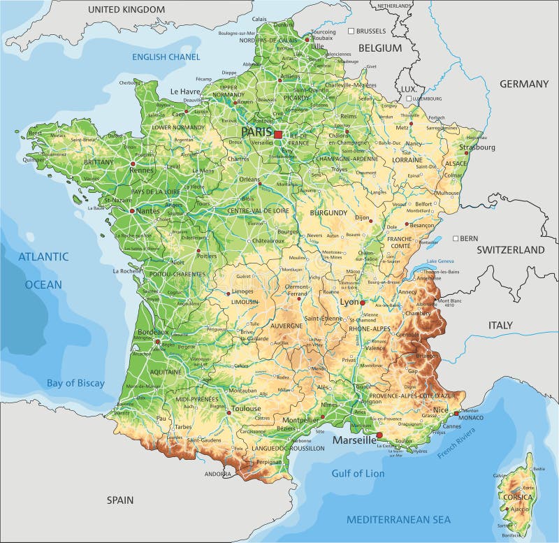
Free with trial High detailed France physical map with labeling. Vector illustration. Mapping vectors High detailed France physical map with labeling. Vector illustration
Free with trial A collection of four distinct Guinea map illustrations, showcasing different visual styles and techniques. The maps are presented in a clean and simple design, with a white background and a yellow header. The illustrations include a dotted map, a solid black silhouette, and two outline styles, offering versatility for various uses. Mapping vectors Guinea Map Vector Illustrations. A collection of four distinct Guinea map illustrations, showcasing different visual styles and techniques. The maps are. A collection of four distinct Guinea map illustrations, showcasing different visual styles and techniques. The maps are presented in a clean and simple design, with a white background and a yellow header. The illustrations include a dotted map, a solid black silhouette, and two outline styles, offering versatility for various uses.
Free with trial High detailed Canada physical map with labeling. Vector illustration. Mapping vectors High detailed Canada physical map with labeling. Vector illustration
Free with trial Texas icon on red cracked web button. Red cracked web icon with a texas state icon. Mapping vectors Texas icon on red cracked web button. Red cracked web icon with a texas state icon
Free with trial Medical Healthcare Icons w People Charting Disease or Scientific Discovery Web Header Banner. Mapping vectors Medical Healthcare Icons with People Charting Disease / Scientific Discovery Web Header Banner. Medical Healthcare Icons w People Charting Disease or Scientific. Medical Healthcare Icons w People Charting Disease or Scientific Discovery Web Header Banner
Free with trial Yucatan Peninsula political map. Large peninsula in southeastern Mexico and adjectants portions of Belize and Guatemala, separating the Gulf of Mexico and Caribbean Sea. With El Salvador and Honduras. Mapping vectors Yucatan Peninsula political map, large peninsula in southeastern Mexico. Yucatan Peninsula political map. Large peninsula in southeastern Mexico and adjectants. Yucatan Peninsula political map. Large peninsula in southeastern Mexico and adjectants portions of Belize and Guatemala, separating the Gulf of Mexico and Caribbean Sea. With El Salvador and Honduras.
Free with trial Hainan, the smallest and southernmost province of China, PRC, gray political map. Hainan Island with capital Haikou, and various smaller islands in the South China Sea, south of the Leizhou Peninsula. Mapping vectors Hainan, southernmost province of China, PRC, gray political map. Hainan, the smallest and southernmost province of China, PRC, gray political map. Hainan Island. Hainan, the smallest and southernmost province of China, PRC, gray political map. Hainan Island with capital Haikou, and various smaller islands in the South China Sea, south of the Leizhou Peninsula.
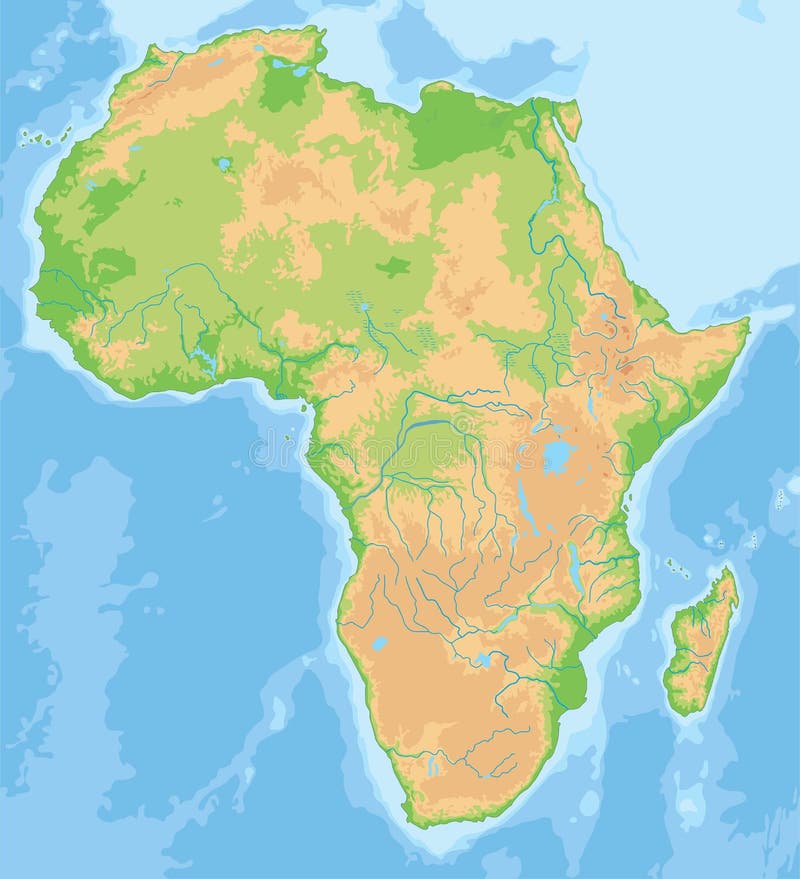
Free with trial High detailed Africa physical map with rivers and surface elements. Mapping vectors High detailed Africa physical map. High detailed Africa physical map with rivers and surface elements. High detailed Africa physical map with rivers and surface elements.
Free with trial High detailed Europe physical map with rivers and surface elements. Vector illustration. Mapping vectors High detailed Europe physical map. High detailed Europe physical map with rivers and surface elements. Vector illustration. High detailed Europe physical map with rivers and surface elements. Vector illustration.
Free with trial Scientific Process Icon Set with hypothesis, analysis, etc. Mapping vectors Scientific Process Icon Set with hypothesis, analysis, etc. Scientific Process Icon Set - hypothesis, analysis, etc
Free with trial A map of the North Japanese island Hokkaido. Mapping vectors A map of the North Japanese island Hokkaido.
Free with trial Global North and Global South, political map of the World showing countries classified by their economics. Developed countries highlighted in blue, and developing and least developed countries in red. Mapping vectors Global North and Global South, political map of the World. Showing countries classified by their economics. Developed countries highlighted in blue, and. Global North and Global South, political map of the World showing countries classified by their economics. Developed countries highlighted in blue, and developing and least developed countries in red.
Free with trial Set of 24 Digital Marketing web icons in line style. Social, networks, feedback, communication, marketing, ecommerce. Vector illustration. Mapping vectors Set of 24 Digital Marketing web icons in line style. Social, networks, feedback, communication, marketing, ecommerce. Vector illustration
Free with trial Geographic regions of the United States, political map. Five regions, according to their geographic position on the continent. Common but unofficial way of referring to regions of the United States. Mapping vectors Geographic regions of the United States of America, political map. Geographic regions of the United States, political map. Five regions, according to their. Geographic regions of the United States, political map. Five regions, according to their geographic position on the continent. Common but unofficial way of referring to regions of the United States.
Free with trial Vector road map of island Borneo, Kalimantan. Mapping vectors Vector road map of island Borneo, Kalimantan.
Free with trial Cartoon Race Track with Cars and Landscape Top View Auto Competition Topography Concept Flat Design Style. Vector illustration of Racetrack. Mapping vectors Cartoon Race Track with Cars Top View. Vector. Cartoon Race Track with Cars and Landscape Top View Auto Competition Topography Concept Flat Design Style. Vector. Cartoon Race Track with Cars and Landscape Top View Auto Competition Topography Concept Flat Design Style. Vector illustration of Racetrack
Free with trial Vector population map of the republic of india. Mapping vectors Vector population map of the republic of india.
Free with trial Detailed North America Political map in Mercator projection. Clearly labeled. Separated layers. Mapping vectors Detailed North America Political map in Mercator projection. Clearly labeled. Separated layers
Free with trial Map of Panhandle in the United States Alaska. Alexander Archipelago. Mapping vectors Map of Panhandle in the United States Alaska. Alexander Archipelago
Free with trial Forecast weather isobar on american night map, meteorology wind fronts and vector temperature diagram. USA map for weather forecast with pressure and wind charts, synoptic prediction isobar. Mapping vectors Forecast weather isobar on american night map. Meteorology wind fronts and vector temperature diagram. USA map for weather forecast with pressure and wind. Forecast weather isobar on american night map, meteorology wind fronts and vector temperature diagram. USA map for weather forecast with pressure and wind charts, synoptic prediction isobar
Free with trial Southwest region of United States, colored map. Also Southwestern United States, American Southwest, or simply Southwest, a geographic region, consisting of Arizona, New Mexico, Oklahoma, and Texas. Mapping vectors Southwest region of the United States, multi colored map. Southwest region of United States, colored map. Also Southwestern United States, American Southwest, or. Southwest region of United States, colored map. Also Southwestern United States, American Southwest, or simply Southwest, a geographic region, consisting of Arizona, New Mexico, Oklahoma, and Texas.
Free with trial High detailed Czech Republic physical map with labeling. Vector illustration. Mapping vectors High detailed Czech Republic physical map with labeling. Vector illustration
Free with trial Electronic music festival. Modern posters design. Electro party invitation. Abstract background. Black, golden and white wavy textures. Vector illustration. Club invitation template. Mapping vectors Electronic music festival. Modern posters design. Electro party invitation. Abstract background. Black, golden and white wavy textures. Vector illustration
Free with trial Mozambique road and national park vector map. Mapping vectors Mozambique road and national park vector map.
Free with trial Corsica and Sardinia, gray political map. French and Italian islands, with capitals Ajaccio and Cagliari, in the Mediterranean Sea, west of Italian Peninsula and Tyrrhenian Sea, south of Ligurian Sea. Mapping vectors Corsica and Sardinia, French and Italian islands, gray political map. Corsica and Sardinia, gray political map. French and Italian islands, with capitals. Corsica and Sardinia, gray political map. French and Italian islands, with capitals Ajaccio and Cagliari, in the Mediterranean Sea, west of Italian Peninsula and Tyrrhenian Sea, south of Ligurian Sea.
Free with trial Road map of the US American State of New Mexico. Mapping vectors Road map of the US American State of New Mexico.
Free with trial Scheme of the streets and signs. Navigational Map with Icons. EPS10 Vector Illustration. Used transparency layers for shadows effect under pointer. Mapping vectors Scheme of the streets and signs. Navigational Map with Icons. EPS10 Vector Illustration. Used transparency layers for shadows effect under pointer
Free with trial High detailed Ukraine physical map with labeling. Vector illustration. Mapping vectors High detailed Ukraine physical map with labeling. Vector illustration
Free with trial Road vector map of the indonesian island of bali. Mapping vectors Road vector map of the indonesian island of bali.
Free with trial Ancestry or Genealogy Icon Set with Family Tree Album, DNA, beakers, chemical family record, etc. Mapping vectors Ancestry or Genealogy Icon Set with Family Tree Album, DNA. Beakers, chemical family record, etc
Free with trial Decorative green tiled map of Hong Kong island, isolated on white background. Mapping vectors Green map of Hong Kong. Decorative green tiled map of Hong Kong island, isolated on white background. Decorative green tiled map of Hong Kong island, isolated on white background.
Free with trial Highly Detailed China political map. Vector illustration. Mapping vectors Highly Detailed China political map. Vector illustration
Free with trial Ceara administrative and political vector map. Mapping vectors Ceara administrative and political vector map.
 Sign in